


Crystal Mill: The Best Trail for Fall Colors in Colorado
As the aspen leaves turn from green to gold, Coloradans who haven’t ventured to the Crystal Mill in western part of the state should put it on their to-do list.
After the Maroon Bells, it’s supposedly the second-most photographed site in Colorado: a wooden structure straddling a rock and seemingly on the verge of collapse after 125 years. It’s a classic scene of the state’s rugged mining history, best viewed when the magical woods surrounding it shine, perfecting the image combined with the impossibly blue and clear river running beneath.
Our photographer recently returned to find barriers keeping the many visitors away from a closer look — no going down to the water now. That’s out of the fear of more people attempting to scurry up the mill’s wearing legs. Another issue has been pilots crashing their personal drones into the mill. It will indeed be a sad day when the building is no more. So before then, decide how you will make the pilgrimage.
Many do it via high-clearance, four-wheel drive — Jeep and ATV rentals are available in the nearby, equally historic town of Marble. Others go by foot or bike. Either way, especially on fall weekends, expect to share the bumpy road, which thins in places and has some blind curves.
Parking at the popular Beaver Lake can also be a challenge, but it’s your closest bet through town to where County Road 3 harshly ascends to Daniels Hill. This first mile will be the most trying of the trip. At the hill’s fork, go right, descending down on Forest Road 314 toward the curious Lizard Lake of unknown depths. It’s an enticing fishing and camping spot surrounded by woods also glowing in the fall.
From the lake, Crystal Mill is about 4 miles away. The road tours ledges overlooking valleys, skirting steep dropoffs that have claimed vehicles; you might spot one consumed by the grasses. Also in view are the area’s iconic mountains just shy of 14,000 feet, including Crystal Peak, Treasure Mountain and Whitehouse Mountain.
A short distance beyond the mill is the cabin settlement of Crystal, where lives a man with many stories to tell and history books to sell. Have a backpack and a plan before continuing farther to Lead King Basin.
Trip log: 10.8 miles round trip (out and back), 1,012 feet total elevation gain, 8,952 feet max
Difficulty: Moderate
Getting there: Go west on Interstate 70, exiting for Colorado 82 east toward Aspen. Turn right onto Colorado 133 and continue south through Carbondale for about 23 miles. Turn left onto County Road 3 and follow to Marble. Beaver Lake is on the east end of town. If going by foot or bike, try parking here and start up the road to Daniels Hill.
FYI: Dogs on leash.
Get OutThere
Signup today for free and be the first to get notified on new updates.
PREV
PREVIOUS
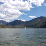
5 Awesome Summer Activities in Grand Lake, Colorado
Facebook Twitter WhatsApp SMS Email Print Copy article link Save Facebook Twitter WhatsApp SMS Email Print Copy article link Save The town of Grand Lake, Colorado is a premier adventure destination. It’s home to the largest natural lake in Colorado and has much to offer in the way of outdoor recreation and summer fun. 1. […]
5 Fall Activities in Grand Lake, Colorado
Facebook Twitter WhatsApp SMS Email Print Copy article link Save Facebook Twitter WhatsApp SMS Email Print Copy article link Save Fall is a beautiful time in the Rockies. The leaves are turning, the wildlife is stirring and summer is coming to a close. Nowhere else is there quite the excitement for fall than Grand Lake, […]