


The Winter Hike to Dream Lake in Rocky Mountain National Park
If you have been to Rocky Mountain National Park, you probably hiked this mega-popular trail from the Bear Lake trailhead to a stunning alpine lake. You probably had lots of company and may have had to take the shuttle bus from a far-off parking lot just to get close to the trailhead.
Visit in the “off season” and you’ll get a very different experience. This classic winter hike will drop your jaw when you experience the quiet beauty of this landscape in winter. Snowshoes aren’t always needed, though trails can get icy. The good traction provided by micro spikes will likely be helpful to bring along.
To Get There
This is doable as a day hike, but if you’ve got a long drive to the trailhead both ways, you’ll be exhausted. You’re better off staying in Estes Park, where in winter you can get a room for cheaper than the summer rate.
Normally, the park is reachable from U.S. Highway 36 from Loveland or U.S. Highway 34 from Lyons. You can also take Interstate 70 west to exit 243, the Central City Parkway, then follow Colorado Highway 119 north to Colorado Highway 72 in Nederland. Take 72 north and turn left on Colorado Highway 7 into Estes Park. This is known as the Peak to Peak Scenic Highway.
Another way to reach the Peak to Peak Scenic Highway is Boulder Canyon Road (Colorado Highway 119) west from Boulder to Nederland.
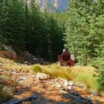
The Hike
While the main trail to Nymph Lake is marked and obvious, you can take a more pleasant snowshoeing path by walking around the west side of Bear Lake and, about a quarter of the way around, taking an unmarked path uphill. This will hold deep snow and is a straight shot through the quiet woods to Nymph Lake.
From Nymph Lake, follow the trail, which may or may not be evident, depending on traffic and recent snow, to the right of the lake. Continue up to Dream Lake.
Return the way you came or continue to the right of the lake for a side trip to Emerald Lake or follow the trail left for a more ambitious 5-mile loop back to the Bear Lake trailhead.
Details
– 2.2 miles round trip
– 425-foot elevation gain
*Editor’s Note: This article was originally published on October 23, 2013.
Get OutThere
Signup today for free and be the first to get notified on new updates.
PREV
PREVIOUS

6 Spots to Find Fall Colors in Colorado
Facebook Twitter WhatsApp SMS Email Print Copy article link Save Facebook Twitter WhatsApp SMS Email Print Copy article link Save Looking for a few great places close to the Front Range to find Colorado’s fall colors? Here are six spots that won’t disappoint. 1. Dome Rock State Wildlife Area This loop a few miles south […]
Hike to Ghost Town Hollow Hidden on Pikes Peak
Facebook Twitter WhatsApp SMS Email Print Copy article link Save Facebook Twitter WhatsApp SMS Email Print Copy article link Save Conquer your fear of ghosts on this trail that leads to an abandoned mine and ghost town high on Pikes Peak, lasting testaments to a failed effort to scratch some valuable minerals from the peak. […]