


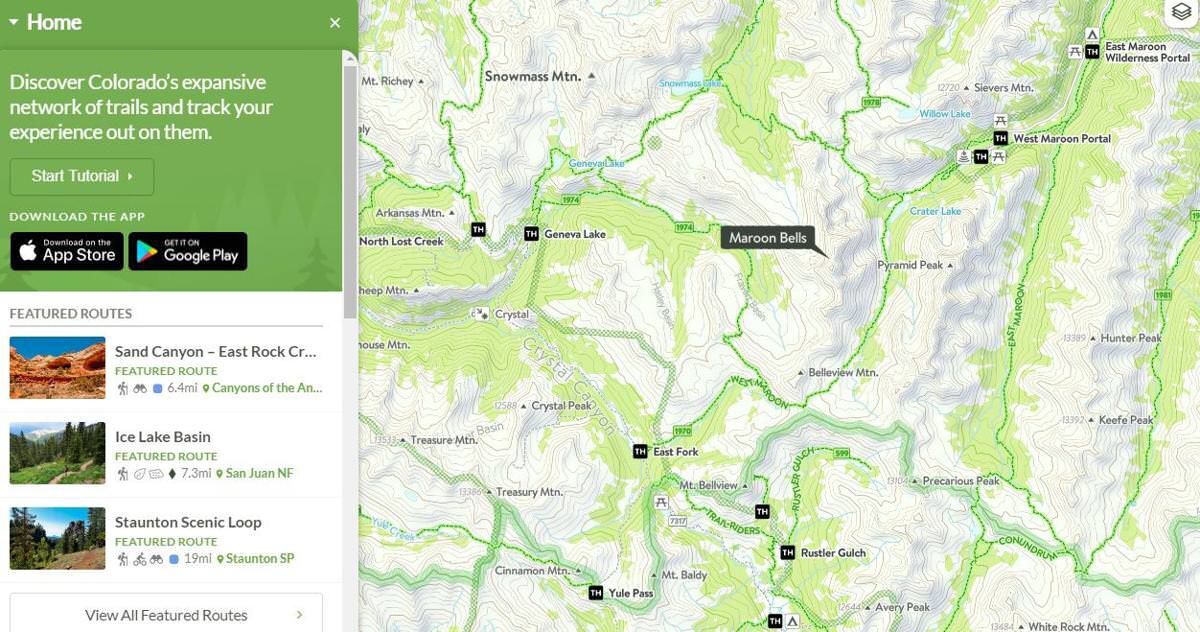
COTREX app details 39,829 miles of trails around Colorado
Other apps are out there.
AllTrails. Strava. Hiking Project. Go-to mountain-biking sources Singletracks and MTB Project.
But Colorado government is claiming one app to rule them all.
Allow the state Department of Natural Resources to introduce you to COTREX, short for Colorado Trail Explorer. Upon a free download, here are the numbers promised in the palm of your hand: 39,829 miles of trails, 2,350 trailheads and up-to-date information from 236 land managers across federal, state, city and county levels.
That last part is what makes COTREX different, says Alex Dean, who has overseen the half-a-million-dollar project three years in the making.
Other apps “have some data but not all,” Dean said. “And sometimes it’s not from a trusted source.”
COTREX heads into its first summer with a robust base of maps and profiles covering length, elevation, difficulty, terrain type and rules streamlined from the land manager responsible. The expectation is for users to build more data over time — trip reports and tips common to other apps.
Dean was on hand to announce COTREX at last month’s Partners in the Outdoors Conference, the annual event in Breckenridge bringing together land managers from around the West. He recalled some from New Mexico and Arizona approaching him, wondering how their states could develop such a resource.
“This is really setting a precedent,” Dean said. “We are the first state in the nation to do a project of this scale.”
The app is a byproduct of then-Gov. John Hickenlooper’s Colorado the Beautiful Initiative in 2016, meant to put the next generation of Coloradans within 10 minutes of trails, parks and open spaces.
“It’s one thing to build trails,” Dean said, “but there’s also the need for awareness for people who may not know there’s a trail available just up the road. I think this is that awareness tool.”
He also envisions it becoming “a dispersal tool.”
Say someone arrives at the packed parking lot of a trailhead. One could pull up the app, Dean said, “and it would be ideal in my mind that they’d be able to find something else 5 miles down the road equally as great.”

Denver council delays stadium rezoning, rejects Key Lime Air contract
Deborah Grigsby
deborah.smith@denvergazette.com
Updated 12 minutes ago
Denver’s dreams of a new women’s soccer stadium will have to wait a little longer as members of the city council voted Monday to delay an ordinance rezoning the land where the stadium is proposed to be built. Council Bill...
Deborah Grigsby
Reporter

‘Legally Blonde’ staged by Air Force Academy cadets? Elle, yes!
John Moore
john.moore@denvergazette.com
Updated 44 minutes ago
2025 DENVER GAZETTE TRUE WEST AWARDS: DAY 16 The cast was made up of ‘Bluebards’ – more than 40 Academy cadets, each destined to be an Air Force officer one day Michelle Ruehl, like Elle Woods, just finished No. 1 in...
John Moore
Reporter

Jeffco Public Schools workers to find about layoffs this week
Sage Kelley
sage-kelley@denvergazette.com
Updated 2 hours ago
Jeffco Public Schools employees received a voicemail from Superintendent Tracy Dorland Monday morning warning them of potential job cuts in the next year. “My holiday message this year is a more somber and serious one,” Dorland said in a voicemail...
Sage Kelley
Reporter

Denver man sentenced to life in prison for South Platte River Trail homicides
Sage Kelley
sage-kelley@denvergazette.com
Updated 4 hours ago
A Denver man will spend his life in prison after killing two people on the South Platte River Trail. A Denver District judge sentenced Tanner Fielder to life in prison without the possibility of parole Monday in connection to the...
Sage Kelley
Reporter

Aurora teen arrested in connection to Montview Park shooting
Sage Kelley
sage-kelley@denvergazette.com
Updated 4 hours ago
The Aurora Police Department arrested a 17-year-old boy in connection to a fatal shooting in November. The department arrested the male — who will not be identified due to being a minor — on Monday on suspicion of first-degree murder...
Sage Kelley
Reporter

US claims 90% of obstacles to Russia-Ukraine agreement solved in Germany talks
Mike Brest Washington Examiner
mike-brest-washington-examiner@denvergazette.com
Updated 5 hours ago
Ukrainian President Volodymyr Zelensky met in Berlin on Monday with senior American and European leaders for the second consecutive day, in the United States’s latest attempt to end the Russia-Ukraine war. Zelensky spent roughly eight hours on Sunday and Monday...
Mike Brest Washington Examiner
Reporter

2025 Holiday Events in and around Denver
Carlotta Olson
carlotta-olson@denvergazette.com
Updated 5 hours ago
MUSIC Through Dec. 20: Strolling Holiday Carolers — Weekends, The Shops at Northfield, 8340 Northfield Blvd., Denver; shopsatnorthfield.com/events. Dec. 15: My Favorite Queens — Presented by the Denver Gay Men’s Chorus, 3 p.m., St. Andrew United Methodist Church, 9203 S. University...
Carlotta Olson
Reporter

Supreme Court to hear death row inmate’s challenge of racial bias in jury selection
Jack Birle, Washington Examiner
jack.birle.washington.examiner@gazetteedit.wpenginepowered.com
Updated 5 hours ago
The Supreme Court announced on Monday it will take up a death row inmate’s challenge over allegations that the dismissal of four black jurors during his trial was unlawful, adding to the justices’ caseload for the current term. The high...
Jack Birle, Washington Examiner
Reporter
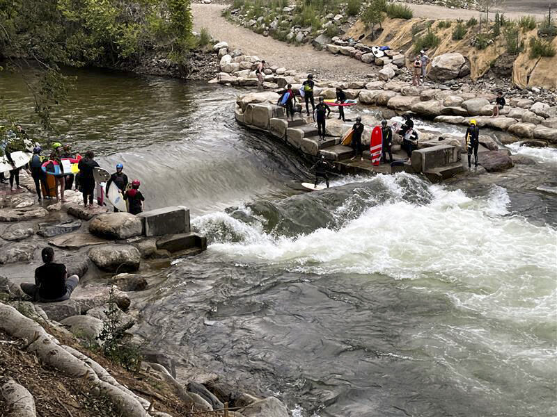
Colorado whitewater parks inhibiting fish migration, CPW study finds
Jonathan Ingraham
jonathan.ingraham@denvergazette.com
Updated 6 hours ago
Flannelmouth suckers only had a 2% passage probability, making for an almost impassable barrier A study published in October by Colorado Parks and Wildlife (CPW) researchers suggests features built at man-made whitewater parks (WWPs) are having negative impacts on fish passage....
Jonathan Ingraham
Reporter

Xcel Energy prepares for power shutoffs to help prevent a repeat of the Marshall fire
Scott Weiser
scott-weiser@denvergazette.com
Updated 2 hours ago
Forecast high winds along the Front Range on Wednesday revive memories of the devastating 2021 Marshall fire that destroyed more than 1,000 homes when gusts downed energized power lines. Xcel Energy now weighs proactive power cuts to avoid similar ignitions...
Scott Weiser
Reporter
PREV
PREVIOUS
Coroner IDs man who died in rafting accident in Colorado
Facebook Twitter WhatsApp SMS Email Print Copy article link Save Facebook Twitter WhatsApp SMS Email Print Copy article link Save AVON, Colo. (AP) — Authorities have released the name of a man who died in a rafting accident on Colorado’s Eagle River. Eagle County Coroner Kara Bettis identified the victim late Thursday night as 29-year-old […]

Longs Peak toilets win award for architectural design
Facebook Twitter WhatsApp SMS Email Print Copy article link Save Facebook Twitter WhatsApp SMS Email Print Copy article link Save If you’ve made the trek to the summit of Longs Peak via the Keyhole Route, you probably remember passing outhouse structures along the way. If you’ve made the trek very recently, know that the outhouse […]