


Hail, torrential rain, and strong winds headed to Colorado

milehightraveler
The National Weather Service issued a hazardous weather outlook for several parts of Colorado on Tuesday, calling for large hail, 50 mph winds, and torrential downpours.
Thunderstorms rolling in late Tuesday afternoon and early evening, September 10, across northeast, north central, south central, and southeast Colorado will produce heavy rain, lightning, and strong gusty winds. A few storms could approach severe limits, with the main threats consisting of nickel-sized hail or larger and 50 mph winds along the Front Range urban corridor and portions of Baca, Prowers, eastern Las Animas, and eastern Kiowa counties from this afternoon into this evening, September 10. Storms will diminish by late evening.
Warmer with widely scattered afternoon storms. #cowx pic.twitter.com/bUFrUx351k — NWS Boulder (@NWSBoulder) September 10, 2019
Snow is also on the horizon for the Centennial State. Cooler temperatures and precipitation could bring a dusting of snow to higher elevations possibly this week and next.
Stay away from windows and remain indoors during wild weather in Colorado. If you get caught in a hail storm while driving, pull over to a safe place. Hail is blinding and may shatter side and back windshields. Stay safe out there and be prepared for wild weather in Colorado.
See the full report here.
Please note that all weather statements are subject to change or extend.

Denver area events for March 3
Carlotta Olson
carlotta.olson@gazette.com
Updated 14 hours ago
If you have an event taking place in the Denver area, email information to carlotta.olson@gazette.com at least two weeks in advance. All events are listed in the calendar on space availability. Tuesday Denver Cocktails Tour — 4:30-6:30 p.m., Denver, $83.74-$90.10. Registration required:...
Carlotta Olson
Reporter

Colorado lawmakers tackle legislation on sexual assault
Jenny Deam
jenny.deam@gazette.com
Updated 7 hours ago
A panel of Colorado lawmakers on Monday unanimously approved a bill that supporters say will offer protections and support to victims of domestic violence, stalking, sex trafficking and sexual assault, including mandatory training for law enforcement on trauma. The measure,...
Jenny Deam
Reporter

Denver adopts face mask ban for law enforcement
Deborah Grigsby
deborah.smith@denvergazette.com
Updated 9 hours ago
Members of the Denver City Council unanimously approved an ordinance Monday that prohibits law enforcement officers, including federal immigration agents, from wearing a mask or face covering while interrogating, detaining, or arresting an individual within Denver, including in city-owned buildings....
Deborah Grigsby
Reporter

More than 20 Colorado counties receive grants to improve land record-keeping systems
Maren Prince
maren.prince@denvergazette.com
Updated 10 hours ago
More than 20 Colorado counties received $2.5 million to improve their land record-keeping systems, according to a Monday news release. The State’s Electronic Recording Technology Board awarded 22 counties with grants ranging from $5,000 to $350,000, according to the release....
Maren Prince
Reporter

Denver among top 5 finalist cities for 2028 DNC
Deborah Grigsby
deborah.smith@denvergazette.com
Updated 11 hours ago
Denver is among the five cities that could host the 2028 Democratic National Convention, the Democratic National Committee announced Monday. Along with Denver, Philadelphia, Atlanta, Boston and Chicago have advanced in the application process to host the next DNC, which...
Deborah Grigsby
Reporter
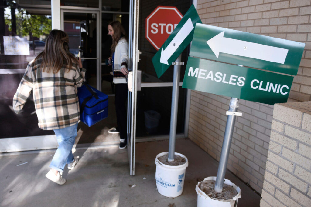
Broomfield High School keeps 26 students out after confirmed measles case
Nicole C. Brambila nico.brambila@denvergazette.com
nico.brambila@denvergazette.com
Updated 10 hours ago
After state officials confirmed a measles case last week at Broomfield High School, 26 students are not allowed to attend class, the district said Monday. On Friday, school officials requested students who are not vaccinated against measles to not attend...

Appeals court sends tariff refund lawsuits to trade court after Trump loss
David Zimmermann, Washington Examiner
david.zimmermann.washington.examiner@gazetteedit.wpenginepowered.com
Updated 12 hours ago
A slew of lawsuits seeking refunds from tariffs are returning to the U.S. Court of International Trade due to a federal appeals court’s Monday ruling. The decision, issued by the U.S. Court of Appeals for the Federal Circuit, comes after...

Biden judge blocks Noem from banning lawmaker visits at ICE detention sites
Anna Giaritelli, Washington Examiner
anna.giaritelli.washington.examiner@gazetteedit.wpenginepowered.com
Updated 12 hours ago
A federal judge appointed by former President Joe Biden upheld a restraining order against the Department of Homeland Security after the Trump administration attempted to ban members of Congress from visiting Immigration and Customs Enforcement detention sites with less than...
Anna Giaritelli, Washington Examiner
Reporter

Democrats face choice to reopen DHS amid fears of Iran terrorist proxies retaliating inside US
Rachel Schilke, Washington Examiner
rachel.schilke.washington.examiner@gazetteedit.wpenginepowered.com
Updated 12 hours ago
House Democrats will be forced to decide this week whether to reopen the Department of Homeland Security or keep the agency charged with protecting the country from terrorism closed as threats of Iranian terrorist cells retaliating inside the United States...
Rachel Schilke, Washington Examiner
Reporter

Metro Moves: Visit Estes Park names new executive
Bernadette Berdychowski
bernadette.berdychowski@denvergazette.com
Updated 13 hours ago
Welcome to the Denver Gazette’s Metro Moves. You’ll get the latest metro Denver openings, closings, hiring and promotion news here. To submit your company’s news, drop an email to bernadette.berdychowski@denvergazette.com. The tourism agency representing the gateway city into Rocky Mountain National...
Bernadette Berdychowski
Reporter
PREV
PREVIOUS

Rare moon to appear above Colorado on Friday the 13th
Facebook Twitter WhatsApp SMS Email Print Copy article link Save Facebook Twitter WhatsApp SMS Email Print Copy article link Save It’s full moon madness on Friday. Not only will it occur on Friday the 13th, but it will also be this year’s Harvest Moon as well as a Micro Moon. The Harvest Moon is the […]

Enter for a chance to win a VIP hard seltzer experience in Denver
Facebook Twitter WhatsApp SMS Email Print Copy article link Save Facebook Twitter WhatsApp SMS Email Print Copy article link Save There will be no more hard seltzer shortages for one lucky winner headed to the first-ever hard seltzer festival to hit the Mile High City. To all hard seltzer lovers, here’s your chance to win […]