







12 inches of snow to hit Colorado cities earlier than expected this weekend
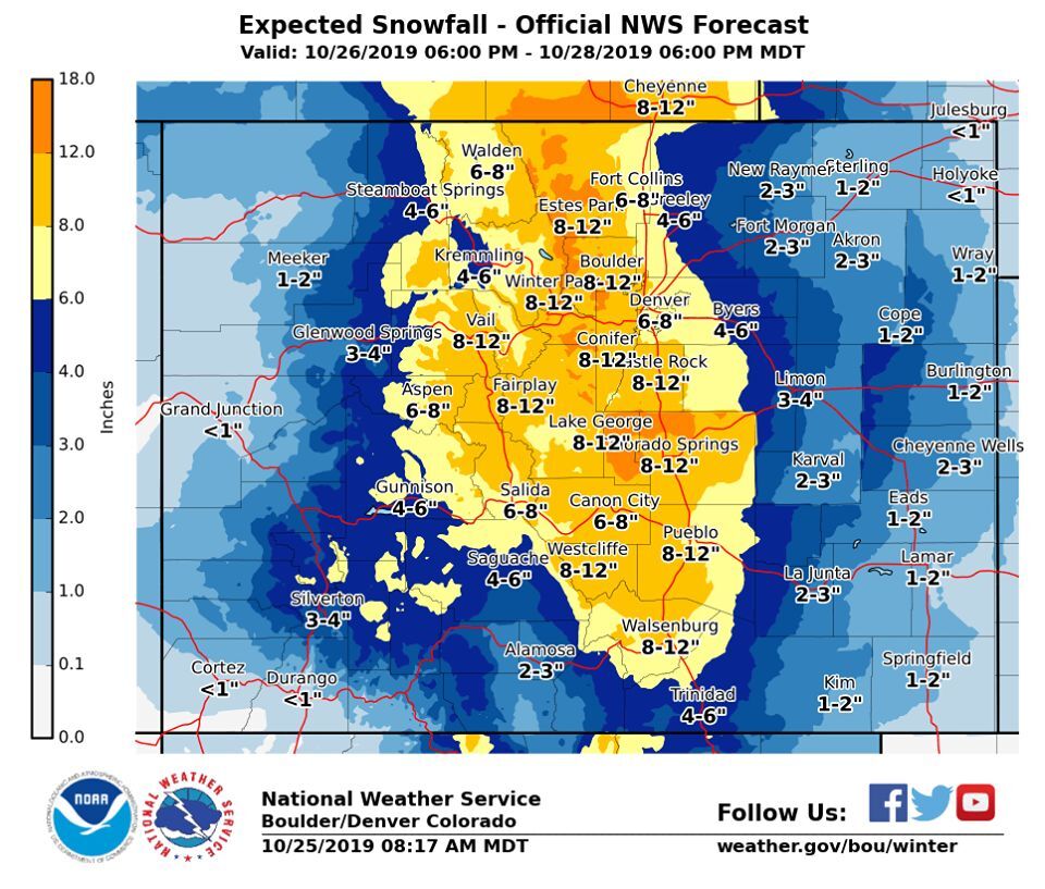
Don’t be fooled by sunny skies and warm temperatures. A storm that was previously expected to arrive on Sunday, continuing through Wednesday, is now expected to start hitting hard in Colorado on Saturday night.
Warm & dry weather on Saturday. Big changes are on the way Saturday night – Tuesday as a storm system & strong cold front moves across the state. Snow is expected Sunday & Sunday night which will make for a slippery commute Monday morning. #cowx pic.twitter.com/VeTZUMvtc6 — NWS Boulder (@NWSBoulder) October 25, 2019
According to the National Weather Service, up to 12 inches of snow will be landing in many Colorado towns between Saturday and Monday, including Colorado Springs, Castle Rock, Pueblo, Estes Park, Boulder, Vail, Fairplay, Walsenburg, Westcliffe, and Winter Park. Up to 8 inches of snow is expected in the Denver area, Cañon City, Aspen, Fort Collins, and Salida. Most of the state should receive some amount of snow during this period.
According to OpenSnow, Arapahoe Basin, Keystone, and Loveland Ski Area are all expected to get around 9 inches of fresh powder over the next 5 days.
A tweet from the National Weather Service mentions that a recurving typhoon in the West Pacific is responsible for the snow and cold weather.
For the #weathernerds out there, look at how the recurving typhoon leads to the deepening of an anomalously strong trough that is responsible for our snow and bitter cold early next week. The weather is connected on a global scale! #COwx https://t.co/bv6zv5L5Xj — NWS Boulder (@NWSBoulder) October 25, 2019
The National Weather Service warns that this incoming snow will be particularly problematic for travel around the state throughout Sunday and on Monday morning. Be aware of the new traction laws if you’re on the road.
A second wave of snow is expected to move into the state on Tuesday through Wednesday, dumping up to 5 additional inches of powder.
This storm comes days after up to 20 inches fell in Colorado.