







Flood threat continues in Colorado, with Monday storms expected in some parts of the state
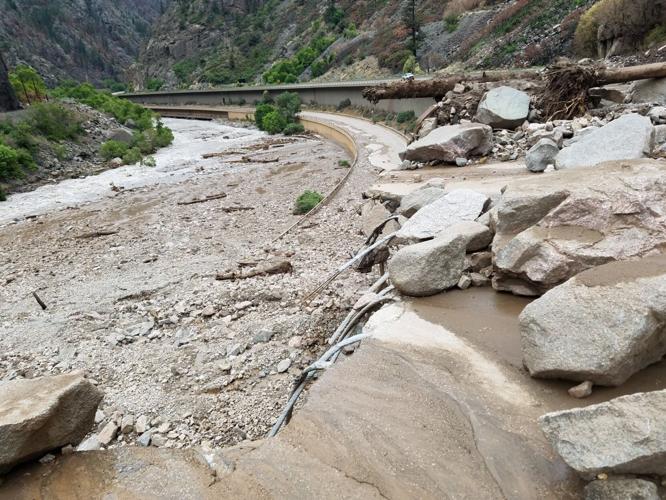
Interstate 70 through Glenwood Canyon will continue to be closed due to “extreme damage” from mudslides. Photo Courtesy of The Colorado Department of Transportation (CDOT).
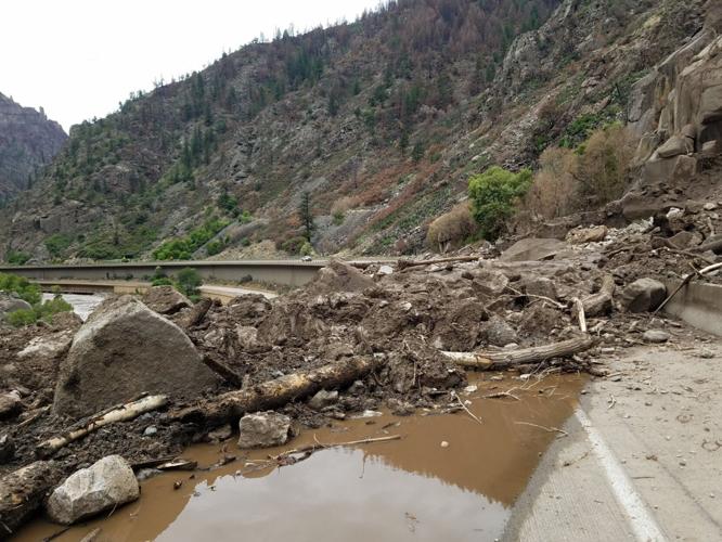
A dangerous flood threat continues in Colorado with heavy monsoon rain set to keep hitting parts of the state on Monday. This follows massive mudslides that swept over Interstate 70 in Glenwood Canyon this weekend, closing the road, trapping travelers, and causing “extreme damage” in what officials say is “unlike anything they had seen before.”
Monday is expected to be stormy in some areas, resulting in warnings of flash flooding and more mudslides.
Early morning showers will give way to stronger convection early this afternoon starting near the high terrain. Frequent lightning, heavy rainfall, and gusty winds remain the main threats. pic.twitter.com/DXOFmXsM1Z
— NWS Grand Junction (@NWSGJT) August 2, 2021
A flash flood watch is in effect for portions of central and western Colorado and several other mountainous areas of the state through at least Monday evening, according to the National Weather Service (NWS).
With the monsoon plume shifting eastward, burn scars will be at a greater risk for flash flooding today. Please stay weather aware today and have multiple ways to receive warnings, especially if you are in or near burn scars. #cowx pic.twitter.com/khqtbqn0uM
— NWS Pueblo (@NWSPueblo) August 2, 2021
NEWSLETTER: Sign-up for the free OutThere Colorado newsletter here
“The Monsoon plume will push eastward and bring another day of slow moving, heavy rain producing thunderstorms to the area,” the watch warns. “Flash flooding will be possible, especially considering the already saturated soil conditions. Burn scars will be especially susceptible.”
Places impacted include Aspen, Vail, Snowmass, Crested Butte, Taylor Park, Marble, Buford, Trappers Lake, Ridgway, Glade Park, Telluride, Ouray, Lake City, Silverton, Eagle, Edwards, Glenwood Springs, Carbondale, Basalt, Gunnison, Kenosha Mountains, Hot Sulphur Springs, Kremmling, Indian Peaks, Dillon, Eisenhower Tunnel, Fraser, Mount Evans, Laramie and Medicine Bow Mountains, Grand Lake, Cameron Pass, Granby, Breckenridge, Winter Park, Rocky Mountain National Park, Willow Creek Pass, Rabbit Ears Range, and Berthoud Pass.
Early morning showers will give way to stronger convection early this afternoon starting near the high terrain. Frequent lightning, heavy rainfall, and gusty winds remain the main threats. pic.twitter.com/DXOFmXsM1Z
— NWS Grand Junction (@NWSGJT) August 2, 2021
Mud flows and rock slides will be possible around burn scars and steep terrain. Creeks, streams, and normally dry washes may experience rapid flooding with damage to roads possible.
Flash flooding will remain a high possibility on Tuesday over the mountains, valleys, and the plains, including the I-25 corridor, according to the NWS.
Editor’s Note: Never drive through flooded roadways. Avoid flooding-prone areas including canyons, rivers, and burn scars, before, during, and after rainfall. Get the latest on the forecast with the National Weather Service. Check cotrip.org for closures and delays on highways and roads across the state
DISCOUNT: Help support OutThere Colorado through our online store. Explore t-shirts, hoodies, gaiters, mugs, stickers & more. Use code OTCGEAR15 at checkout for 15% OFF.