


This route bags three Colorado fourteeners in one fell swoop

The ridge on the north side of Missouri Mountain. Photo by Nathan Van Dyne, The Gazette
Nathan Van Dyne, The Gazette


Life is different above tree line.
The wind blows harder. The sun shines brighter. And everything moves slower.
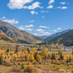
There is, after all, a reason why trees stop growing at about 12,000 feet. Keep that in mind if you find yourself hiking through Missouri Gulch in the Sawatch Range of central Colorado.
The trail is a popular launching spot for a trio of 14,000-foot peaks — Mt. Belford, Mt. Oxford and Missouri Mountain. Most hikers choose to summit either Belford or Missouri. Some opt for the straightforward, out-and-back Belford-Oxford combo.
On this day, our plan was to bag all three.
We began hiking under the stars, our headlamps lighting the rocky path that rises through the forest. The cold air and steep switchbacks combined to provide an effective, albeit annoying, wake-up call. And hitting snooze wasn’t an option.
After crossing a river just more than a mile into the hike (note: speaking from past experience, missing this bridge and continuing on through the willows is a time-consuming, shoe-soaking mistake), we soon emerged above tree line and reached a trail junction.
Turn left and face the climb to the 14,197-foot summit of Belford. Or continue straight toward Missouri.
We opted for Belford first, mostly because I’d rather ascend its steep, somewhat slick shoulder on fresh legs than descend it (note: speaking from past experience, trips down fourteeners sometimes don’t go as planned) hours later on tired legs.
From Belford, it’s a relatively easy scamper to the 14,153-foot summit of Oxford. The return trip to Belford, however, is not so easy and better described as a slog. But, for us, it served as the midway point of the mission.
Shortly before reaching the top of Belford for the second time, we veered to the south on a smooth trail and looped back down to the base of Missouri Mountain.
After climbing, then descending, then climbing, then descending, then climbing and then descending again, it was with great reluctance that we pushed toward one last steep wall of switchbacks.
I’d been up Missouri a few times, but it was a brand-new experience on the heels of two other mountains. Still, we pressed on until we stood atop the 14,067-foot summit — capping a beautiful morning above tree line I won’t soon forget.
Trip log: 16.4 miles, 7,100 feet elevation gain, 14,197 feet max
Difficulty: Very difficult
Getting there: Drive west on U.S. 24 to Buena Vista. From the center of town, head north for 14.5 miles to County Road 390. Turn left and follow 7.5 miles to trailhead.
FYI: Dispersed camping available along County Road 390. Restroom at trailhead. Keep dogs leashed.
Get OutThere
Signup today for free and be the first to get notified on new updates.
PREV
PREVIOUS
Happy Trails: Rugged Arkansas Point a go-to for hikers at Lake Pueblo
Facebook Twitter WhatsApp SMS Email Print Copy article link Save Facebook Twitter WhatsApp SMS Email Print Copy article link Save Arkansas Point Lake Pueblo is first known for boating. It is next known for fishing and mountain biking, with a web of trails on the south shore exploring rugged bluffs. On this side of the […]
‘Heart of the High Country’ is Colorado’s ultimate mountain adventure getaway
Facebook Twitter WhatsApp SMS Email Print Copy article link Save Facebook Twitter WhatsApp SMS Email Print Copy article link Save At 9,318 feet, Silverton lives up to its nickname – the ‘heart of the high country.’ The area is the only incorporated town of San Juan County and houses about 600 year-round residents. Silverton was […]