


Up to 8 inches possible in Colorado as forecast intensifies, travel impacts expected
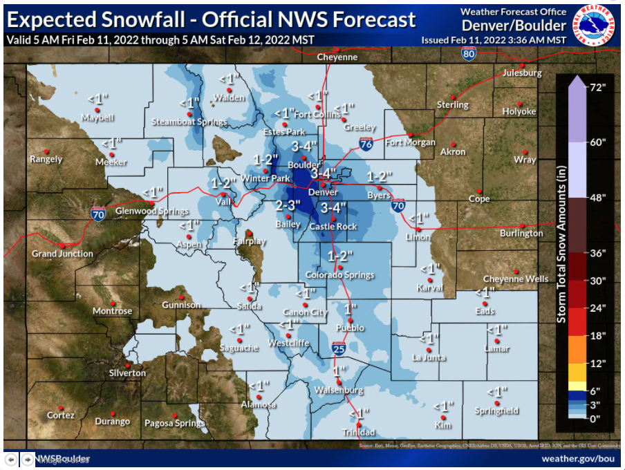
An elevated risk of travel impacts is present along parts of the Colorado Front Range, with a snowstorm set to hit the state on Friday night as a cold front combines with a shallow upslope flow.
According to the National Weather Service, not much snow will be falling, but it will be falling in the Denver area during the heavy traffic of the Friday night commute. Wet roads are expected to transition to slick and snowy roads as night falls, with colder temperatures and banded snowfall moving into the area.
This wave of snow is expected to be more intense than originally thought, now expected to hit the southwest Denver metro area the hardest, with four to six inches possible in Evergreen through Saturday morning. Boulder, Denver, and Castle Rock are expected to get three to four inches, with limited totals elsewhere.
It’s also worth noting that there is a 10 percent chance that higher snowfall will take place. Should that occur, areas likely to see the most snow may see up to eight inches, with the downtown Denver metro area seeing five.

The National Weather Service has cautioned drivers that the biggest impacts will be seen in the Denver metro area (especially the southwest side) and along I-70, east of the tunnel. Multiple highways will be impacted, including I-25, I-70, and US-285.

The rest of the weekend is expected to be relatively clear statewide.
While this round of snow will contribute to Colorado’s dwindling snowpack in some parts of the state, totals aren’t expected to be very deep and those deeper totals are unlikely to be widespread.
Those traveling around Colorado should plan ahead. Make sure the trunk is packed with the winter essentials prior to travel.
STAY INFORMED: Sign-up for the daily OutThere Colorado newsletter here

Get OutThere
Signup today for free and be the first to get notified on new updates.
PREV
PREVIOUS
Colorado Politicking | February 11, 2022
This week on Colorado Politicking, chief legislative reporter Marianne Goodland and host Pat Poblete highlight Sen. Steve Fenberg, a Boulder Democrat who was this week picked by his Democratic colleagues to take over as Senate president.
Bill permits inspection of funeral homes, crematories after ‘atrocities’
In the last few years, Colorado has become the epicenter for malpractice in the funeral industry. Now, lawmakers are trying to fix that with legislation to allow inspections of funeral homes and crematories without first getting an operator’s permission to enter premises. In 2020, the owners of Sunset Mesa Funeral Home in Montrose were arrested for […]