


Happy Trails: Fun by water and land at state park west of Colorado Springs

View from Coyote Ridge Trail at Eleven Mile State Park.
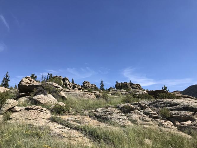

Coyote Ridge loop
In Park County, Eleven Mile State Park is best known for its recreation on water. Kayakers, sailors, stand-up paddelboarders and anglers mingle on the 3,400 surface-acre reservoir. But the offerings on land are enticing, too.
Many opt for some 325 campsites, accommodating tents and hook-up trailers. But we’ve always found few take advantage of the trails.
Sure, it’s a modest system — a series of loops covering about 5 miles. But the variety of nature packed into that is surprising.


Coyote Ridge Trail at Eleven Mile State Park. Gazette photo
First, the views: the rock-festooned Tarryall Range all encompassing and a regal Pikes Peak and rolling Continental Divide. The reservoir shimmers in frequent sight, too. And along the trails you’ll be met by pines, aspens, meadows and rock gardens.
A fine introduction is the Coyote Ridge Trail, which accounts for the Ponderosa and Aspen loops as they’re mapped and marked.
We started from the southeast corner of the Coyote Ridge parking lot, electing to do the loop counter-clockwise. Ponderosa Trail skirts a scenic cove before springing to the left at a marker pointing straight to the campground. Go left, beside the tree-bordered wetlands.


The Ponderosa and Aspen Loop trails, which take off from the Coyote Ridge parking lot within Eleven Mile State Park, feature a variety of ecosystems on the short hike.
At the next post, go right. And at the next post where you could go right for Midland Trail — the longer of the loops — stay straight for the Aspen Trail. Ahead, you’ll marvel at a mountain-shaped outcrop.
The trail trends north and gently rises to an overlook with a bench. At a marker beside a small cave, stay straight, continuing down through granite passages. Ahead, slightly off trail before the return to the parking lot, a table-like rock offers the best vista.
Trip log: 1.38 miles round trip, 210 feet elevation
Difficulty: Easy
Getting there: Getting there: From Colorado Springs, go west on U.S. 24 through Woodland Park and Florissant. In Lake George, turn left for County Road 90. About 10 miles to the park.
FYI: $9 day fee per vehicle. Hiking only. Day use 6 a.m.-10 p.m.

Understanding the rise of VPN friendly casinos in online gambling
Sponsored Content
sponsored-content@denvergazette.com
Updated 2 months ago
The landscape of online gambling has evolved dramatically in recent years, with the emergence of VPN friendly casinos playing a pivotal role in this transformation. As restrictions tighten around the globe, more players are turning to Virtual Private Networks (VPNs)...
Sponsored Content
Reporter

Exploring the dynamic landscape of new casinos in the UK
Sponsored Content
sponsored-content@denvergazette.com
Updated 2 months ago
The realm of online gambling in the UK continues to evolve, with new casinos uk making their mark on the industry. These fresh platforms are gaining traction by offering unique experiences, enhanced features, and enticing bonuses to attract players from...
Sponsored Content
Reporter

How an 815 Credit Score Secures Better Loan Options
Sponsored Content
sponsored-content@denvergazette.com
Updated 3 months ago
Most borrowers notice a quiet shift once their credit moves into the upper tiers. The offers feel different, the terms seem lighter, and the entire borrowing process carries less tension. An 815 credit score sits squarely in that space where...
Sponsored Content
Reporter

Exploring Denver From Home: Digital Experiences to Try Locally
Sponsored Content
sponsored-content@denvergazette.com
Updated 4 months ago
Denver buzzes with life, from its iconic skyline all the way to the glorious mountains surrounding the city. Here’s a secret that not everyone knows: some of the best experiences occur without ever having to navigate traffic, crowds, and parking...
Sponsored Content
Reporter
Denver’s Quarterback Situation: Early Expectations And Real Tests
Sponsored Content
sponsored-content@denvergazette.com
Updated 4 months ago
Facebook Twitter WhatsApp SMS Email Print Copy article link Save Denver opens the season with public title ambitions and a second-year starter at the controls. Bo Nix arrives from a record-setting rookie year, yet the test now shifts from surprise...
Sponsored Content
Reporter
Managing Financial Stress: Can Short-Term Loans Help?
Sponsored Content
sponsored-content@denvergazette.com
Updated 4 months ago
Facebook Twitter WhatsApp SMS Email Print Copy article link Save More Americans are struggling to stay financially afloat. With inflation raising the cost of basics like rent, groceries, and car repairs, many households are left with little margin for emergencies....
Sponsored Content
Reporter
Underdogs to Watch: Sleeper Picks for the 2025 Belmont Stakes
Sponsored Content
sponsored-content@denvergazette.com
Updated 4 months ago
Facebook Twitter WhatsApp SMS Email Print Copy article link Save Picture Credit The 2025 Belmont Stakes brings a shift in tradition and a reshuffling of expectations. Moved to Saratoga Race Course due to ongoing renovations at Belmont Park, this year’s...
Sponsored Content
Reporter
Key Matchups to Watch: Broncos vs. Chargers 2025 Season Preview
Sponsored Content
sponsored-content@denvergazette.com
Updated 4 months ago
Facebook Twitter WhatsApp SMS Email Print Copy article link Save Picture Credit The 2025 NFL season brings renewed intensity to the AFC West, particularly between two ambitious rivals—Denver and Los Angeles. The Broncos and Chargers are poised for two critical...
Sponsored Content
Reporter
The Evolution of Women’s Sports: Redefining Engagement for the Next Generation
Sponsored Content
sponsored-content@denvergazette.com
Updated 4 months ago
Picture Credit Photo by Jeffrey F Lin on Unsplash Women’s sports have evolved from being a marginal athletic attraction to becoming a vibrant and integral part of the global sports landscape. This evolution, shaped by perseverance, advocacy, and cultural shifts, has not only...
Sponsored Content
Reporter
Factors That Allowed Bitcoin to Exceed $100k
Sponsored Content
sponsored-content@denvergazette.com
Updated 4 months ago
source Bitcoin has finally hit the $100k mark, a huge psychological barrier people have been discussing since 2017. Every time it spiked, people started talking about the $100k mark, and every time it went down, crypto skeptics gloated that it...
Sponsored Content
Reporter
PREV
PREVIOUS

Mourners gather at Colorado Capitol for Fentanyl Prevention and Awareness Day
Portraits of fentanyl victims were balanced on black folding chairs that lined the lawn in front of Colorado’s Capitol on Sunday. The chairs were decorated with flowers and birthday balloons. Mourners studied the faces of their children and people they would never know. “Joshua met (basketball legend) Charles Barkley on his 10th birthday and Charles […]

Denver to create own paid-family leave plan after council opts out of new state program
Denver City Council voted overwhelmingly Monday to opt the city out of a statewide paid-family leave program, one passed by Colorado voters two years ago, in favor of a Denver-specific benefit that could be available sooner. The council voted 12-1 — with strong dissent from council member Candi CdeBaca — to launch Care Bank, which […]