


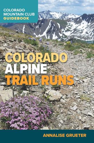
New book features 45 high alpine trail runs in Colorado — we asked for some favorites

A runner ascends Mount Bierstadt as dawn break. The 14,000-foot mountain is featured in Annalise Grueter’s new guidebook on high alpine trail running in Colorado.


As a teenager in Colorado’s Roaring Fork Valley, Annalise Grueter could not believe the order of her cross country team coach.
“We were going to be hiking/jogging a (13,000-foot mountain) for training that July day,” she recalled. “I was like, ‘What are we doing? This is a thing?’”
Flash forward to today, running up mountains is most definitely a thing. Grueter has seen the growth firsthand.
That July day was the start of a lifelong passion. On any given weekend, Grueter can be found dashing around the state’s high country with a legion of like-minded individuals drawn to a hard test and rare aesthetics.
“It’s such a pure way of connecting with the outdoors and the backcountry,” Grueter said. “The only thing between you and the trail is your shoes, and there are a lot of things you can see when you’re moving fast and light.”
The way she sees it, the appeal has been bolstered, too, by the expansion of smoother, less-obstructed trails across Colorado.
“Granted, there are sections in the Elk Range and the San Juans and the Sangre de Cristos that are very steep and more climbable than they are runnable,” Grueter said. “But there are huge swaths of backcountry that are very easy and pleasant to explore on foot.”
Those swaths are featured in her new Colorado Mountain Club guidebook, “Colorado Alpine Trail Runs.”
Grueter details 45 routes for the fleet-footed and well-prepared, all boasting scenery above tree line while ranging in length, vertical and “runability,” according to a score by Grueter.
We asked her for some of her favorites. Perhaps routes to consider for your last great run before snow packs the high elevations:
Bear Lake
Where: Sawatch Range, outside of Buena Vista
Details: 10.7 miles (out and back), 2,700 feet elevation gain, 95% runability (out of 100)
Grueter’s photos of the destination above 12,400 feet depict a lonely, solitary body of water, seemingly out of place in a wide spread of rock. Mount Harvard hangs above with more soaring peaks.
“It’s kind of hidden; you wouldn’t know that the lake is there if you were just studying a route description for the summit,” Grueter said. “It’s in this little divot that hides it from view of the average hiker.”
You’ll need a high-clearance, four-wheel drive to get to the North Cottonwood Creek trailhead. “The trail itself is really nice and gradual,” Grueter said.
Electric Pass
Where: Elk Range, outside of Aspen
Details: 12 miles (out and back), 4,100 feet elevation gain, 70% runability
Between Electric Pass Peak and Leahy Peak — the latter “is not on maintained trail, so step mindfully,” the author warns — Grueter notes “a glittering teal lake” within “a ring of 13,000-foot peaks” and “a riot of colorful geologic features.”
The high point above 13,600 feet offers vivid, contrasting scenes of several valleys. “An exhilarating, beautiful run,” she writes of the descent.
“A lot of it is really well-built trail that’s fairly easy on the feet, even when you hit, I believe, seven steep switchbacks,” she said.
Mount Flora
Where: Off Berthoud Pass, nearest Empire and Idaho Springs
Details: 6.2 miles (out and back), 2,275 feet elevation gain, 75% runability
“It’s one of the easier routes in the book,” Grueter said. “But it also gives you a taste of some slightly different types of terrain and has really gorgeous views. It’s especially a good sunrise or sunset run.”
From the broad summit of Flora, the views include the Gore Range and Rocky Mountain National Park. Grueter describes the trail as “good singletrack with rolling features that help wake up the legs.”
Handies Peak
Where: San Juan Range, outside of Lake City
Details: 8.2 miles (out and back), 3,650 feet elevation gain, 85% runability
This is one of several fourteeners Grueter features in the book, some others being mounts Bierstadt and Elbert and Pikes, Quandary and Humboldt peaks. Unlike some of the others, a high-clearance, four-wheel drive is recommended to reach the starting point.
The suggested route from the Grizzly Gulch trailhead features terrain covered in the legendary Hardrock 100 race. Recent trail work “has made this approach a runner’s dream,” Grueter writes, “with smooth log steps marking out much of the first mile as the trail ascends through old-growth coniferous forest.”
Phantom Terrace
Where: Sangre de Cristo Range, outside Westcliffe
Details: 12.6 miles round trip (loop), 4,400 feet elevation gain, 85% runability
Grueter charts a clockwise course from the Comanche trailhead to the Venable trailhead, covering a half-marathon distance and a full buffet a vistas. She offers a variation netting an extra 1,500 feet and a trio of 13,000-foot peaks — “should you be in the mood for some classic, ridgy skyrunning,” she writes.
“It technically doesn’t exceed Class 2 in hiking terms, but it’s a little bit spicier than just staying on an established trail,” she said. “And it’s super gorgeous.”