




Colorado snowpack strong across most of state, moving from ‘just OK to quite good’
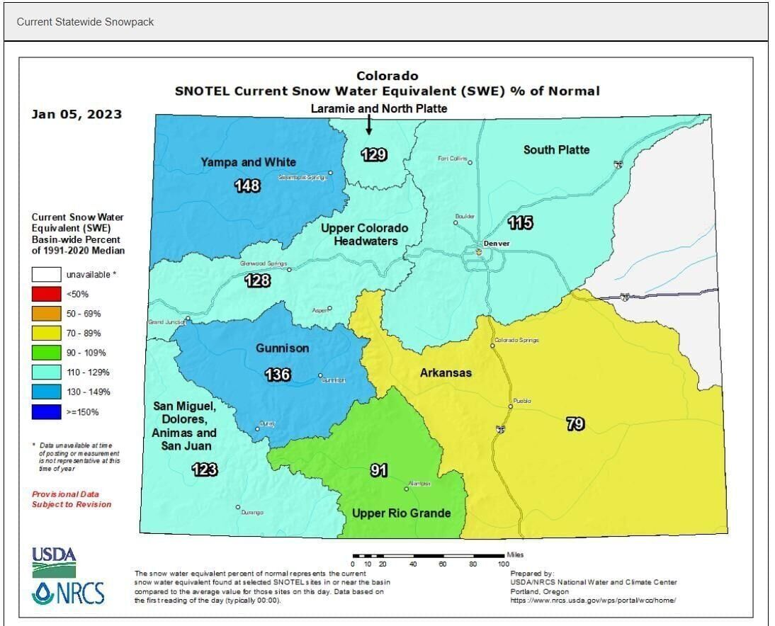
Powder across Colorado’s high country has pushed snowpack above average and eased drought conditions across the state, but it is still too soon to make predictions about the water year.
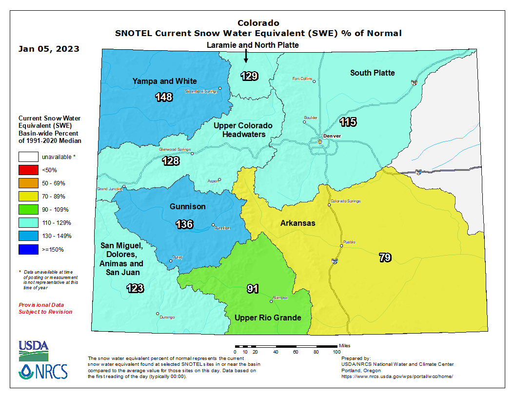
The Natural Resources Conservation Service estimates the state’s snowpack is 124% of the median, with only the Arkansas River basin’s levels of snow tracking well below normal levels, the data shows.
“We went from just OK, to quite good in a couple of weeks,” Colorado Climatologist Russ Schumacher said.
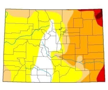
The snow also eased dry conditions significantly from late December to early January, according to the U.S. Drought Monitor with the percentage of drought-free areas in the state increasing from 13.75%, covering the central mountains and south into the San Luis Valley, to 40% of the state, an area encompassing much of the Western Slope.
Colorado Springs Utilities expert Kalsoum Abbasi said she is cautiously optimistic based on experience.
“Starting the season with some good snowfall, especially in places that have struggled to achieve even average snowpack the past few winters, gives us hope that the rest of season will follow suit,” said Abbasi, water conveyance planning supervisor for Utilities.
Right now, Utilities staff members are not seeing “spectacular snowpack totals” near the watershed collection system, which relies heavily on the Colorado River basin, Abbasi said. Snowfall in the Pikes Peak watersheds is below average, while snowpack totals on the Western Slope are mixed.
However, Utilities staff don’t start forecasting spring runoff until February, she said, and the meaningful above-average snowpack conditions are in April and May, right before it melts into runoff.
The southern part of the state typically hits peak snowpack in late March or early April, while the northern part of the state can peak in late April or early May, Schumacher said.
Currently, Colorado’s snowpack is similar to levels it saw last year, before conditions dried out for a month or so and the mountains ended the season with snow levels below average, Schumacher said.
This is the third La Niña winter in a row for Colorado, a climate pattern that can favor wetter weather in northern Colorado and drier weather in southern areas. But that pattern could end in the spring.
The struggle to save the Colorado River stalls, but potential solutions emerge
“I think the big question mark is what is going to happen with La Niña in the spring,” Schumacher said.
So, it’s too soon to say whether the state could see enough runoff to recharge depleted reservoirs, such as Blue Mesa and Navajo Lake, which were tapped a year ago for water to help improve stream flows in the Colorado River.
“We’ll need to keep the snow going through the rest of the winter if we want to see a good recharge into those reservoirs,” Schumacher said.
Some lake levels have inched up a bit, with reservoirs in the Gunnison River basin coming up about 4% over the last six weeks. Blue Mesa, the state’s second largest, was at 48% of capacity in September. As of Dec. 31, it had increased to 50%.
Navajo, the largest reservoir, which spans both Colorado and New Mexico, is now at 64% of capacity and has seen no improvement in recent months.
Colorado Springs reservoirs are just slightly below normal at 72% of capacity, Abbasi said. A capacity of 73% is considered normal for this time of year.
It is possible to recharge the state’s reservoirs in a single season if conditions are good. But it would take far more than one season of good snow to turn around the low levels in Lake Powell and Lake Mead after decades of drought.
“We need to continue planning to reduce our reliance on Colorado River sources by developing new water sources, assisting customers with water conservation, and being as efficient as possible with the water that’s available to us,” Abbasi said.
The wet winter had a far more immediate impact on drought conditions, with areas that have been plagued by some of the most severe drought conditions, Sedgwick and Phillips counties, in northeastern Colorado showing improvement.
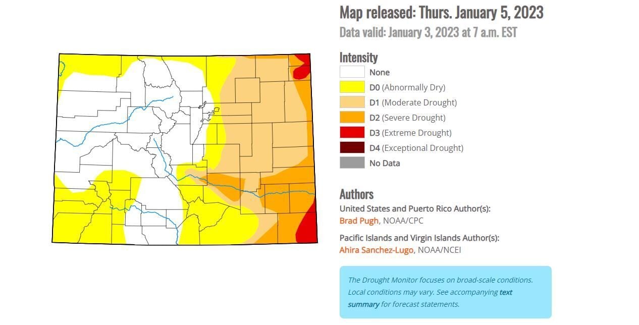
That exceptional drought in those area is now nearly nonexistent, and D3, or extreme drought, exists only in those two counties, plus a small portion of Prowers County and about half of Baca County, both in southeastern Colorado.
The Front Range, which saw 7 inches in most areas of heavy, wet snow to close out 2022, helped push the December average to record levels. At Denver International Airport, the snowfall during those last few days contained about 0.67 inches of rain and snowmelt, which is more than the area usually gets in December and January combined.
El Paso County also saw dramatic improvement in the past week, with severe drought conditions on the county’s east side all but gone.
In the Colorado Springs area, December was a fairly wet month with a half inch of precipitation, which is .27 inches above normal, according to the National Weather Service.
Get OutThere
Signup today for free and be the first to get notified on new updates.
PREV
PREVIOUS

Democrats keep memory of Jan. 6 alive as party looks ahead to 2024
The Democratic Party is keeping the memory of Jan. 6, 2021, from fading in a bid to cast Republicans as foes of good governance who would rather sow political chaos than deliver for voters. President Joe Biden marked the second anniversary of the Capitol ransacking Friday with a White House ceremony recognizing law enforcement who […]

Trump-era ban on bump stocks struck down by court
A Trump-era ban on bump stocks, devices that enable semi-automatic weapons to fire multiple rounds quickly, was nixed by a federal appeals court in New Orleans on Friday. The ban was imposed after the deadly 2017 Las Vegas mass shooting that killed dozens under the premise that bump stocks convert semi-automatic weapons into machine guns, […]