


Snowpack booms past 30-plus-year high in Colorado region
Southwest Colorado has officially broken a snowpack record that’s stood since at least 1987.
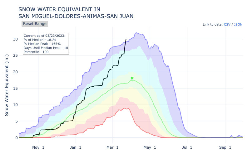
As of March 23, snowpack in the San Miguel-Dolores-Animas-San Juan river basin is at 29.9 snow water equivalent inches, according to the USDA. Not only is this 181 percent above the 30-year median, it’s also the highest it’s been on this date since at least 1987. Prior to that, data wasn’t as thorough, making it difficult to compare to previous decades. In other words, there’s a chance this record stood for even longer.
The 29.9 inches of snow water equivalent compares to a previous record high in this region on March 23 of 29.2 inches. Now, the region is closing in on the record peak high of 32 snow water equivalent inches, recorded on April 9 of 1993.
April 2 tends to be the date of peak snowpack in this region, which means there are still plenty of days left where snowpack is expected to increase based on the 30-year norm. In particularly snowy years, the peak is often past this date, further increasing the chances that this maximum snowpack record falls.
While the most recent snowstorm that walloped the region is tapering off, another chance of steady snow could start on Friday, with more snow possible on Sunday, and more snow possible next week.
Elsewhere in Colorado, the only region that has been lagging behind the 30-year median in terms of snowpack, the Arkansas River basin of the southeast, has caught up to the median in recent days. This part of the state now sits at 98 percent of the 30-year median, with all other regions currently having a snowpack above the norm.
Here’s a breakdown of how each region is doing compared to the 30-year median.

STAY INFORMED: Get free Colorado news with our daily newsletter (Click here)
Get OutThere
Signup today for free and be the first to get notified on new updates.
PREV
PREVIOUS

Vibrant flavors served up at Roadrunner Pizza & Pasta in Colorado Springs | Dining Review
The nondescript, mostly vacant strip mall where Roadrunner Pizza & Pasta has been dishing up pies and more for 40 years belies the vibrant flavors produced from its diminutive storefront. Roadrunner’s small neon signs are among the limited evidence of life in the Venetian Village shopping center on North Hancock. There’s plenty of parking, so […]

Wild 'dome-shaped' home in Colorado featured on viral 'Zillow Gone Wild' page
A home in Colorado is getting quite a bit of attention after being featured on the popular ‘Zillow Gone Wild’ social media accounts. In less than 24 hours, more than 17,000 people have reacted to the posting of a dome-shaped home in Castle Rock that’s definitely capable of turning heads. With the official listing for […]