


Colorado weather: Tornado, pea-sized hail near Denver airport
Winter Storm Warnings are in effect for the Front Range Mountains and Foothills and Palmer Divide
Colorado weather forecasters are tracking a powerful storm on Tuesday that has already produced a landspout tornado and is expected to bring heavy snow and rain to other parts of the state.
The landspout tornado, the first in Colorado this year, touched down around 3 p.m. near Keenesburg, according to The Denver Gazette’s news partners, 9NEWS.
The tornado lifted by 3:15 p.m., although it had been visible from Denver International Airport, 9NEWS reported, and inbound flights were held until 4:15 p.m.
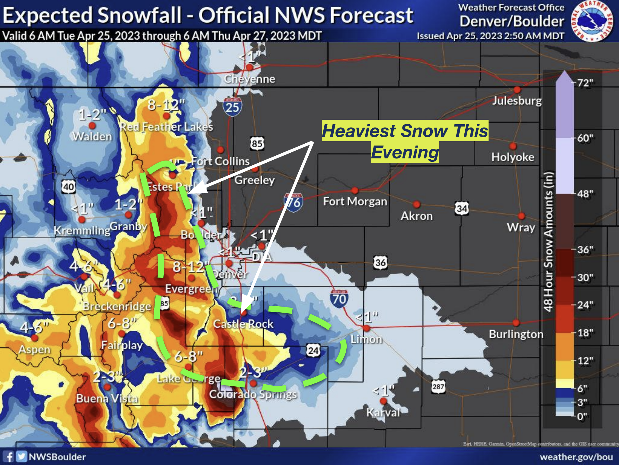
The National Weather Service says a winter storm warning is in effect for the Front Range Mountains and Foothills through noon on Wednesday. This includes Red Feather Lakes, Estes Park, Evergreen and Castle Rock.
One to two feet of snow are possible, especially above 8,000 feet, with higher amounts possible in some spots, the weather service said.
The weather service said snow will fall at a rate of 1.5 to 2.5 inches per hour during its heaviest times.
Areas along the I-25 corridor will mostly see rain. A half inch to an inch is possible with lower amounts falling north and east of Denver, the weather service said.
The weather service said in Denver the rain could turn to snow overnight, with a low of 33 degrees expected. However, only about a half-inch of accumulation is expected in the city.
However, snow is possible along the I-25 corridor south and west of Denver.
A Winter Storm Warning is also in effect over the Palmer Divide from 6 p.m. Tuesday through noon Wednesday, when the weather service says 5 to 13 inches of snow is possible. The snow could pile up at a rate of 1.5 to 2.5 inches per hour at its heaviest times.
Drivers should expect major effects in the foothills between 6,000 and 9,000 feet and along the U-285 and I-70 corridors after 6 p.m. on Tuesday, when heavy snow is expected, the weather service said.
Roads were expected to be covered in ice, slush or snow in the Foothills, Palmer Divide and US-285 and I-70 corridors overnight, with conditions beginning to improve Wednesday morning, the weather service said.
The weather service advised motorists to check road conditions before heading out, pack an emergency supply kit and make sure their vehicle is ready for adverse conditions.
This story will be updated as more information becomes available.