


Flooding expected to close 51-mile stretch of Colorado highway
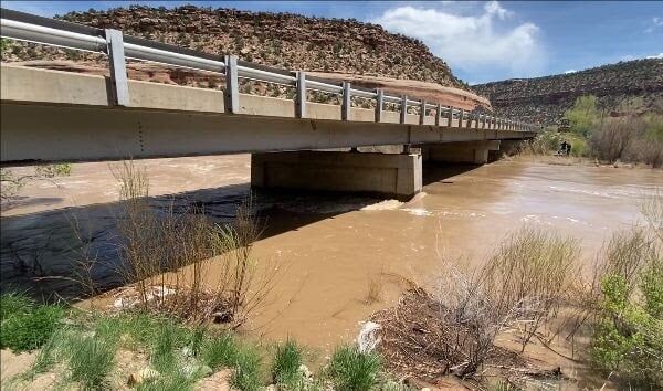
An approximately 51-mile stretch of Colorado Highway 141 is expected to close on Friday evening, as the area prepares for high river flows and potential flooding, according to an announcement by the Colorado Department of Transportation (CDOT).
The department is planning to close the highway between Naturita and Gateway at approximately 5 p.m. The total duration of the closure has not yet been estimated, but officials say that it will continue until flood danger subsides.
The bridge at Roc Creek, located approximately 27.5 miles north of Naturita at Mile Point 88.5, will also be closed to traffic during “peak water flows”.
“River flows in the area have not been observed at these levels in 18 years. With the flood event expected to peak this Friday, we are taking proactive and cautionary measures at this particular bridge. Engineers and maintenance personnel will be assessing the structural integrity throughout this high-flow event,” stated Julie Constan, Regional Transportation Director in the announcement.
According to CDOT, snowmelt and reservoir releases are playing a role in high river flows.
” The National Weather Service (NWS) has issued a flood advisory for the Dolores River due to the increased release of water from McPhee Reservoir. The flood advisory also includes the Dolores and San Miguel Rivers due to heavy runoff from snowmelt,” CDOT reported.
Montezuma, Dolores, San Miguel and Montrose counties have been included in the advisory area.
STAY INFORMED: Get free Colorado news with our daily newsletter (Click here)
Get OutThere
Signup today for free and be the first to get notified on new updates.
PREV
PREVIOUS

How to appeal your Colorado home property value assessment
Any property owner can protest their home value assessment that counties in Colorado sent out last week, but the deadline in June 8
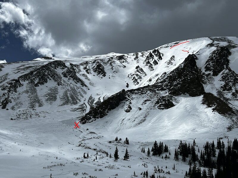
Fatal avalanche carried skier 1,700 feet down peak near Breckenridge
The official report related to a fatal avalanche that took place near Breckenridge on April 29 has been released by the Colorado Avalanche Information Center. It details a slide that killed a solo backcountry tourer, carrying him 1,700 feet downhill before leaving him buried about two feet under the surface of the snow. The slide took […]