


Whiteout daily snow report, Feb. 5

Your Monday morning moment of ZEN:
The Groundhog Day weekend storm brought between 10-30 inches of snow to Colorado, in spite of predicting an early spring.
The temperatures on Friday into Saturday were warmer, making for denser falling snow, but the air cooled on Saturday into Sunday morning and the snow dried out, creating fluffier snow on top of soft snow. This made the skiing and riding on Sunday very good in the northern, western and central mountains. Beaver Creek (15″) received a surprise shot of snow for Sunday and reported the highest total for the day.
Monday’s weather will be dry and sunny before increasing clouds make their way into southwestern Colorado as the next, moisture heavy, storm enters the state Tuesday, with snow beginning to fall late day.
The ECMWF high resolution model forecasts snow to begin in the San Juan mountains Tuesday and spread northeastward throughout the afternoon into the evening. However, the storm will stay mostly in the western areas of the state.
Wednesday is forecast to be a day with heavy snow and 10-20 inches of accumulation piling up. The southern resorts should have a powder afternoon on Wednesday and Thursday. Softer conditions in the western and central mountains look favorable as well, with 4-6 inches possible for Thursday’s first chairs.
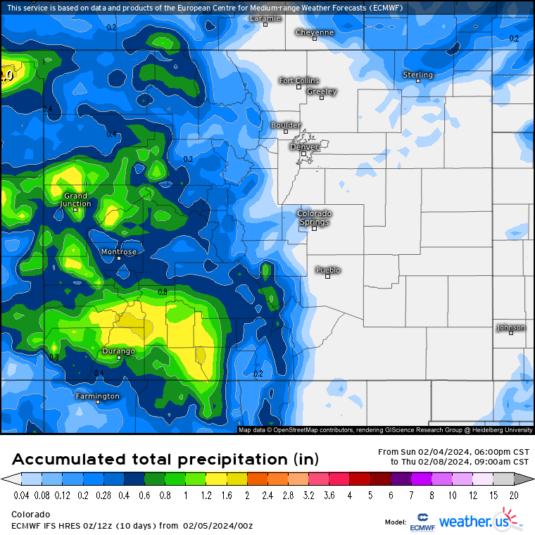
The northern resort are forecast to receive a 2-4 inch shot by Thursday morning but the winds will be from the south and southwest, usually creating less than ideal conditions for orographic up lift and moisture mixing to give these areas ample snow amounts.
Thursday night into Friday the European model forecasts some more bands of snow lingering around the northern San Juan mountains and Grand Mesa and West Elk mountains, augmenting the accumulations another 3-6 inches by Friday’s first chairs.
The upcoming weekend has potential for more snow throughout Colorado as well. More details will emerge as the storm system nears the state.
Today’s 24 hour snow total from Colorado resorts:
Arapahoe Basin – 0″
Aspen Mountain – 1″
Aspen Highlands – 1″
Beaver Creek – 0″
Breckenridge – 0″
Buttermilk – 1″
Cooper – 0″
Copper Mountain – 0″
Crested Butte – 0″
Echo Mountain – 0″
Eldora Mountain – 0″
Granby Ranch – 0″
Hesperus – Closed for season
Howelsen Hill – 0″
Kendall Mountain – 3″, open weekends
Keystone – 0″
Loveland – 0″
Monarch – 1″
Powderhorn – 0″
Purgatory – 0″
Silverton – 0″
Snowmass – 2″
Steamboat – 0″
Sunlight – 0″
Telluride – 0″
Vail – 0″
Winter Park – 0″
Wolf Creek – 3″