


New storm is only 3 days away for Colorado : Whiteout daily snow report, Feb. 29

If the Tuesday ‘snow storm shot in the arm’ didn’t cure your powder bug, wait only three more days for a second booster, because Colorado’s about to get double vaccinated.
Recap:
On Wednesday, the sun came back out minus some high passing clouds in northern Colorado and high temperatures rebounded into the high 20s and low 30s. Powder shots from Snowmass looked rather ZEN:
Forecast:
Similar sunny skies, yet warmer temperatures into the upper 30s and low 40s, is forecast for Thursday, Friday and Saturday ahead of the next storm.
Colorado’s weekend storm is forecast to come ashore in northern California on Thursday morning, bringing the potential for snow accumulations to the Sierra Nevada mountains between 4-8 feet and perhaps upwards of 10 feet above 5,000 feet in elevation.
The ECMWF high resolution model forecasts snow showers to start around 7 p.m., Saturday in northwestern Colorado.
Snow will ramp up overnight into Sunday and by first chairs around 8:30 a.m., 4-12 inches for the western and northwestern mountains, and 2-5 inches is forecast for the northern and central mountains. The northern San Juan mountains may have a dusting to 2 inches. I would not be surprised if snow squall warnings are issued on Sunday morning for similar locations in the western, central and northern mountains.
Snow is forecast from the European model to continue throughout Sunday into as late as Monday afternoon, but other models, including the American GFS and German ICON model, have snow accumulations higher in other mountain zones.
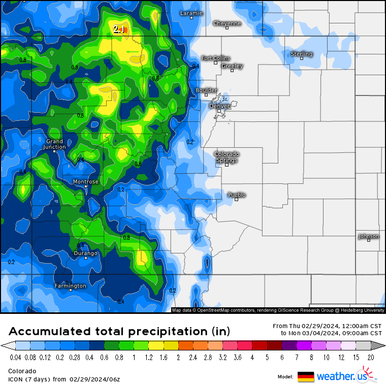
Snow accumulations by Monday’s first chairs could range between up to 24 inches around the Grand Mesa, 12-16 inches in the Flattops and Park (Steamboat) and Elkhead mountains, and 4-12 inches for most other northern mountains north of Interstate 70 and the northern side of the central mountains (Aspen/Snowmass and Sunlight).
Like with prior forecasts, this model run will most likely change along with snow totals. The storm will be pushing moisture into Colorado on the atmospheric river from the southwest and depending on moisture levels, orographic lift and wind direction, snow could potentially equate to early models or fizzle out similar to Tuesday’s storm expect for isolated spots like Snowmass, Aspen and Ski Cooper saw.
Long Range:
For Tuesday and Wednesday, drier weather returns for a brief 48ish-hour period before more storminess enters back into Colorado around Thursday with Friday forecast to be the storm day.
Today’s 24 hour snow total from Colorado resorts:
Arapahoe Basin – 1″
Aspen Mountain – 0″
Aspen Highlands – 0″
Beaver Creek – 0″
Breckenridge – 0″
Buttermilk – 0″
Cooper – 0″
Copper Mountain – 0″
Crested Butte – 0″
Echo Mountain – 0″
Eldora Mountain – 0″
Granby Ranch – 0″
Hesperus – Closed for season
Howelsen Hill – 0″
Kendall Mountain – 0″, open weekends
Keystone – 0″
Loveland – 0″
Monarch – 0″
Powderhorn – 0″
Purgatory – 0″
Silverton – 0″
Snowmass – 0″
Steamboat – 0″
Sunlight – 0″
Telluride – 0″
Vail – 0″
Winter Park – 0″
Wolf Creek – 0″