


Colorado Trail: 6 segments every mountain biker needs to experience
If you can't bike all 28 segments of the Colorado Trail, these 6 will satisfy.

The Colorado Trail can be measured in three lengths — 486 miles, 491 miles or 549 miles — depending on which route you take.
It consists of 28 segments of mixed single-track, forest roads and rocky traverses from Denver to Durango. Each segment has its own personality, challenges, mystique and vistas waiting for riders to experience on this uniquely-Colorado trail system.
Experiencing some or all segments via mountain biking or “bikepacking” gives riders a different perspective from the traditional hiking or backpacking experience on the trail.
My favorites: 6 Colorado Trail segments you should bike:
Segment 2 — South Platte River to Little Scraggy
Of the three segments closest to Denver, Segment 2 might be the most interesting segment to ride. A mix of climbing, flowing flats and small descents, the South Platte River segment starts at the South Platte River’s banks and climbs almost non-stop for the first five miles, with the steepest of the climbing in the first two miles.
I mountain-biked this segment in late June, pedaling up from the Gudy Gaskill bridge and labored rather hard on the first ascent. But what was a slog to start became a sight to see upon clearing the hilltop around mile one. I’ve never been a strong climber, and this climb was more difficult than envisioned, but seeing more than 50 yards ahead of your pedal always is a sign of relief.
For the next four miles, the ride climbs not as steeply on a wide single-track, past abandoned mining vehicles on sandy and eroded wash outs through parts of the Buffalo Creek fire burn scar, topping out at 7,764 feet in elevation at mile five.
The route: 10.3 miles. Elevations: 2,175′ up, 619′ down
The second five miles are a mix of small descents and flowing flats through pine forest and open meadows; a fast and fun flow before reaching Segment 3’s trailhead at Little Scraggy.
Biking fun factor rating: 4.1/5
Segment 26 — Bolam Pass Road to Hotel Draw Road, in reverse
John Muir, known as “John of the Mountains” and “Father of the National Parks,” once said, “The mountains are calling, and I must go.” I wonder if he would have gone more often with a full suspension mountain bike. He surely would have if he knew about Segment 26 of the Colorado Trail.
Nestled northwest of Purgatory Ski Resort and high above Hermosa Creek, Segment 26 is arguably the most scenic and most fun segment on the entire Colorado Trail.
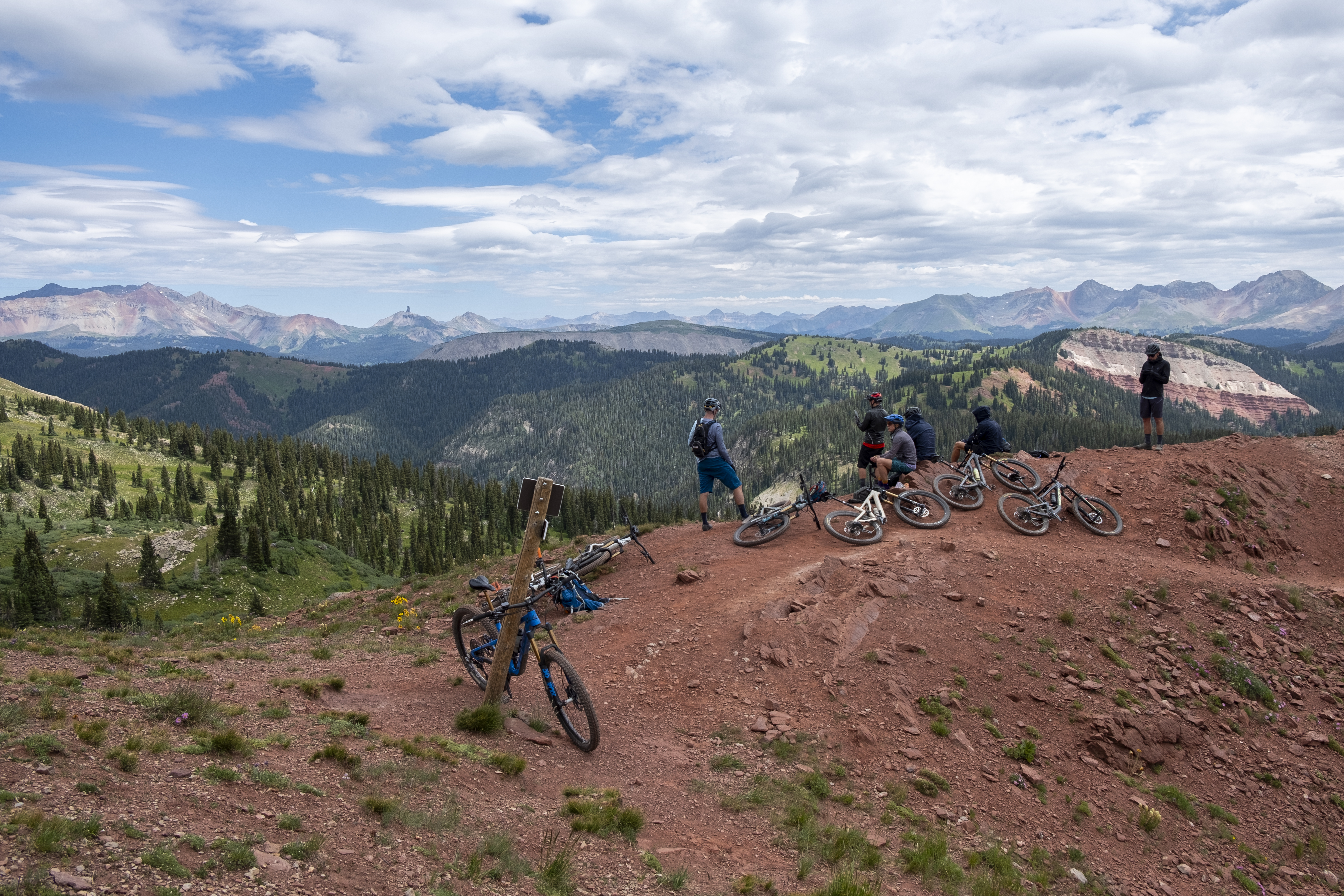
I decided to ride Segment 26 in reverse, climbing up from Hotel Draw Road near Segment 27’s start, in order to crest Blackhawk Pass from the south. This route was truly epic.
Out of the 13 segments I biked, this one was hands down the best, with the reward being amazing views of the Wilson group, Lizard Head, Mt. Sneffels and San Joaquin Ridge, among several new biker friends at 11,983 feet.
The route: 11.3 miles. Elevations: 2,644′ up, 4,530′ down
The nearly all uphill pedal from Hotel Draw Road was smooth, firm single-track dirt all the way to treeline around mile 3. The last mile of trail to Blackhawk Pass was just as great, with a short hike-a-bike section near the top due to the steepness.
However, 50 feet from the top, the trail levels and the northern San Juans began to show, with the Wilson group looking God-like in the late morning light.

Knowing I had climbed a dash over four miles, the descent back down was going to be fast, and it was, taking only 20 minutes, which felt conservative since the trail felt immaculate and tacky beneath my tires.
Fun factor rating: 4.9/5
Segment 8 — Copper Mountain to Tennessee Pass
Arguably the crown jewel of the first 10 segments of the Colorado Trail, Segment 8 has a ton to offer riders doing either a mountain bike ride or bikepack. From cresting two alpine mountain passes (Searle and Kokomo) to pedal-touring the former U.S. Army’s 10th Mountain Division training facility at Camp Hale to passing by eroding cooking ovens from Colorado’s mining era, this segment offers lots of history while being one of the hardest, but stunningly scenic, rides of the Colorado Trail system.

I decided to dabble a section of this segment, starting at Camp Hale around 9,300 feet, and ascend south to Tennessee Pass for a seven-mile, one-way climb before descending back. Passing by munitions bunkers at the East Fork of the Eagle River bridge crossing, the crumbling remains stand true, with the trail steadily climbing up some of the best single-track of the trail system through pine and aspen forest, with a possible camping spot about one mile up for weary bikepackers.
After crossing U.S. Hwy 24 around mile 21.6, the trail flattens its ascension, passing riders through a high meadow before a long stretch of abandoned railroad grade climbs toward Tennessee Pass. The old cooking ovens are about 0.5-miles from Tennessee Pass, offering a glimpse into Colorado’s mining era.
The route: 25.8 miles. Elevations: Seg. 8, 4,153′ up, 3,494′ down or 7 miles from Camp Hale, 989′ up, 989′ down
This shortened section was top-notch: Easy pedaling over smooth single-track, nearly no hike-a-bike sections or technical spots and a fast and amazing downhill return due to nobody hiking or biking up from Camp Hale.
Biking fun factor rating: 4.6/5
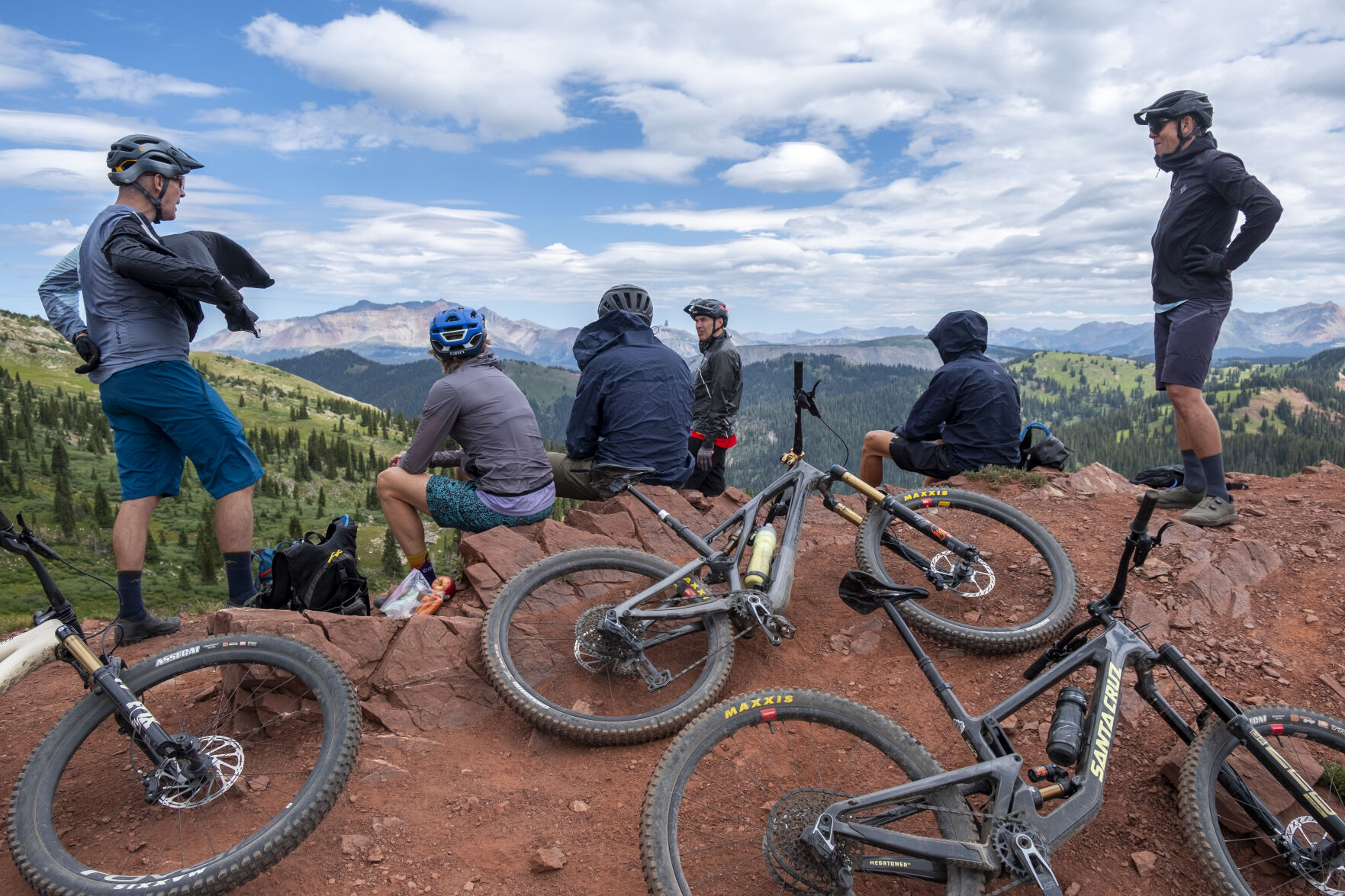
Segment 25 — Molas Pass to Bolam Pass Road
The San Juan Mountains arguably claims the title “Most-Scenic Range” in Colorado, and exploring them by foot or bike is the best way to see and experience their awe.
At the Segment 25 trailhead atop Molas Pass, jump on your bike and pedal westward toward Little Molas Lake before ascending some of the best well-maintained single-track on the Colorado Trail. You might even see pack llamas.

I decided to start at Little Molas Lake for my day ride on Segment 25. Recent work to a few eroded sections around Mile 2 have kept this section of trail in great shape since it is popular due to its easy access from Hwy 550.
Similar to Segment 26 (Bolam Pass to Hotel Draw), the trail is above treeline for a majority of the entire length, but the views of the surrounding peaks are visible nearly at every turn.
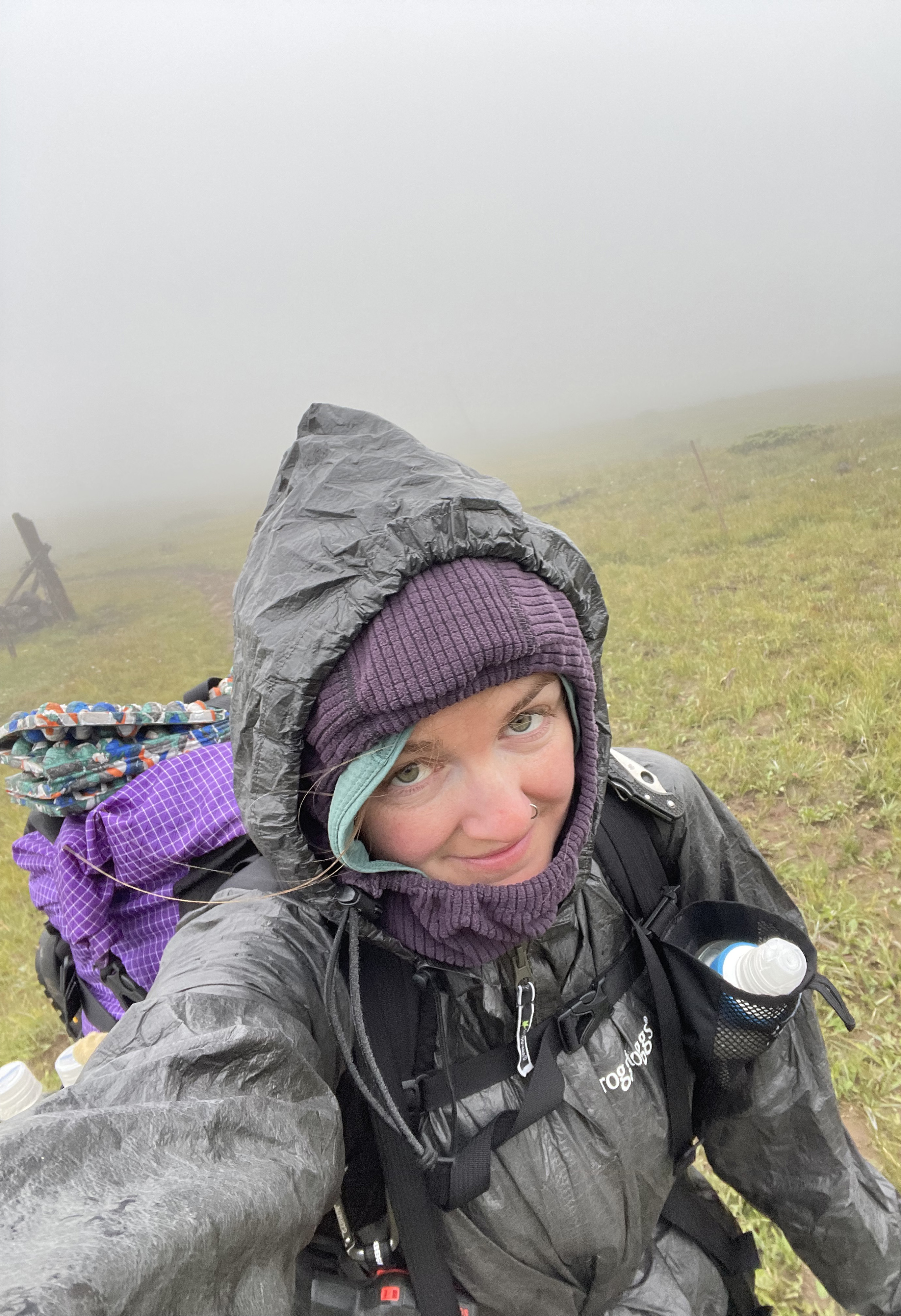
The high point of the segment is at 12,505 feet around mile 11. But for my ride, I only was able to enjoy the first four miles because a storm moved in sooner than expected and I wanted to catch back up to the llamas I had passed around mile three.
Monsoon rains can build quickly in the high-country, and today’s ride was no different. Sprinkles began falling around 10 a.m., and being wet and cold above treeline, even in summer, is no fun. Plus, I really wanted to capture and experience being around the llamas one more time before they concluded their hike back to the trailhead at Little Molas Lake.
The route: 20.5 miles. Elevations: 3,240′ up, 3,030′ down
A great bikepacking campsite with a view is around Mile 5 and a waterfall at Cascade Creek at Mile 14.6 is another sight-to-see on this spectacular segment.
Fun factor rating: 4.7/5
Segment 11 — Mount Massive to Clear Creek or Twin Lakes Trail loop
Alpine lakes are abundant along the Colorado Trail, but Twin Lakes Reservoir just south of the Twin Lakes township is the largest body of water travelers pass while on the Colorado Trail. Part of Segment 11 shares trail with the Twin Lakes Trail loop as an incredible complimentary ride that circumnavigates Twin Lakes Reservoir, including a tour through the Interlaken Historical Site on the south shores of the lakes.
Starting at Twin Lakes township, the ride travels east on US Hwy 82 for approximately two miles before joining the Colorado Trail. A flowy, but sandy, single-track follows the north shores of Twin Lakes Reservoir for four miles before turning south at the dam crossing.

I decided to mountain bike the entire Twin Lakes Trail loop, including the ever-so Not-Very-Fun Willis Gulch Connector trail — a quarter-mile long, hike-a-bike death-march — up over a rocky precipice on the western side of the loop.
Before suffering Willis Gulch, however, the Twin Lakes Trail loop follows the south shores through rolling single-track, including past the Interlaken Historical Site, where you can enter and explore several 19th century buildings like the Dexter Cabin, before continuing westward back toward Hwy 82 and Twin Lakes township.
The route: 21.6 miles. Elevations: Seg. 11, 2,361′ up, 3,490′ down or 14.8 miles, Twin Lakes Trail loop, 605′ up, 605′ down
The June 2024 Interlaken Fire burned trees and grasses for approximately 1.5 miles along the south shore of Twin Lakes Reservoir all the way to lake’s edge. If you’ve never biked through a burn scar, it is truly an unique and unearthly experience.
Biking fun factor rating: 4.4/5
Segment 17 – Sargents Mesa to Hwy 114
Wandering the forest like Hansel and Gretel on Segment 17 feels like the Colorado Trail has abandoned you, but without the creepy witch chasing you. Yet this segment is one of six where you start becoming “very remote” after leaving Segment 15 and the comforts of U.S. Highway 50 near Monarch Pass — and that’s a good thing.
One unique feature to start your bike ride on Segment 17 is a visit to Soldierstone — the Vietnam War memorial 0.2 miles south of where Segment 16 turns into 17. The gray monolith stands 12-feet tall among the high meadows atop Sargents Mesa, offering a sense of melancholy when viewing the pillar and its surrounding stones engraved with words and sayings in multiple languages, honoring all fallen soldiers from the war.

On the trail, however, the technical riding over and around rocks and rock gardens is kind of fun and challenging, as the trail travels west toward Highway 114. The high point, at 11,685 feet on Long Branch Baldy’s slopes, is a good turnaround spot — about 7.4 miles — back to Sargents Mesa if day-riding, which was what I did.
The route: 20.9 miles. Elevations: 2,644′ up, 4,530′ down
Segment 17, which has a lot of beetle kill among the trees, is generally on south facing slopes, making the ride “warmer,” yet staying above 10,500 feet for over half the ride. Not all of it is hot and your pedal-in-the-woods will still be fun.
Fun factor rating: 4.3/5
Get OutThere
Signup today for free and be the first to get notified on new updates.
PREV
PREVIOUS
Colorado Trail: Sick, cold and stranded
An emergency in the night, and the deliverance in being well-prepared

Denver weather: Thursday cools as temperatures drop toward seasonal averages
A break from well above-average temperatures on Thursday will be courtesy of an afternoon cold front blowing into Colorado. Denver residents can expect a sunny skies, with a high near 73, according to the National Weather Service in Boulder. South winds to blow between 7 to 11 mph, will become north northeast in the morning. […]