


Second wave of ‘hurricane-esque’ snow storm to add another 12-18 inches in Colorado | Whiteout snow report
Powder skiing at Wolf Creek rest of week, northern mountains Friday and Saturday
Round two of Colorado’s ‘hurricane-esque’ snowstorm is currently ongoing.
Eldora opens today, the rest of Summit County (Copper and Breckenridge) and Winter Park will be open Friday, Loveland opens Saturday, and more snow continues into the weekend.
The second wave from the prolonged winter storm will continue to lay large amounts of snow across the state through Saturday.
Plus, to skiers’ and riders’ delight, more snow is forecast for the middle of next week.
Recap:
On Wednesday, it was a light powder day at Keystone and Arapahoe Basin in the northern mountains, however, Wolf Creek riders were rewarded with 14 inches of fresh snow, bringing the southwestern Colorado resort to 55 inches of recorded snow for the season.
Snow showers continued mostly south of Interstate 70 throughout the morning, but tapered off in the afternoon, except in southern Colorado; it was still snowing at last chair at Wolf Creek.
The snow picked back up again in the late afternoon and after sunset, with upsloping winds from the north and northeast, pushing more moisture into the Front Range foothills from Boulder County to Trinidad.
Forecast:
On Thursday, the ramping back up of the ‘hurricane-esque’ looking cut-off low-pressure system will force more moisture into Colorado’s southwestern and southeastern mountains.
Here is the satellite imagery loop of the storm from the GOES-16 satellite:
Here is the ECMWF 500 mb Height (dam), Wind (kt) forecast model of the storm:
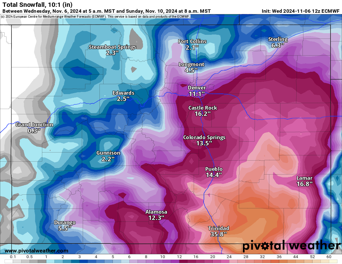
New accumulated snow totals in the southwestern mountains from the ECMWF Total snow 10:1 (in) forecast model show between 6-10 inches in the western San Juan Mountains (Purgatory, Silverton, Telluride) and 12-20 inches in the eastern San Juan Mountains (Wolf Creek).
Accumulations in the southeastern mountains — Sangre de Cristo and Wet Mountain ranges — are much higher, with totals between 8-18 inches on the west side of the Sangre de Cristo and between 20-35 inches on the east side and in the Wet Mountains, plus the backcountry west of Trinidad.
The central mountains are forecast for between 2-4 inches west of the Sawatch Range and 3-6 inches east of the Sawatch. The northern mountains are forecast for between 1-4 inches west of the Continental Divide and 4-12 inches east of the CD.
Snow showers will taper off Saturday and the storm system will clear out onto the Plains.
Long Range:
On Sunday and Monday, skiers and riders can expect sunny skies and warming temperatures for Colorado to go along with several ski areas now open. Fortunately, high pressure will only build in for a quick 48 hours before the next storm arrives.
For Tuesday and Wednesday, the forecast calls for a faster-moving storm clipping the northern part of the state above the high-pressure ridge.
Snow accumulations from this storm are currently forecast to be mostly in the northern mountains, with between 2-5 inches, mostly in the Park and Rabbit Ears ranges, although the Medicine Bow and northern Front Range mountains could pick up some snow too.
More details will be hashed out with more model runs over the next few days and more accurate snow totals will be known.
Today’s 24-hour snow totals from Colorado resorts:
Arapahoe Basin – 0″
Aspen Highlands – Closed for the season
Aspen Mountain – Closed for the season
Beaver Creek – Closed for the season
Breckenridge – Opens Nov. 8
Buttermilk – Closed for the season
Cooper – Closed for the season
Copper Mountain – Opens Nov. 8
Crested Butte – Closed for the season
Echo Mountain – Closed for the season
Eldora Mountain – 0″
Granby Ranch – Closed for the season
Hesperus – Closed for the season
Howelsen Hill – Closed for the season
Kendall Mountain – Closed for the season
Keystone – 0″
Loveland – Opens Nov. 9
Monarch – Closed for the season
Powderhorn – Closed for the season
Purgatory – Closed for the season
Silverton – Closed for the season
Snowmass – Closed for the season
Steamboat – Closed for the season
Sunlight – Closed for the season
Telluride – Closed for the season
Vail – Closed for the season
Winter Park – Open Nov. 8
Wolf Creek – 8″