


3+ feet of snow forecast in Colorado ahead of Thanksgiving, Black Friday | Whiteout snow report
Major winter storm to impact state's mountains
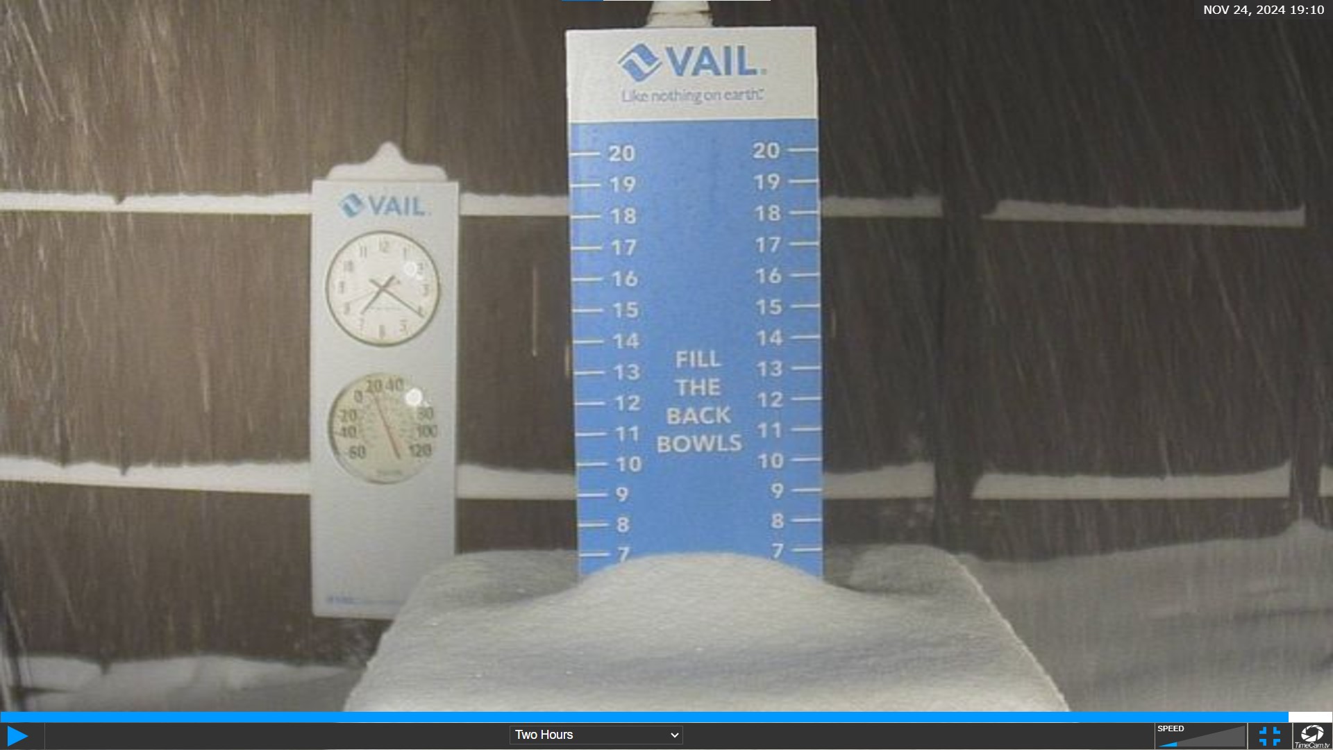
Skiers and riders, it’s a powder day here in Colorado! Hopefully you are getting a first chair today.
Colorado’s ski slopes starts off the Thanksgiving week with fresh snow at several resorts along Interstate 70, up at the Continental Divide, east of the Divide and as far south as US Hwy 50. Vail’s Back Bowls were showing 6 inches of snow around 7 p.m., Sunday night.
The second, stronger storm starts late Monday into Tuesday and winds down late Wednesday night, with between 12-36 inches forecast across Colorado.
Recap:
Saturday was sunny, Sunday started sunny, but went to snowy before noon as round one of snow starting falling in the mountains.
Snow moved in on a west to east flow, starting on the Grand Mesa around 10:30 a.m., at Snowmass around 11:30 a.m., 2 p.m. at Vail and 5 p.m. at Monarch.
Snowfall totals in the northern mountains range between 2-9 inches, in the central mountains 2-7 inches and in the southern mountains 1-3 inches.
Forecast:
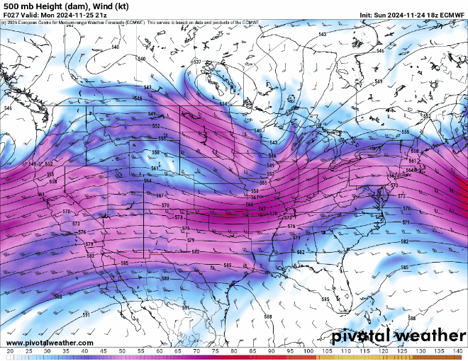
On Monday night, the ECMWF forecast model shows a zonal flow of west to east winds will push through Colorado, bringing in ample moisture from Arizona and give the state its first snow of round two.
On Tuesday, as more moisture funnels into the state on strong winds, snow accumulations will ramp up throughout the day, night and into Wednesday morning. Tuesday will be a storm day, with heavy snow at times.
The National Weather Service offices in both Boulder and Grand Junction have issued winter storm watches from Monday evening to late Wednesday night with varying snowfall totals from 7-34 inches.
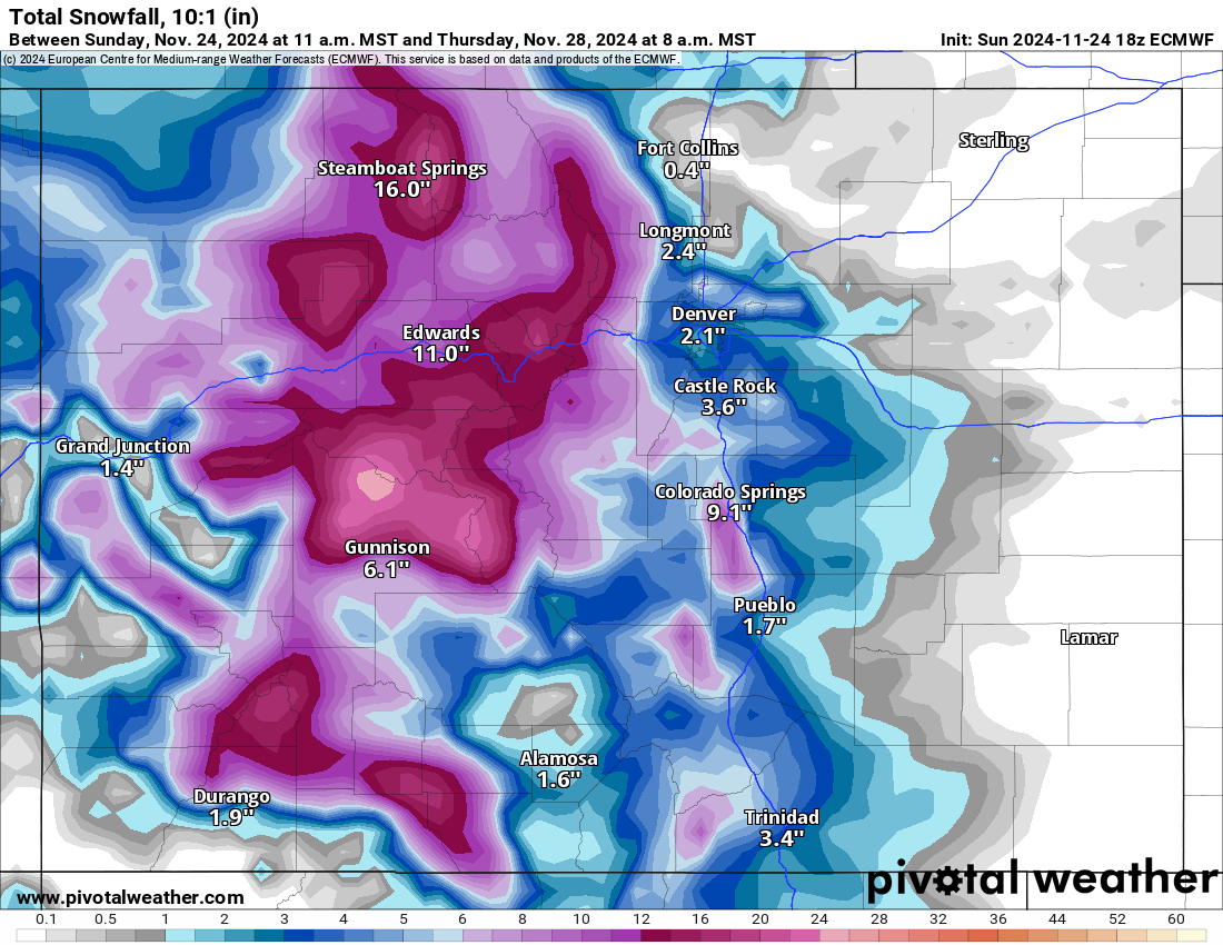
Depending on which model holds the most true, a conservative forecast estimate from the European model still has between 12-28 inches of snow accumulating by Thanksgiving morning.
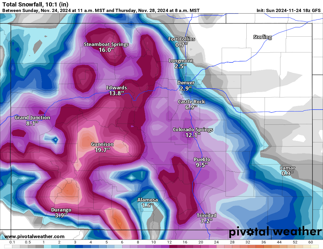
On the most liberal forecast, the NWS Blend of Models forecasts several mountain locations to receive between 24-52 inches, while the GFS model forecast somewhere around the middle with between 8-36 inches, but more snow south of I-70 (20-36″) and less snow north (8-16″).
The ECMWF model:
The GFS model:
The NWS Blend model:
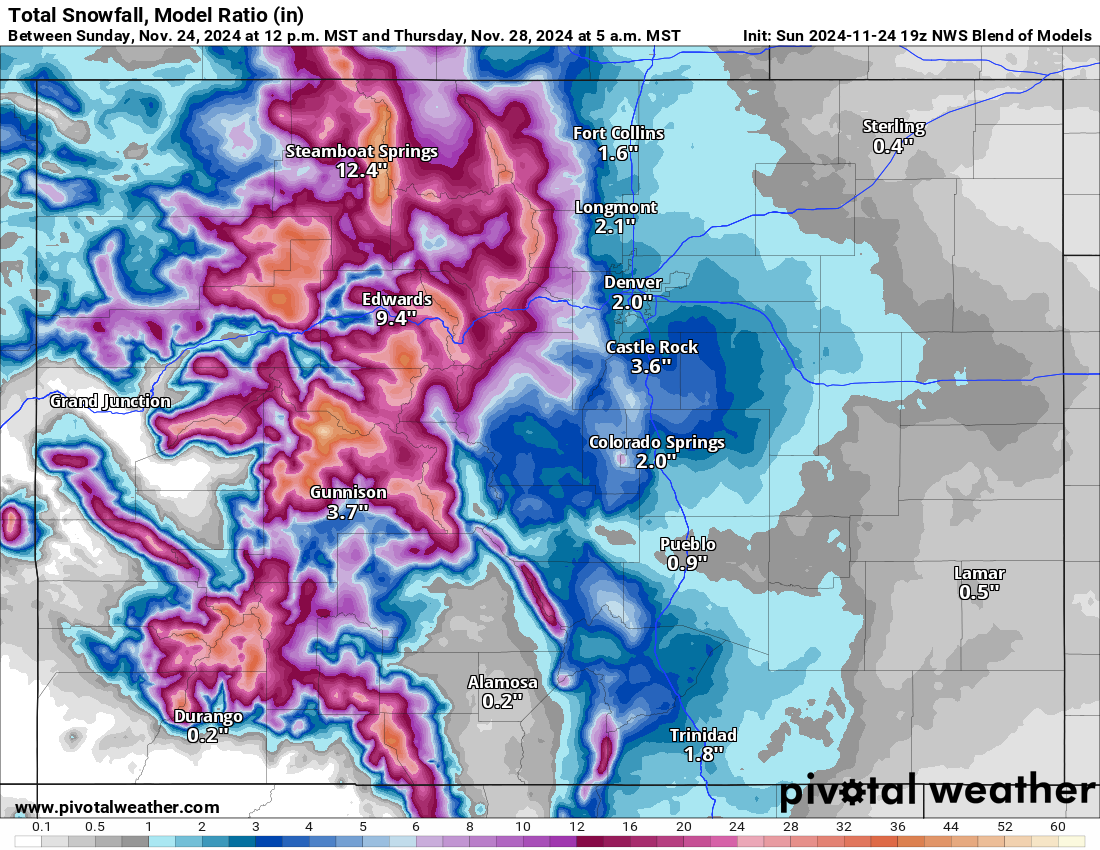
Snowfall totals by Thanksgiving first chairs for the northern mountains should be between 18-30 inches, in the central mountains 20-36 inches and in the southern mountains between 18-36 inches.
So what’s feeding this two-part storm system?
The Bomb Cyclone off the coast of Oregon and Washington that brought several feet of snow to the Sierra Nevada and Cascades ranges last week eventually broke down, however, it wobbled southward enough to help re-channel the atmospheric river across central California and eventually into Colorado.
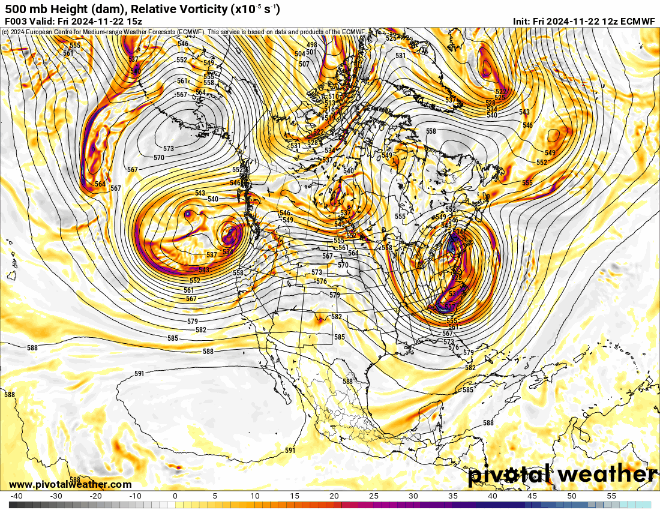
The above ECMWF Relative Vorticity forecast model loop shows the two low pressures systems associated with the Bomb Cyclone in the Pacific Ocean spinning around one another before the southern system falls apart some, but is pushed on shore from the northern system, which helps funnel the atmospheric river into Utah and Colorado.
The atmospheric river will last through Wednesday before drier air will pull in behind it for Thanksgiving Day.
Temperatures associated with this storm from the NWS are forecast to remain on the higher side, with daily highs between 25-30 and nightly lows in the teens both Monday and Tuesday.
On Wednesday night, temperatures will drop to close to 0 as the storm system exits into the Midwest.
Long range:
On Friday and Saturday, a chance of snow is in the forecast, with Arctic air dipping into Colorado from the northwest. This system is currently forecast to clip the northern and northeastern parts of the state, bringing potential snow accumulations mostly north of I-70 and east of Steamboat to Crested Butte.
More details from this storm will become more clear as the models perform more runs and the dates near.
Today’s 24-hour snow totals from Colorado resorts:
Arapahoe Basin – 5″
Aspen Highlands – Closed for the season
Aspen Mountain – Closed for the season
Beaver Creek – Open Nov. 27
Breckenridge – 6″
Buttermilk – Closed for the season
Cooper – Closed for the season
Copper Mountain – 9″
Crested Butte – Open Nov. 27
Echo Mountain – Closed for the season
Eldora Mountain – 2″
Granby Ranch – Closed for the season
Hesperus – Closed for the season
Howelsen Hill – Closed for the season
Kendall Mountain – Closed for the season
Keystone – 8″
Loveland – 3.5″
Monarch – 1″
Powderhorn – 1″
Purgatory – 0″
Silverton – Closed for the season
Snowmass – 6″
Steamboat – 7″
Sunlight – Closed for the season
Telluride – Closed for the season
Vail – 9″
Winter Park – 5″
Wolf Creek – 0″