


Record-setting November snowstorm brings some drought relief to Colorado
Courtesy of NOAA
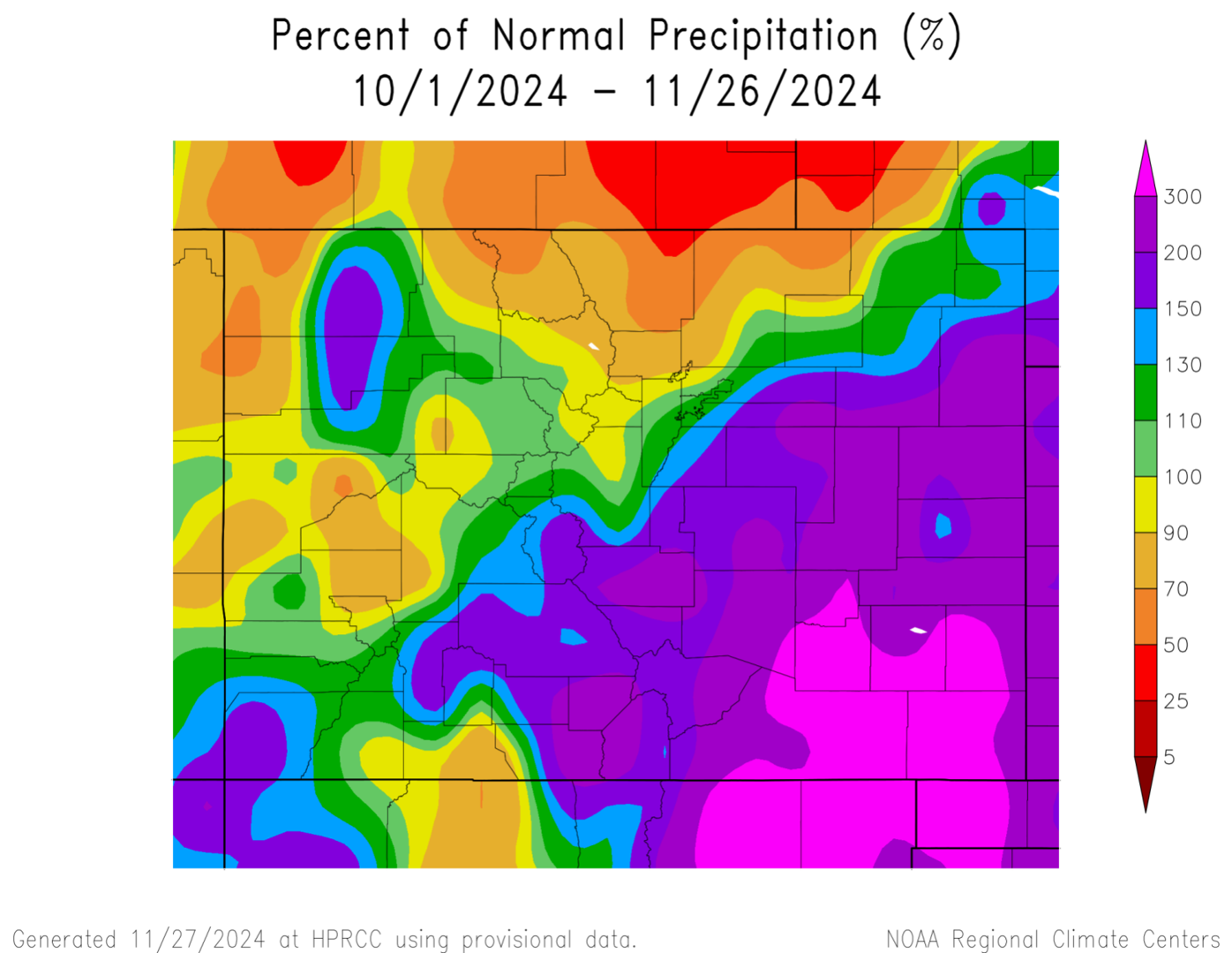
After an abnormally warm summer and fall, November’s snow has helped relieve Colorado drought conditions, particularly in the southeastern corner of the state.
The major storm that started on Election Day and set a 30-year record for November snowfall on Pikes Peak also dropped several feet of snow in the lower Arkansas Valley and across a portion of the eastern plains. Trinidad received 43 inches or nearly 4 feet of snow. For some communities that meant several inches of precipitation, well above what the region could expect from November through February, said Russ Schumacher, state climatologist.
In those communities, only one storm in 1946 topped the early November storm, he said.
For two counties on the state line, Baca and Prowers, the snow allowed them to move from severe drought to abnormally dry, according to the U.S. Drought Monitor. Such an improvement typically doesn’t happen in a single storm, Schumacher said.
El Paso County has also come out of a moderate drought to just abnormally dry since the beginning of the month through Tuesday, the monitor shows. The northern portions of the state, including the Denver Metro Area, are seeing drought conditions persist.
Across the state, the amount of land considered in drought has dropped from about 52% in October to about 42%, said Brad Pugh, the operational drought lead at NOAA’s Climate Prediction Center. He does not expect drought to develop through the end of February.
The snowstorm hitting the state just before the Thanksgiving holiday had not yet been factored into the drought monitor, but it was bringing a welcome boost with well over an inch of water in some areas on Tuesday, Schumacher said.


A map from the U.S. Drought Monitor shows conditions on Oct. 29 across the state.
“For any time of year, this is a very big storm,” he said.
But it’s still early in the season, and Colorado typically sees its critical snowpack build in the mountains later in the year. Colorado Springs, Denver and much of the eastern population centers in the state rely on snowpack for water year round.
Looking forward, the snow outlook for the coming months is more uncertain than usual because neither El Niño nor La Niña have formed, Schumacher said.


A U.S. Drought Monitor map from Nov. 26, 2024, shows how conditions have improved across the state.
But water providers are still happy with a strong start to the snow-season.
The Nov. 4 snowstorm set a 30-year record for the most snow accumulation during the month on both the North and South Slopes of Pikes Peak. The North Slope received 29 inches or about 259% of average and the South Slope received 44.3 inches or about 311% of the 30-year average, said Nick Harris, an engineer in Water Resource Planning.
While local watersheds only provide a portion of the communities’ water the whole system also looks healthy with 106% of the average amount of water for this time of year, he said.
Denver Water, which serves 1.5 million people in the metro area, also has strong numbers with 120% of the median snowpack on the South Platte and 104% of the median on the Colorado River, said Nathan Elder, manager of water supply for the utility.
“It’s been one of the better starts to the season that we’ve seen,” he said. The last time the utility had a strong start like this was in 2019.
Such heavy wet snow before the ground freezes can help recharge soil moisture and ensure that more water makes it to streams and rivers in the spring, Elder said.
The next two weeks across Colorado are expected to bring dry, warm weather, Pugh said, and the longer term outlook also reflects dry weather for southern Colorado.
But all the snowiest months, including March, lay ahead.
“There is still a long, long winter yet to go,” Schumacher said.
Contact the writer at mary.shinn@gazette.com or (719) 429-9264.

Freshmen combine for all but six points as Air Force basketball falls at Fresno State
Brent Briggeman
brent-briggeman@denvergazette.com
Updated 3 hours ago
Short-handed Fresno State shot a scorching 60% from the field in the second half and blew past Air Force 93-63 on Saturday. It will be the last trip to Fresno, California, for the Falcons in a conference game, as the...
Brent Briggeman
Reporter
No. 8 DU Pioneers hockey sweeps Omaha, secures home ice for NCHC playoffs
Tyler King tyler.king@gazette.com
tyler.king@gazette.com
Updated 4 hours ago
The road reds proved powerful once again for Denver. The No. 8 Pioneers (19-11-3, 15-6-1 NCHC) completed a weekend sweep at Omaha (10-20-0, 6-14-0) that cemented home-ice advantage in the first round of the conference tournament next month and improves...
Tyler King tyler.king@gazette.com
Reporter

Kaidan Mbereko nets season-high 38 saves as Colorado College hockey tops St. Cloud State on the road
Brent Briggeman
brent-briggeman@denvergazette.com
Updated 4 hours ago
A season-high 38 saves from Kaidan Mbereko were more than enough to help Colorado College hockey to a 4-1 victory at St. Cloud State. The win allowed the Tigers to grab four points on the road after they had fallen...
Brent Briggeman
Reporter

Nuggets’ Jamal Murray falls short at NBA All-Star 3-point contest
Vinny Benedetto
vinny-benedetto@denvergazette.com
Updated 3 hours ago
Jamal Murray won’t be adding 3-Point Champion to his list of accomplishments just yet. The Nuggets’ starting point guard scored 18 points in the first round of the competition on Saturday in Inglewood, California, which was not enough to advance....
Vinny Benedetto
Reporter
Woody Paige: Spring nears in Arizona, and Rox feel hopeful
Woody Paige
woody-paige@denvergazette.com
Updated 3 hours ago
For the Rockies, the idiom must be: Spring hopes eternal. The propitious revolutionary rectification of the Whack-A-Mole Roxbottoms has begun in Scottsdale in earnest. Could the long, maddening Monfort nightmare be over for intrepid Colorado Rockies baseball fanatics? Finally, responsible...
Woody Paige
Reporter

From decrepit to opulent: How 20 years of the Ellie Caulkins Opera House has elevated Denver
John Moore
john.moore@denvergazette.com
Updated 7 hours ago
Celebrating two decades since downtown finally got a worthy home for opera, ballet, concerts and more People forget what life was like before the Ellie Caulkins Opera House. When opera fans had to head down to the basement to find...
John Moore
Reporter

Colorado State storms back to beat Wyoming for third straight win
Tyler King tyler.king@gazette.com
tyler.king@gazette.com
Updated 3 hours ago
FORT COLLINS — On an afternoon where Colorado State honored a handful of program legends, Jase Butler did his best Jalen Lake impression and Carey Booth did his best Jason Smith. It’s never a bad sign when you’re emulating two...
Tyler King tyler.king@gazette.com
Reporter
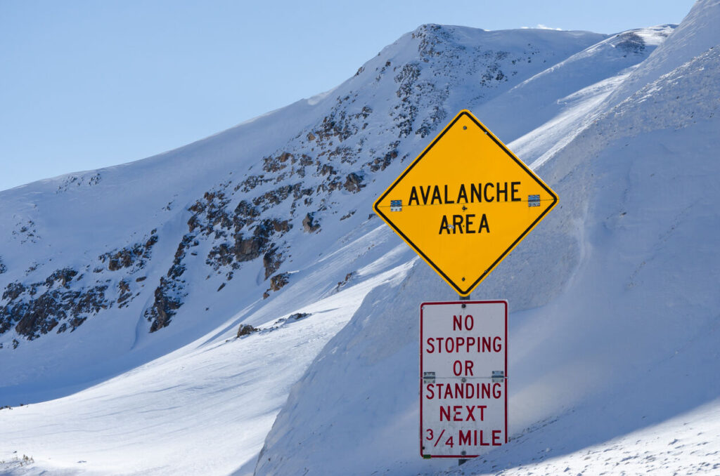
Colorado Avalanche Information Center warns of increased avalanche danger over holiday weekend
Piper Russell
piper.russell@outtherecolorado.com
Updated 7 hours ago
With the new snow that has fallen over Colorado, the Colorado Avalanche Information Center (CAIC) is warning those heading into the backcountry of heightened avalanche risk. According to the CAIC, parts of the northern and central mountains got more than...
Piper Russell
Reporter

Air Force women complete season sweep of San Jose State with difficult road trip looming
Brent Briggeman
brent-briggeman@denvergazette.com
Updated 3 hours ago
As teams begin sorting themselves late in the Mountain West season, the Air Force women can confidently say they reside north of the conference cellar. How much higher? Stay tuned. The Falcons shrugged aside a threat from San Jose State...
Brent Briggeman
Reporter

Mark Kiszla: How best little hockey town in USA made it Brock Nelson’s destiny to play in Winter Olympics
Mark Kiszla mark.kiszla@denvergazette.com
mark.kiszla@denvergazette.com
Updated 4 hours ago
MILAN – The river is frozen hard as granite in the real Hockeytown, USA, where the wind chill out on Muskeg Bay is: Don’t ask. But inside the Nomad Tavern – where if the piping-hot pizza doesn’t warm the cockles of...