


Latest snow storm to deliver 3-6 inches in northern Colorado on Tuesday | Whiteout snow report
Snowpack loss of 22% across the state since month's beginning
Colorado’s skiing and snowboarding this weekend could be simply described as: ‘dust on crust on windward slopes, wind deposited soft powder on leeward slopes.’
More snow is forecast on Tuesday, then a prolonged period of calm, warm and dry heading into Christmas.
Recap:
The big news from Sunday was the wind around Colorado’s high country. Winds at Loveland blew between 20-25 mph most of the day, with gusts pushing in excess of 40 mph at times. A wind gust around 12:35 p.m., Sunday was recorded at 55.3 mph at Winter Park, according to WillyWeather.com.
Snow accumulations on Sunday morning were about as forecast from the ECMWF model. The NWS Blend of Models forecast higher totals and that didn’t happen.
The northern mountains received between 1-2 inches, the west central mountains between 1-2 inches and in the southern mountains a trace-1 inch.
Forecast:
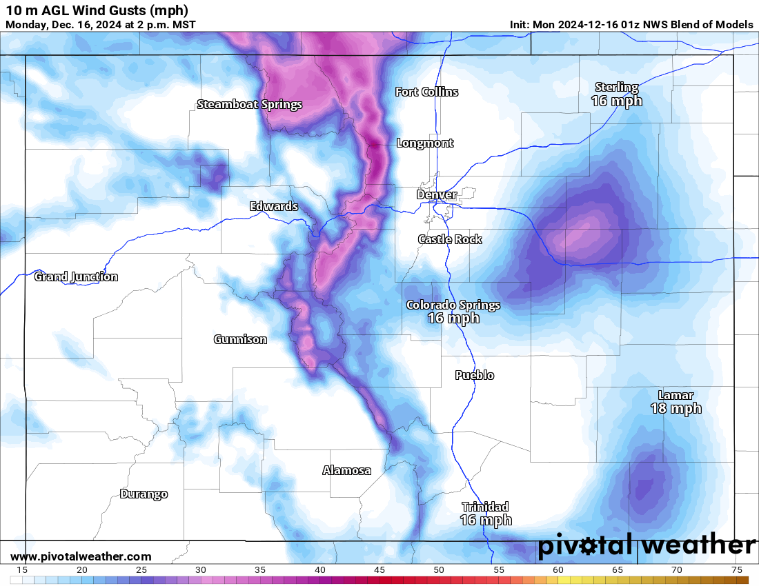
On Monday, the forecast calls for the sun coming back out in full, but windy conditions will persist. The northern Front Range, northern Sawatch Range and Park Range mountains are forecast to experience the highest winds and wind gusts, with sustained winds between 15-20 mph and gust between 35-45 mph.
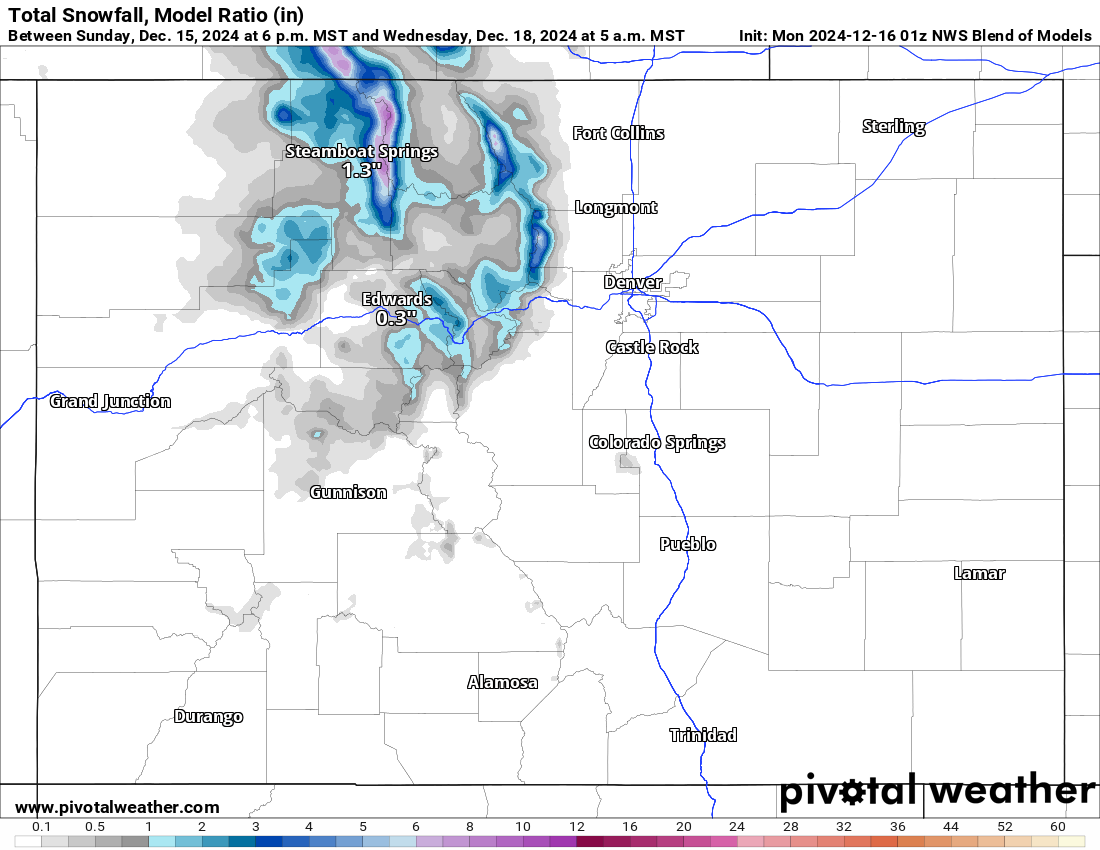
On Monday night, the last of the three ‘snow storms’ will begin pushing across northern Colorado through Tuesday, delivering between 3-6 inches of snow in the northern mountains sans around the Park Range, where up to 9 inches could potentially fall by Wednesday morning.
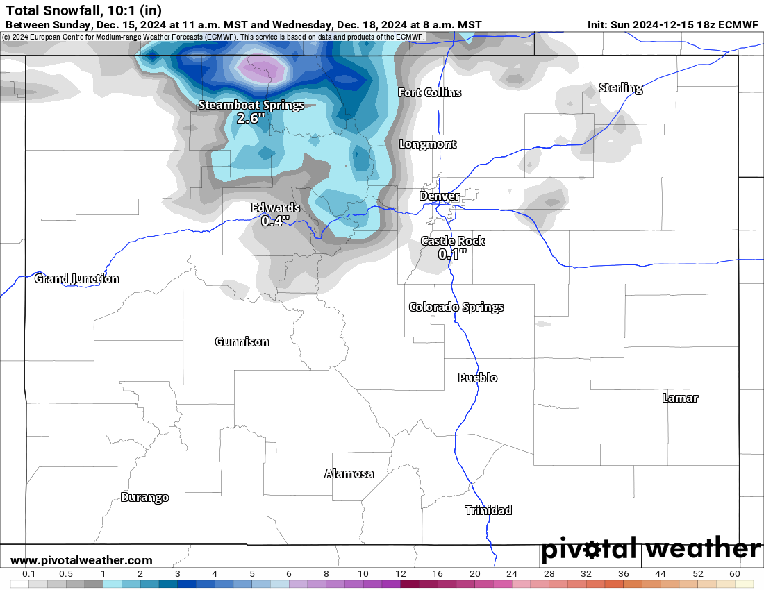
Steamboat and Howelsen are most likely the big winners with snowfall totals from this storm. Below are the NWS Blend of Models and ECMWF model for snowfall totals by first chair Wednesday.
The NWS Blend of Models model:
The ECMWF model:
From Thursday to next Monday, the forecast calls for dry, sunny and overall calm conditions each day, with highs in the high 20s at upper-elevation bases like Copper Mountain, Wolf Creek and Monarch and mid 30s at lower-elevation bases like Steamboat, Purgatory and Vail.
Snowpack:
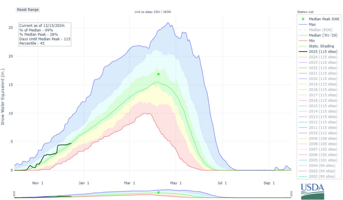
Colorado’s snowpack took a sizeable hit during the first 15 days of December. Colorado’s mean snowpack on Dec. 1 was 128% of average and at 4.5 inches of snow water equivalent. By Dec. 15, it had fallen to 99% of average, with 4.7 inches of snow water equivalent.
The last snows of this series are good news for the Yampa, White and Little Snake and Laramie and North Platte river basins in northwestern and northern Colorado respectively. Even with not a great forecasted total, the two river basins are lagging substantially far behind all other river basins within the state, meaning any snow is welcome.
Long range:
Beginning around Tuesday, Dec. 24, a stormy pattern is starting to shape up that could potentially bring better chances of snow from Christmas Eve to New Year’s Eve, with snow events on Christmas Eve and between Dec. 28-29.
More details will emerge with as late-December nears, but heading into 2025, Colorado’s high country could be gaining much needed snow for skiers and riders after a rather quiet December.
Today’s 24-hour snow totals from Colorado resorts:
Arapahoe Basin – 0″
Aspen Highlands – 0″
Aspen Mountain – 0″
Beaver Creek – 0″
Breckenridge – 0″
Buttermilk – 0″
Cooper – 0″
Copper Mountain – 0″
Crested Butte – 0″
Echo Mountain – Open for tubing
Eldora Mountain – 0″
Granby Ranch – 0″
Hesperus – Closed for the season
Howelsen Hill – 0″
Kendall Mountain – Opens Dec. 20
Keystone – 0″
Loveland – 0″
Monarch – 0″
Powderhorn – 0″
Purgatory – 0″
Silverton – Opens Dec. 28
Snowmass – 0″
Steamboat – 0″
Sunlight – 0″
Telluride – 0″
Vail – 0″
Winter Park – 0″
Wolf Creek – 0″