


White Christmas for Colorado’s high country probable with 2 storms forecast by year’s end | Whiteout snow report
Colorado’s snow forecast for Tuesday’s storm in the high country was a case of “under-forecasting leading to overproduction,” especially in the Front Range mountains.
Eldora Mountain in west Boulder County picked up 8-9 inches of new snow. The mountains around Steamboat in the Park Rage were forecast to potentially pick up 9-11 inches, but only about half of that was recorded at mid-mountain.
As the holiday nears, the chance for fresh snow on Christmas and in the days leading up to New Year’s Day, is elevating.
Recap:
Snow moved into northwestern Colorado about as forecast late Monday night. By Tuesday sunrise, snow was falling from Steamboat to Eldora and mostly north of Interstate 70.
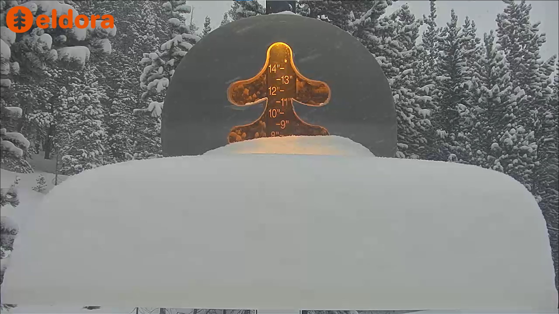
A nice surprise awaited ski patrollers at Eldora around brush off time at the resort’s snow stake. The resort had about 7 inches recorded shortly before 4 p.m., and another 2-3 inches added onto the platform into the evening and overnight.
Forecast:
From Wednesday to Monday, the state is forecast to enter another prolonged dry period. Unfortunately, temperatures are going to warm as well.
The National Weather Service in Boulder forecasts high temperatures to be in the high 30s to low 40s each day at Copper Mountain, then drop into the teens each night, potentially creating a melt and thaw cycle, creating impacted snow conditions like sun crusts. Forecasts from the NWS office in Grand Junction have similar conditions occurring in Aspen and Telluride during the same time frame.
The main driving factor of these persistent and prolonged dry spells continues to be a ridge of high pressure built in over the Four Corners and Great Basin areas.

In the ECMWF forecast model loop above (darker colors are air currents or vortices), it shows potential storms for Colorado getting pushed northward over the ridge and swept into the upper Midwest and Great Lakes states, leaving Colorado high and dry.
Until either a storm system can slide under the high pressure ridge or the high pressure ridge shifts position in the atmosphere, storms will continue to miss Colorado.
Long range:
Good news, however, is that around Monday, Dec. 23, the high pressure ridge will shift westward from the Four Corners region and low pressure storm waves can flow across the western US, including Colorado.
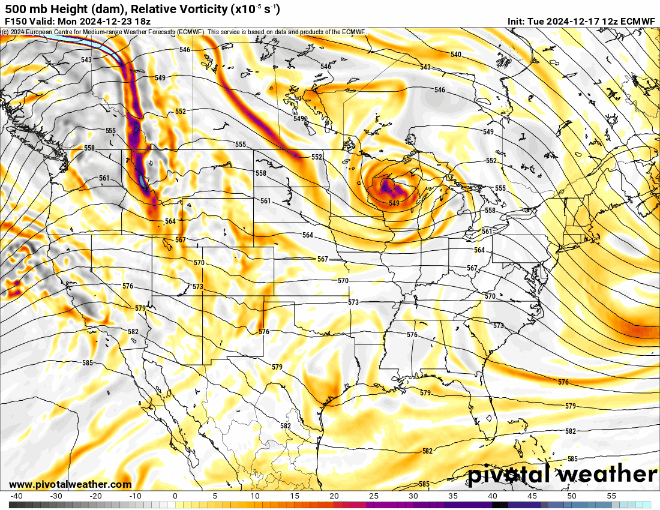
The above ECMWF forecast model from Monday, Dec. 23 to Wednesday, Jan. 1 shows the potential of storms to cross over or pass nearer Colorado, creating snow events.
It could be a white Christmas in Colorado after all as several forecast models, including the ECMWF, have snow falling across the state on Wednesday, Dec. 25. A white Christmas is defined as either officially one inch of snow already on the ground at 7 a.m., Christmas Day local time or it is snowing from Christmas Eve through Christmas Day.
This storm is forecast to bring respectable snow accumulations to most of the state, with the northwestern and northern mountains receiving the highest totals; potentially 4-7 inches.
Another storm a few days later — Saturday, Dec. 28 through Monday, Dec. 30 — could potentially replicate the Christmas Day storm, with snow totals within the same range.
As the dates of the two storms near and more model runs compute, better details about duration, snow totals and impacts will come to light.
Today’s 24-hour snow totals from Colorado resorts:
Arapahoe Basin – 3″
Aspen Highlands – 0″
Aspen Mountain – 1″
Beaver Creek – 1″
Breckenridge – 0″
Buttermilk – 0″
Cooper – 2″
Copper Mountain – 3″
Crested Butte – 0″
Echo Mountain – Open for tubing
Eldora Mountain – 6″
Granby Ranch – 2″
Hesperus – Closed for the season
Howelsen Hill – 0″
Kendall Mountain – Opens Dec. 20
Keystone – 2″
Loveland – 5″
Monarch – 0″
Powderhorn – 0″
Purgatory – 0″
Silverton – Opens Dec. 28
Snowmass – 1″
Steamboat – 4″
Sunlight – 0″
Telluride – 0″
Vail – 2″
Winter Park – 7″
Wolf Creek – 0″