


Sub-zero temperatures and more snow forecast for Colorado’s mountains | Whiteout snow report
Upslope storm to bring snow to metro Denver, Colorado Springs too
A series of sub-zero overnight lows, along with light to moderate snowfall totals, are forecast throughout Colorado’s high country during the first full week of January.
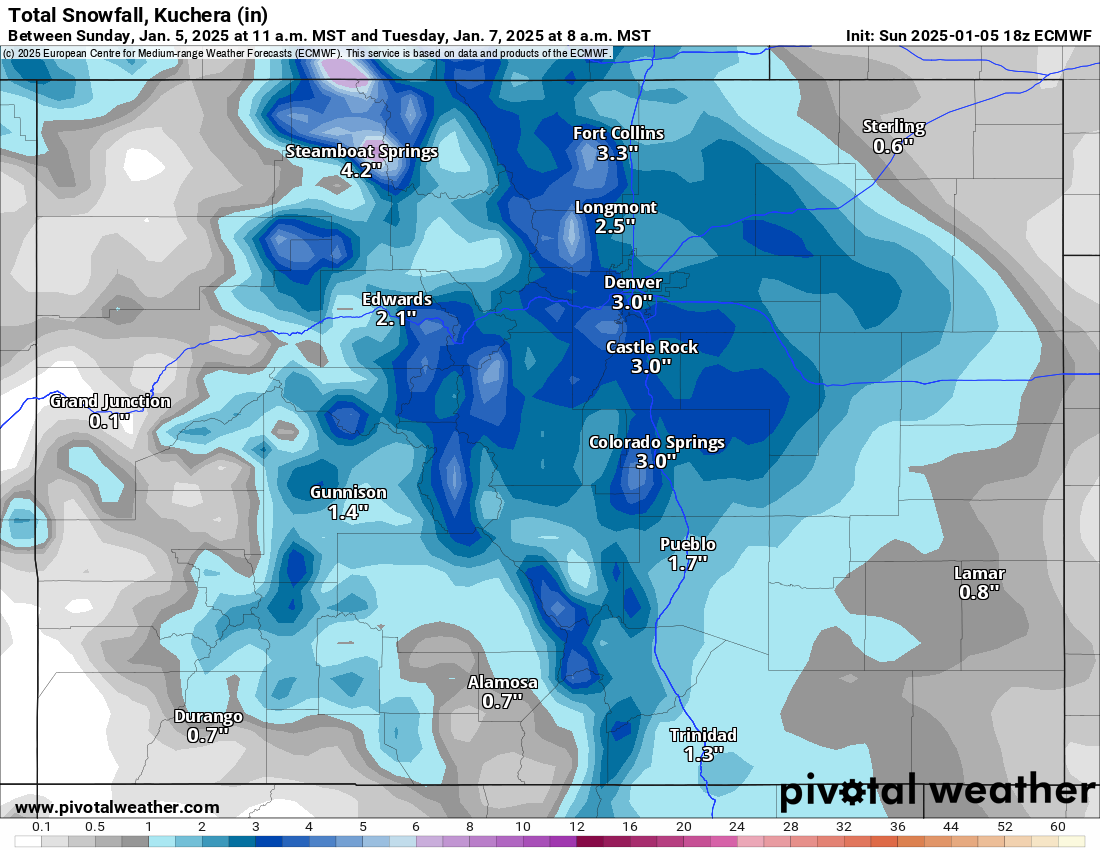
Snow will fall across Colorado’s Front Range foothills and urban corridor from Fort Collins to Trinidad throughout the week’s snow event, bringing 4-8 inches with it by week’s end.
Skiers and riders have had good luck in 2025 so far as snowpack is back near 100% again.
Recap:
Sunday’s snowfall totals were about as forecast, with a few ski areas in the west central and northern San Juan mountains receiving more snow than forecast.
Snow showers ended across most of the state around sunset, with additional snow accumulations in the northern mountains of between 2-4 inches, in the central mountains between 1-3 inches and in the southern mountains between 0-1.5 inches.
Forecast:
On Monday, snow returns to the northern and central mountains on northwest flow as left over moisture from winter storm Blair is pulled eastward. Snow will fall lightly all day and into Tuesday overnight.
Snow accumulations for first chairs Tuesday for the northern mountains range between 3-6 inches, in the central mountains 2-4 inches and in the southern mountains between a 1-2 inches.
Snowfall amounts in the upper peaks of the Park Range could be higher like they were with Saturday’s snow event. Steamboat’s mid-mountain station reported 7 inches new, but up at the summit, over double was reported, with 15 inches laid down.
On Tuesday morning, the winds shift from northwest flowing to northeast flowing, allowing for upsloping snows to fall from Wyoming to New Mexico along Colorado’s Front Range foothills and east of the Continental Divide.
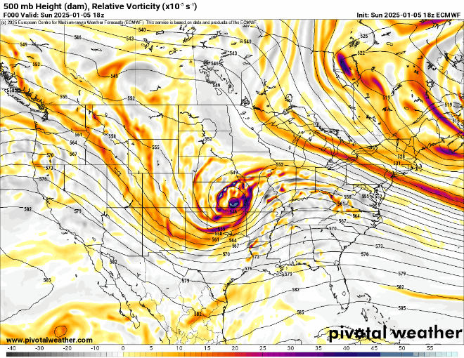
A southward dipping area of low pressure over Las Vegas, Nevada will dip far south in Baja, Mexico before pushing eastward across northern Mexico throughout the week.
Ski areas like Echo and Eldora Mountain could receive between 2-4 inches from the upslope event, while the Sawatch Mountains around Monarch could see up to 8 inches by Wednesday’s first chairs.
The southern mountains will finally get some much needed snow from this southerly flowing snow storm. Wolf Creek hasn’t received any accumulations since Dec. 28 and received only 13 inches of snow total for the month.
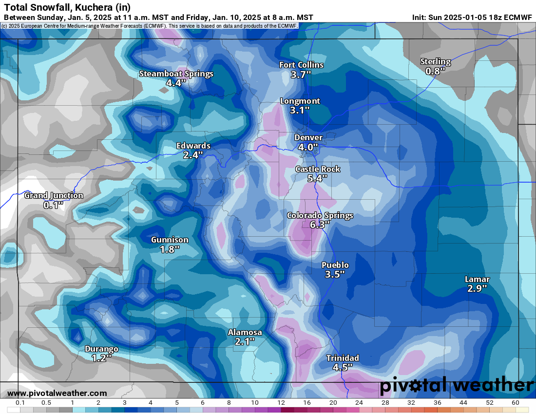
Snowfall totals by week’s end in the northern mountains are between 6-10 inches, in the central mountains between 5-9 inches and in the southern mountains between 3-7 inches.
The other story for the first full week of January 2025 will be the temperatures.
The National Weather Service offices in Boulder and Grand Junction have high temperatures topping out in the upper teens and low 20s each day all week.
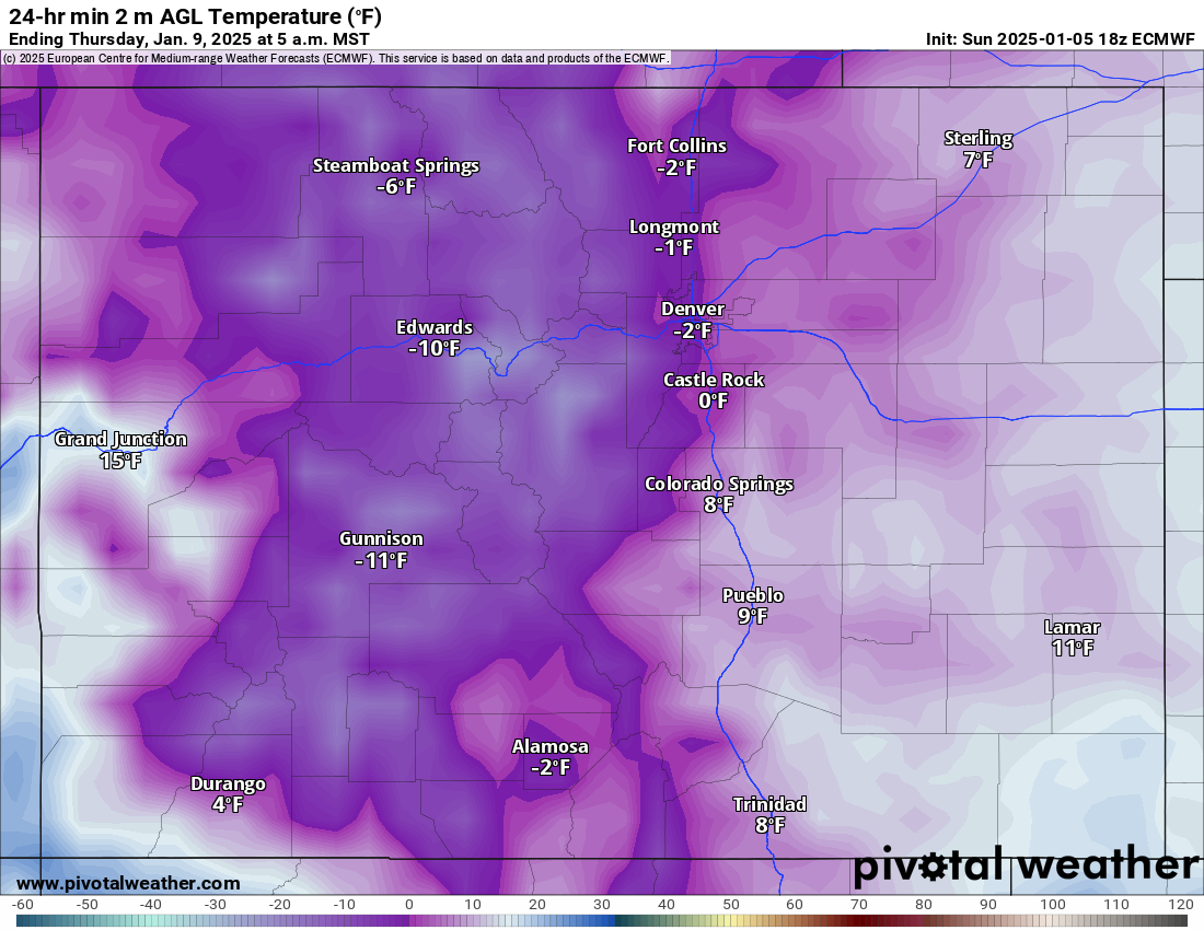
But overnight lows all week, especially Wednesday, Thursday and Friday, will be between 0 and -5 at most base areas and between -5 and -15 at mid mountains and summits.
The ECMWF forecast model shows some mountainous areas around Vail Pass and Loveland Pass reaching -15 to -25 degrees below 0 Thursday morning.
Colorado’s snowpack:
The state’s snowpack as of Jan. 5 is at 98% of average after continuous snows helped rebuild the dwindled totals from December’s lack of snowfall.

Long range:
From Thursday through next Thursday, Jan. 16, Colorado looks to be on the southern edge of multiple storms tracking across the northern Rockies. This coming weekend is offering the best chances for moderate snowfall as low pressure systems skirt the northern mountains and northeastern Plains on a northwest flow.
More detailed snowfall totals will come into view over the next 48 hours, but early forecasts call for snow accumulations in the northern mountains of between 4-8 inches, in the central mountains between 2-4 inches and in the southern mountains between 1-4 inches.
Today’s 24-hour snow totals from Colorado resorts:
Arapahoe Basin – 2″
Aspen Highlands – 2″
Aspen Mountain – 2″
Beaver Creek – 3″
Breckenridge – 2″
Buttermilk – 1″
Cooper – 1″
Copper Mountain – 3″
Crested Butte – 0″
Echo Mountain – 0″, plus tubing
Eldora Mountain – 3″
Granby Ranch – 1″
Hesperus – Closed for the season
Howelsen Hill – 4″
Kendall Mountain – 0″
Keystone – 1″
Loveland – 3″
Monarch – 7″
Powderhorn – 0″
Purgatory – 0″
Silverton – 0″
Snowmass – 2″
Steamboat – 5″
Sunlight – 0″
Telluride – 0″
Vail – 6″
Winter Park – 2″
Wolf Creek – 0″