


Polar vortex to blast 12-24 inches of snow across Colorado’s mountains over MLK weekend
Sub-zero temperatures will make skiing and riding potentially dangerous | Whiteout snow report
The Arctic air mass will be in Colorado Friday afternoon, but the effects of the polar vortex won’t be fully felt until after the sun goes down.
Snow will come into the state’s high country in two waves, providing a fresh blanket of snow over the MLK Day weekend and 12-24 inches is still forecast by Tuesday.
Recap:
Wednesday and Thursday offered dry and sunny conditions, with no new snow reported across the state.
The National Weather Service in Boulder recorded a high temperature of 34 degrees on Thursday at Copper Mountain, a measurable step up from Wednesday’s high of only 10 degrees.
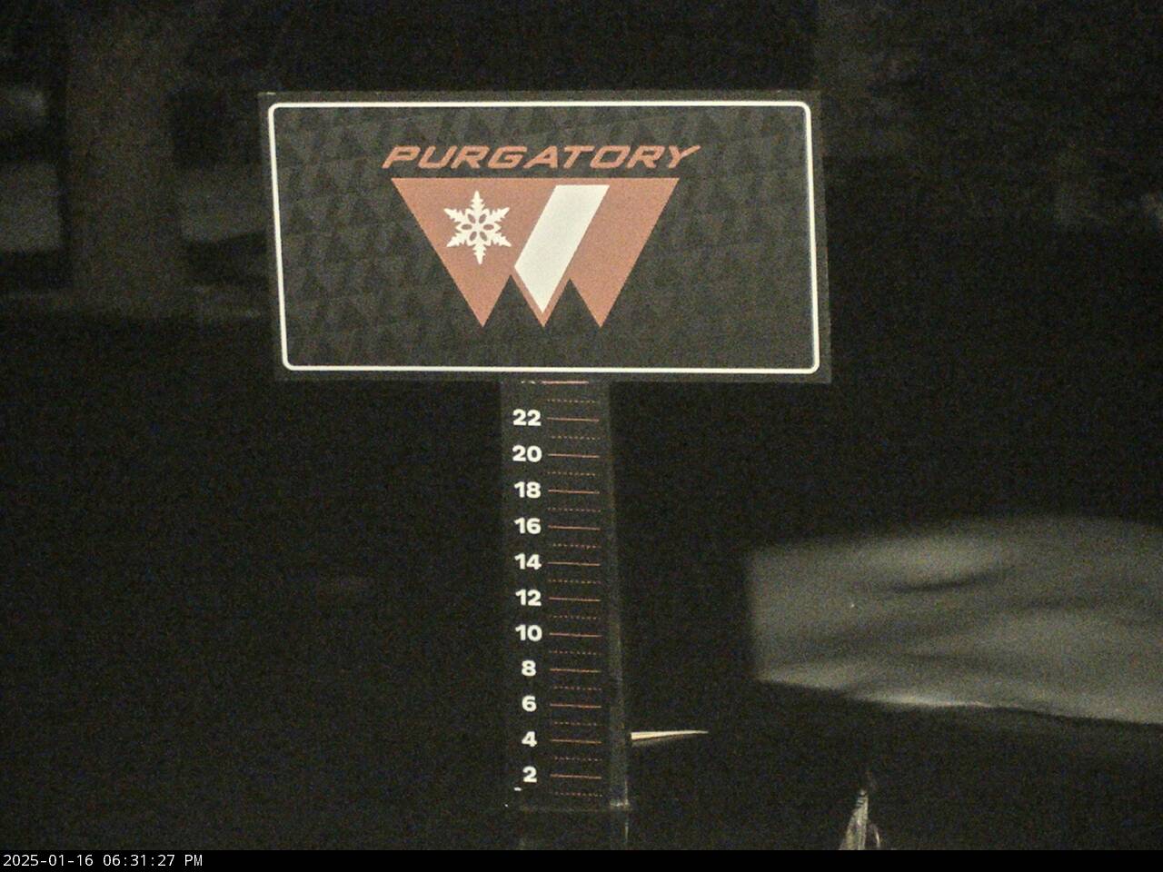
Purgatory Mountain Resort in southwestern Colorado is still struggling to receive notable snow accumulations. The resort does boast a 32-inch snow base but has only received 69 inches for the season so far. The resort has only received 5 inches of snow in January and none since Wednesday, Jan. 8.
Forecast:
The cold front comes in just ahead of the snow on Friday afternoon, and the northern mountains will taste the first flakes throughout the evening and into Saturday.
Forecast models have a band of heavy snow pushing into the state on a northwest flow, with an area of low pressure over eastern Oklahoma and north Texas helping to drive moisture back into Colorado.

This feature should produce some upsloping winds, beneficial for snow showers at resorts east of and on the Continental Divide, and should enhance snowfall totals for the Front Range mountains and foothills.
Arctic cold:
Colorado’s ski areas, resorts, and mountain communities are going to be very cold for four to five days as the Arctic freeze pushes in on Friday afternoon.
Skiing and riding on Saturday, Sunday, and Monday will be the coldest, with nearly every ski area experiencing high temperatures only in the single digits or below zero.
Ski areas and resorts higher in elevation and closer to the Front Range mountains will be the coldest all three days.
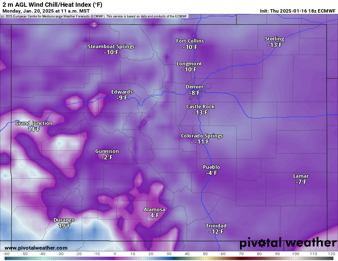
Wind chills will make skiing and riding even colder, with forecasted wind chills of between -5 to -35 degrees depending on where you are. Telluride and Purgatory, -5 degree wind chill. Loveland and Arapahoe Basin, -30 degree wind chill.
Snow:
This first wave of snow forecasts snow accumulations in the northern mountains between 4-10 inches west of the divide and between 8-16 inches east of the divide, with the potential of up to 22 inches in Boulder County, yet might not hit Eldora fully if the storm energy stays lower in elevation and further east like some of the models forecast.
In the central mountains, snow accumulations of between 4-8 inches (a notch up from Wednesday’s model runs) and in the southwestern mountains between 2-6 inches (a notch up) and in the southeastern mountains between 8-14 inches (more focused in the Wet Mountains).
Plan on a cold powder day on Saturday north of I-70 and a cold light powder day south of I-70.
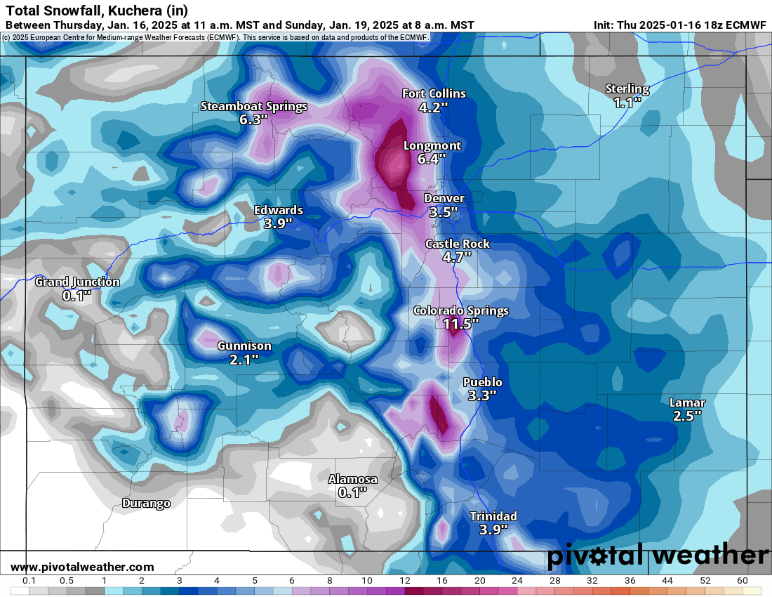
The second wave is tracking right behind the first wave and brings snow from early Sunday to Monday night.
Additional snow accumulations for the northern mountains west of the divide are between 3-5 inches and east of the divide between 4-8 inches, in the central mountains between 3-5 inches, and in the southwestern mountains between 2-3 inches, in the southern mountains near Wolf Creek between 5-8 inches, and in the southeastern mountains between 4-8 inches.
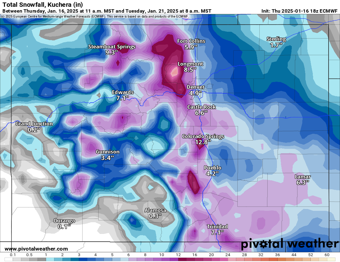
As reported earlier in the week, snowfall totals from the MLK Day storm waves for the northern mountains range between 5-24 inches, in the central mountains between 2-8 inches, and in the southern mountains between 3-24 inches.
The Front Range mountains along the Continental Divide and east of the divide should see the highest totals for skiers and riders throughout the weekend.
Long range:
Storm energy from the main west-to-east flow brushes Colorado’s northern mountains on Thursday, forecasted to bring a few inches north of I-70 and cold temperatures similar to the MLK Day event, but not as cold and not as long.
Thursday will be cold after a ‘warm’ Wednesday (8 degrees forecast for Wednesday at A-Basin compared to 5 degrees on Thursday). Then slight warming and dry conditions on Friday and Saturday.
More potential snow on yet another storm system brushing northern Colorado starts Sunday, Jan. 26 overnight, with the potential for more snow throughout the last week of January.
Today’s 24-hour snow totals from Colorado resorts:
Arapahoe Basin – 0″
Aspen Highlands – 0″
Aspen Mountain – 0″
Beaver Creek – 0″
Breckenridge – 0″
Buttermilk – 0″
Cooper – 0″
Copper Mountain – 0″
Crested Butte – 0″
Echo Mountain – 0″, plus tubing
Eldora Mountain – 0″
Granby Ranch – 0″
Hesperus – Closed for the season
Howelsen Hill – 0″
Kendall Mountain – 0″
Keystone – 0″
Loveland – 0″
Monarch – 0″
Powderhorn – 0″
Purgatory – 0″
Silverton – 0″
Snowmass – 0″
Steamboat – 0″
Sunlight – 0″
Telluride – 0″
Vail – 0″
Winter Park – 0″
Wolf Creek – 0″