


3-5 feet of snow forecast in Colorado’s high country by Presidents’ Day weekend

The snow machine pumping frosty flakes into Colorado’s high country continues into the second full week of February, with multiple feet forecast by Presidents’ Day weekend.
Arctic cold will make its way south into the state as well, with the coldest temperatures of the month coming with, but will not be as cold as January’s Arctic blast where low temperatures dipped to -40 degrees in places.
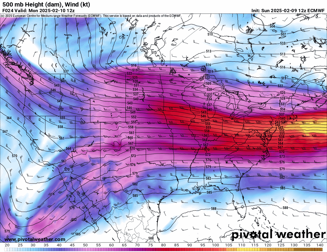
An ECMWF 500 mb Height (dam), Wind (kt) forecast loop of the U.S. from February 10-18, 2025. West-to-east zonal flow will dominate weather across Colorado over the next 8-10 days as storms bring regular snows to the state.
PivotalWeather.com


An ECMWF 500 mb Height (dam), Wind (kt) forecast loop of the U.S. from February 10-18, 2025. West-to-east zonal flow will dominate weather across Colorado over the next 8-10 days as storms bring regular snows to the state.
An active period continues past Presidents’ Day weekend as well, with more snow forecast during the third week of the month as continued moisture is funneled into the state on an overall west-to-east zonal flow.
Recap:
Saturday and Sunday were powder days, an event not seen around Colorado’s ski areas and resorts much in the last few weeks; the last good snows were around MLK Jr. Day.
Top winners of the most snow from the weekend were Winter Park (18″) in the northern mountains, Aspen/Snowmass (11″) in the central mountains and unfortunately no southern mountains areas received any snow, so Powderhorn (3″) takes the prize by proxy.
Forecast:
Snow showers develop in the southern mountains early Monday morning via a band of moisture being pulled across the state from the weekend storm’s west-to-east zonal flow.
Accumulations by Tuesday morning’s first chairs down south are forecast to be between 2-4 inches.
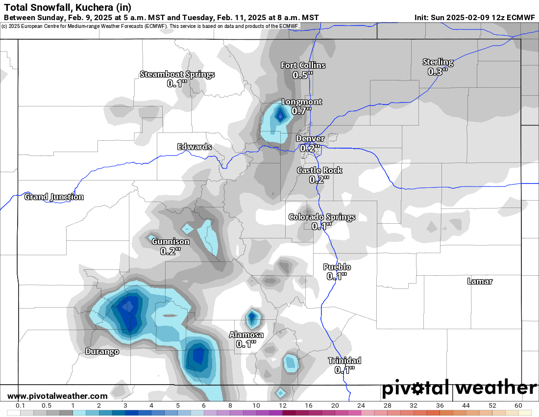
An ECMWF Total snowfall, Kuchera (in) forecast loop of Colorado from 5 a.m., Sunday, Feb. 9 to 8 a.m., Tuesday, Feb. 11, 2025.
PivotalWeather.com


An ECMWF Total snowfall, Kuchera (in) forecast loop of Colorado from 5 a.m., Sunday, Feb. 9 to 8 a.m., Tuesday, Feb. 11, 2025.
Meanwhile, overnight Tuesday, snow showers begin in the central mountains and northeastern mountains west of Boulder and Denver.
More wide spread snow showers begin across all three mountain zones by Tuesday afternoon and ramp up in intensity Tuesday night through Wednesday late morning.
An ECMWF Total snowfall, Kuchera (in) forecast loop of Colorado from 8 p.m., Sunday, Feb. 9 to 11 a.m., Thursday, Feb. 13, 2025.
PivotalWeather.com


An ECMWF Total snowfall, Kuchera (in) forecast loop of Colorado from 8 p.m., Sunday, Feb. 9 to 11 a.m., Thursday, Feb. 13, 2025.
Snowfall totals for Wednesday’s first chairs are between 8-10 inches in the northern and central mountains, and 10-20 inches in the southern mountains, with the highest totals in the eastern San Juan Mountains near Wolf Creek.
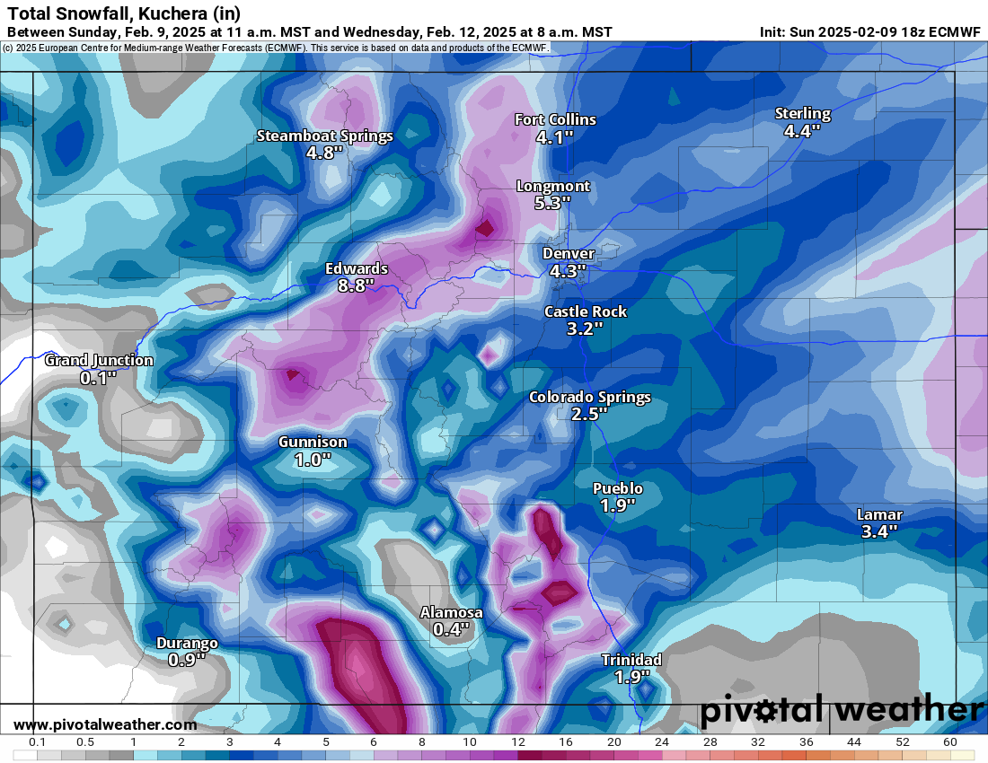
An ECMWF Total snowfall, Kuchera (in) forecast loop of Colorado from 11 a.m., Sunday, Feb. 9 to 8 a.m., Wednesday, Feb. 12, 2025.
PivotalWeather.com


An ECMWF Total snowfall, Kuchera (in) forecast loop of Colorado from 11 a.m., Sunday, Feb. 9 to 8 a.m., Wednesday, Feb. 12, 2025.
Snow will continue to fall Wednesday through Thursday morning, adding an additional 2-4 inches across the state.
Arctic air is still forecast to accompany the snows in the early part of the week, creating frigid conditions both on Tuesday and Wednesday, with highs only in the teens on Tuesday and single digits on Wednesday. However, further west ski areas like Crested Butte, Telluride and Powderhorn will be warmer on both days with highs in the upper 20s on Tuesday and mid to high teens on Wednesday.
Thursday is forecast to start off partly cloudy then transition into snow showers developing through the afternoon and night.
Long-term forecast:
Snow continues on Valentine’s Day Friday, and Saturday of President’s Day weekend, with additional snow accumulations happening across all three mountain zones.
Sunday’s first chairs could be soft and light. Sunday night’s forecast is trending toward snow showers picking up again and lasting into Tuesday, Feb. 18.
The potential for 3-5 feet of snow in favored areas in the central and southern mountains, and 2-3 feet in the northern mountains, is possible by Feb. 18.
The potential for the whole week to have some snow falling regularly is appearing on most forecast models as well.
Today’s 24-hour snow totals from Colorado resorts:
Arapahoe Basin – 0″
Aspen Highlands – 0″
Aspen Mountain – 0″
Beaver Creek – 0″
Breckenridge – 0″
Buttermilk – 0″
Cooper – 0″
Copper Mountain – 0″
Crested Butte – 0″
Echo Mountain – 0″, plus tubing
Eldora Mountain – 0″
Granby Ranch – 0″
Hesperus – Closed for the season
Howelsen Hill – 0″
Kendall Mountain – 0″
Keystone – 0″
Loveland – 0″
Monarch – 0″
Powderhorn – 0″
Purgatory – 0″
Silverton – 0″
Snowmass – 0″
Steamboat – 0″
Sunlight – 0″
Telluride – 0″
Vail – 0″
Winter Park – 0″
Wolf Creek – 0″
(Contact Denver Gazette digital producer Jonathan Ingraham at [email protected] or on X at @Skingraham and Instagram at @Skingraham311.)