


30-40″ of snow forecast for Colorado by mid month from four-storm punch as March starts
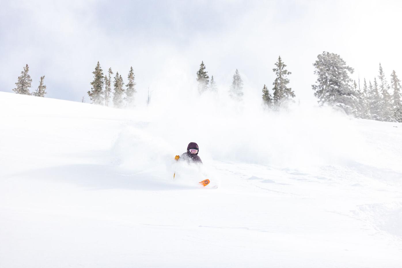
Courtesy, Taylor Ahearn/Crested Butte Mountain Resort
February will end on a sunny and calm note in Colorado’s high country at the state’s ski areas and resorts, with slightly below to moderately below average snowfall totals season-to-date (see below for totals).
March starts snowy as four projected storms are forecast to pass through the state over the first 14 days, with the potential for a fifth storm starting around March 15.
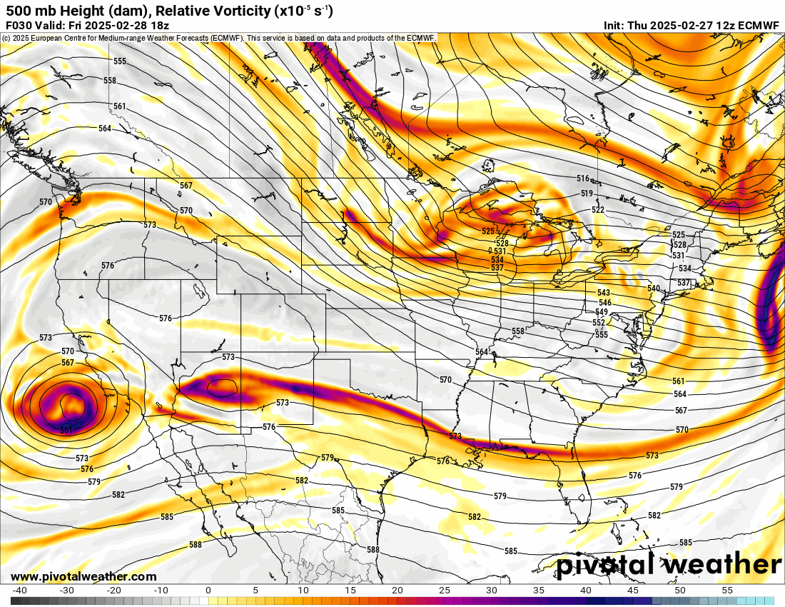
An ECMWF 500 mb Height (dam), Relative Vorticity forecast loop of the U.S. from 5 a.m., Thursday, Feb. 27 - 5 a.m., Friday, March 14, 2025. Four storm waves pass through Colorado during the first 14 days of March, bringing potentially feet of snow to the state.
PivotalWeather.com


An ECMWF 500 mb Height (dam), Relative Vorticity forecast loop of the U.S. from 5 a.m., Thursday, Feb. 27 – 5 a.m., Friday, March 14, 2025. Four storm waves pass through Colorado during the first 14 days of March, bringing potentially feet of snow to the state.
These four storms have the potential to deliver feet of snow by mid-month as March roars in with stormy conditions.
Recap:
Wednesday was cool, and Thursday was warmer, but neither day provided any new snow to the slopes.
The National Weather Service in Boulder recorded a high temperature of 37 degrees at the summit of Copper Mountain, and the NWS office in Grand Junction recorded a high temperature of 34 degrees at the summit of Telluride Resort.
Colorado’s snowpack:
Colorado’s snowpack shrank 5 percentage points over the last seven days of February. The state finished the month at 88% of the median average and 11.1 inches of snow water equivalent, 1.5 inches below the median average-to-date of 12.6 inches.
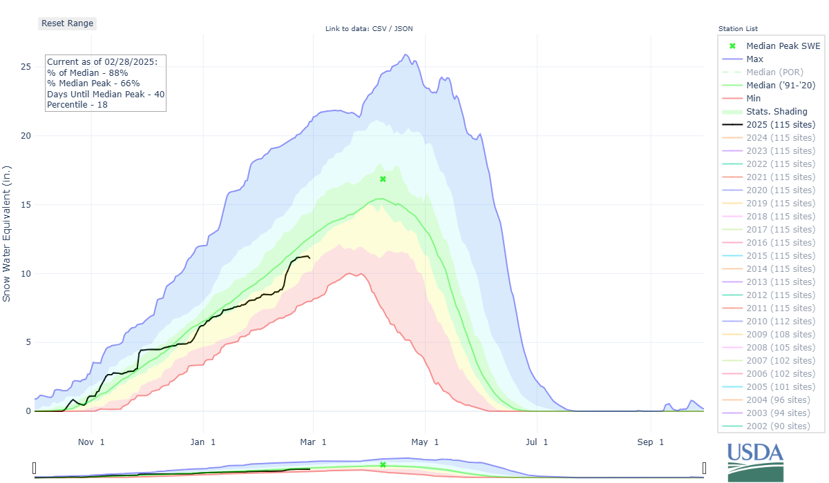
Colorado's median snowpack is at 88% of average on Feb. 28, 2025.
Natural Resources Conservation Service


Colorado’s median snowpack is at 88% of average on Feb. 28, 2025.
Forecast:
Friday and Saturday continue the sunny and calm trend across all three mountain zones, with no snow and high temperatures in the lower 40s at most base areas and mid to upper-30s on the mountain and at the summits.
Storm 1 – Starting Sunday morning, the first wave of storm energy enters Colorado in the southern mountains, delivering light accumulations of between trace-2 inches, with more than likely all storm energy focused on the San Juan Mountains. Sunday will be cooler than Friday and Saturday, with clouds and maybe a pocket shower in the central and northern mountains. Otherwise, cloudy conditions should prevail.
This storm is not very organized, lacks moisture, and generally falls apart when it makes landfall in southern California on Saturday.
Storm 2 – Starting Monday morning and continuing through Wednesday morning, a larger low-pressure system, following Storm 1’s path across northern Arizona and New Mexico, begins delivering snow to Colorado for about 48 hours.
This storm, with increased moisture content and better organization, should bring much better snowfall. Forecasted accumulations of between 5-9 inches in the southern mountains are possible, between 3-6 inches in the central mountains, and between 3-11 inches in the northern mountains (east of the Continental Divide with the highest totals).
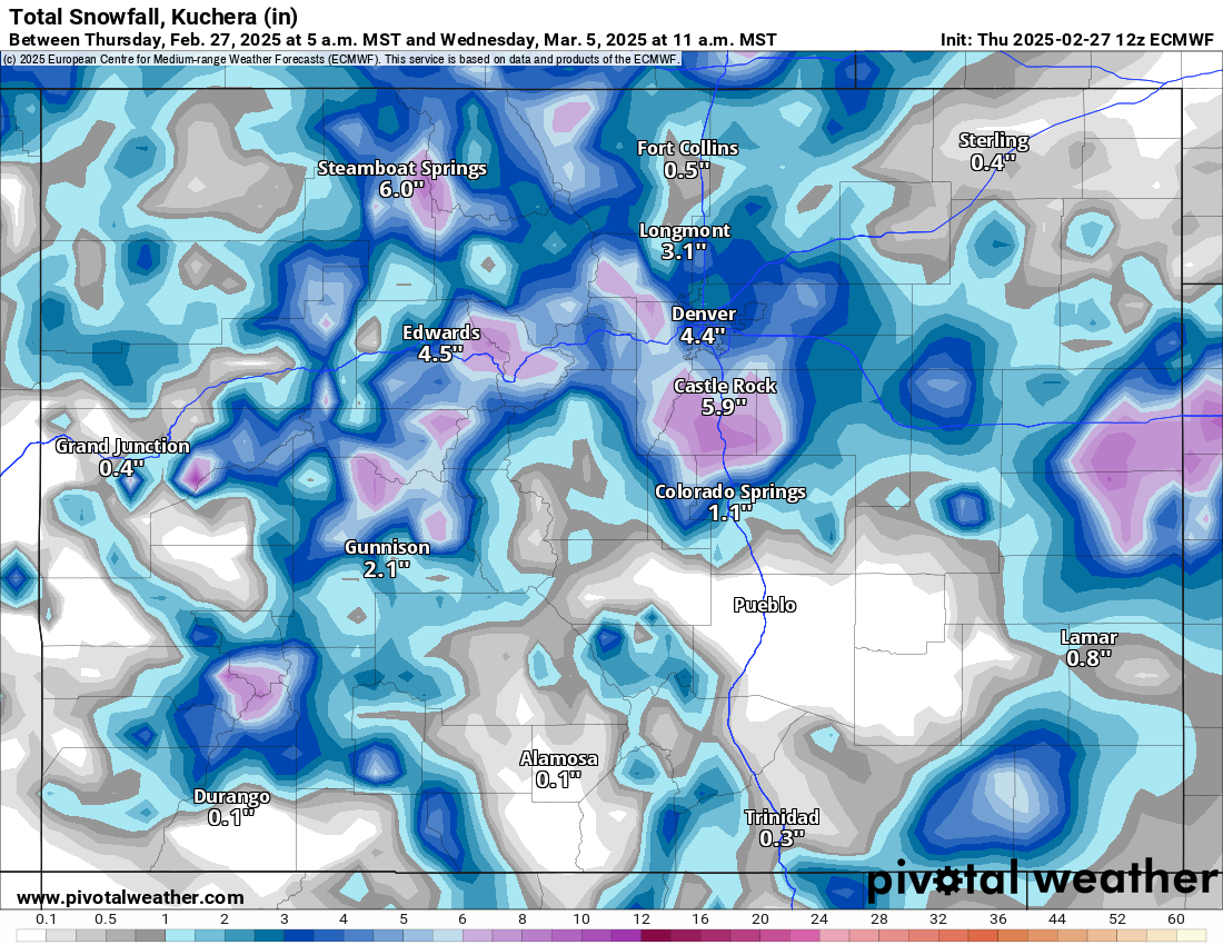
An ECMWF Total snowfall, Kuchera (in) forecast map of Colorado from 5 a.m., Thursday, Feb. 27 to 11 a.m., Wednesday, March 5, 2025.
PivotalWeather.com


An ECMWF Total snowfall, Kuchera (in) forecast map of Colorado from 5 a.m., Thursday, Feb. 27 to 11 a.m., Wednesday, March 5, 2025.
Storm 3 – From Wednesday night through Friday morning, another low-pressure system passes through southern Colorado, bringing slightly higher snowfall amounts to all three mountain zones.
The European model shows forecasted accumulations in the southern mountains of between 8-14 inches, in the central mountains between 4-7 inches, and between 3-6 inches in the northern mountains.
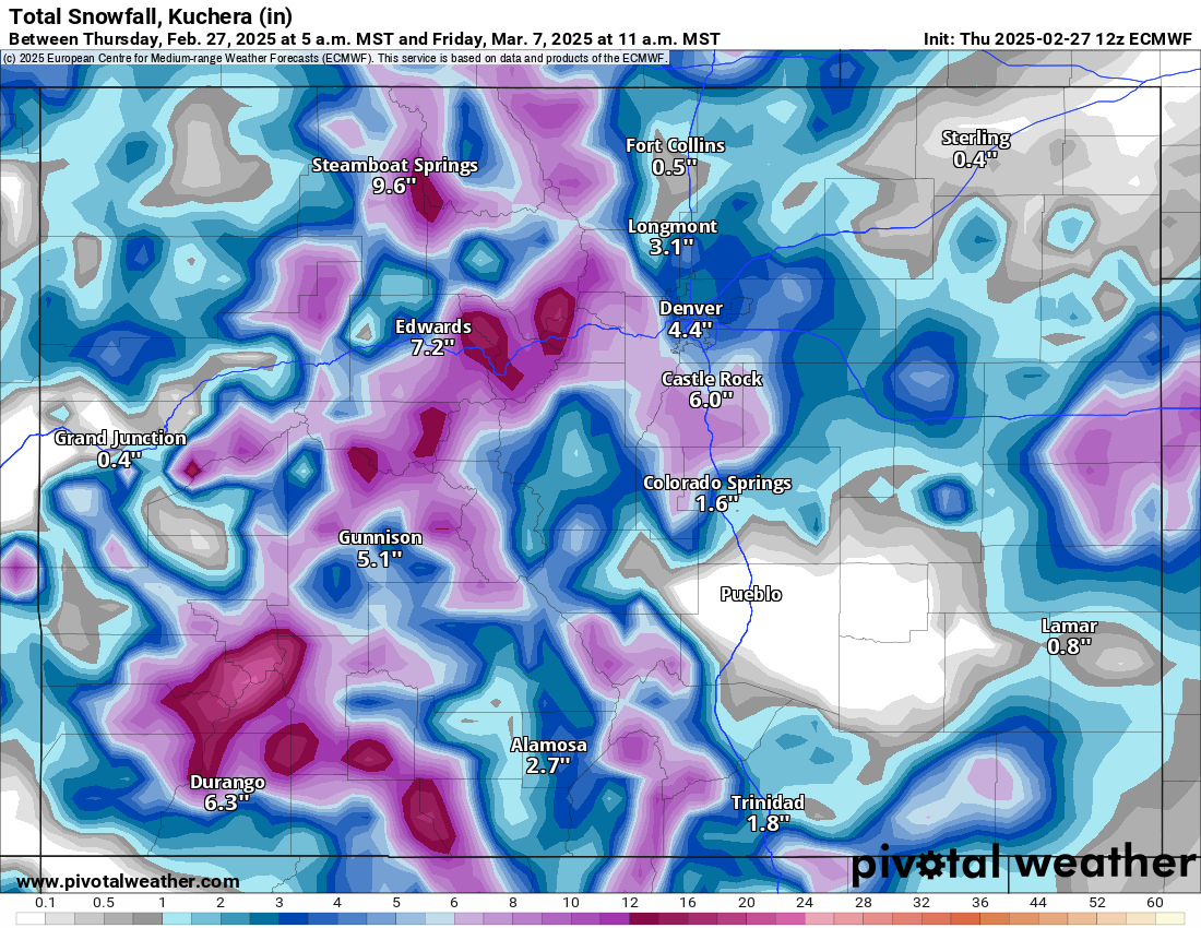
An ECMWF Total snowfall, Kuchera (in) forecast map of Colorado from 5 a.m., Thursday, Feb. 27 to 11 a.m., Friday, March 7, 2025.
PivotalWeather.com


An ECMWF Total snowfall, Kuchera (in) forecast map of Colorado from 5 a.m., Thursday, Feb. 27 to 11 a.m., Friday, March 7, 2025.
Saturday, March 8, Sunday, March 9, and Monday, March 10 are forecast to be dry and sunny.
Storm 4 – Starting Tuesday, March 11 early morning through late Wednesday, March 12 night, another area of low pressure dipping southeastward on northwest winds, is forecast to deliver more snow to all three zones.
The northern mountains see snow first, then the central and southern mountains. Wrap-around moisture provides some snow to the southeastern mountains west of Pueblo and Walsenburg.
This storm is pretty far out and more model runs will need to be rendered to get better snowfall totals dialed in before an accurate forecast can be made.
Long-term forecast:
Starting Thursday, March 13, more chances of snow are in the mix as continued storm energy moves into the state from the northwest. This storm system could last into Saturday, March 15.
Today’s 24-hour & (season-to-date) snow totals for Colorado ski resorts:
Arapahoe Basin – 0″ (189”)
Aspen Highlands – 0″ (208”)
Aspen Mountain – 0″ (179”)
Beaver Creek – 0″ (195”)
Breckenridge – 0″ (237”)
Buttermilk – 0″ (126”)
Cooper – 0″ (162”)
Copper Mountain – 0″ (256”)
Crested Butte – 0″ (172”)
Echo Mountain – 0″ (63”)
Eldora Mountain – 0″ (156”)
Granby Ranch – 0″ (93”)
Hesperus – Closed for the season
Howelsen Hill – 0″ (51”)
Kendall Mountain – 0″ (105”)
Keystone – 0″ (202”)
Loveland – 0″ (207”)
Monarch – 0″ (159”)
Powderhorn – 0″ (149”)
Purgatory – 0″ (111”)
Silverton – 0″ (225”)
Snowmass – 0 (200”)
Steamboat – 0″ (239”)
Sunlight – 0″ (101”)
Telluride – 0″ (156”)
Vail – 0″ (246”)
Winter Park – 0″ (259”)
Wolf Creek – 0″ (140”)
(Contact Denver Gazette digital producer Jonathan Ingraham at [email protected] or on X at @Skingraham and Instagram at @Skingraham311.)