


Another round of 12-plus inches of snow set to follow 30-plus fresh inches in Colorado

On the heels of a storm that dropped up to 36 inches of snow in some parts of the state over a 72-hour period, another round of big snow is headed for Colorado.
Over the last three days, double-digit snow totals landed on many of the state’s tallest peaks. According to mapping from the National Weather Service (NWS), peaks that got the deepest totals were those west of Montrose, as well as those in the area of the Grand Mesa – about 30 to 36 inches in places hit the hardest. After all that snow, the state’s snowpack level is at about 90 percent of the norm for March 16.
After a day or so of dryness, more wintery weather will be incoming, most likely to hit between Tuesday morning and Wednesday morning and once again expected to bring widespread snowfall to the state’s mountainous region.
In the most likely ‘expected’ snowfall scenario through Wednesday morning per a forecast provided by the NWS, totals reach into the 12 to 18-inch range, favoring Western Slope peaks. The peaks of the state’s central mountains get between four and 12 inches.
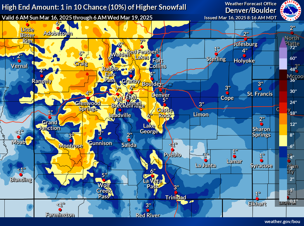
The ‘high-end’ forecast, however, is where the snowfall situation gets interesting. In this scenario, totals of up to 12 inches are much more widespread with snowfall likely to have greater impacts along the I-70 mountain corridor, as well.
See both scenarios depicted on the mapping below:
According to the OpenSnow report, Silverton and Telluride should get the most fresh powder over the next five days – 13″ and 12″, respectively. Find a full resort-by-resort breakdown here.
Those traveling during this period should prepare for winter conditions by packing these 22 survival items for their trip.
Find additional weather information on the National Weather Service website.
STAY INFORMED: Get free Colorado news with our daily newsletter (Click here)

Get OutThere
Signup today for free and be the first to get notified on new updates.
PREV
PREVIOUS

Should Broncos Country worry about Evan Engram's injury history? | The Starting Lineup
The Starting Lineup Turn on the game! Three must-see events this week: 1. Dallas Stars at Avalanche (1:30 p.m. Sunday, TNT/truTV) — Welcome back, Mikko Rantanen. His No. 96 sweater one day will hang in the rafters of Ball Arena — even though his initial return to Colorado could hear some boos. 2. Nuggets at […]

Denver's best pizza March Madness bracket: Top pizzerias advance to Sweet 16
This year’s Denver’s Best Pizza bracket is entirely reader-driven—after taking your reader nominations and tallying the pizza spots with the most votes, we narrowed the field down from hundreds of restaurants down to 32. After thousands of votes in the first round, the field for the Sweet 16 in the search for Denver’s best pizza […]