


8 to 18 inches of snow for Colorado still ‘good to go’ for Easter week
Mid-April storms to bring spring snow back to the Centennial State | Whiteout snow report
Snow showers starts off the week across northern Colorado’s high country, with between 1-4 inches new on Monday morning for the resorts still open and, of course, the backcountry.
Light snow falls mid-week ahead of large and prolonged storm event heading into the Easter weekend. Snowfall potential from this storm could push upwards of 12 inches in some spots, with the possibility of up to 18 inches by Monday morning.
The forecast calls for more storminess early next as another round of snow showers are possible heading into late April.
Recap:
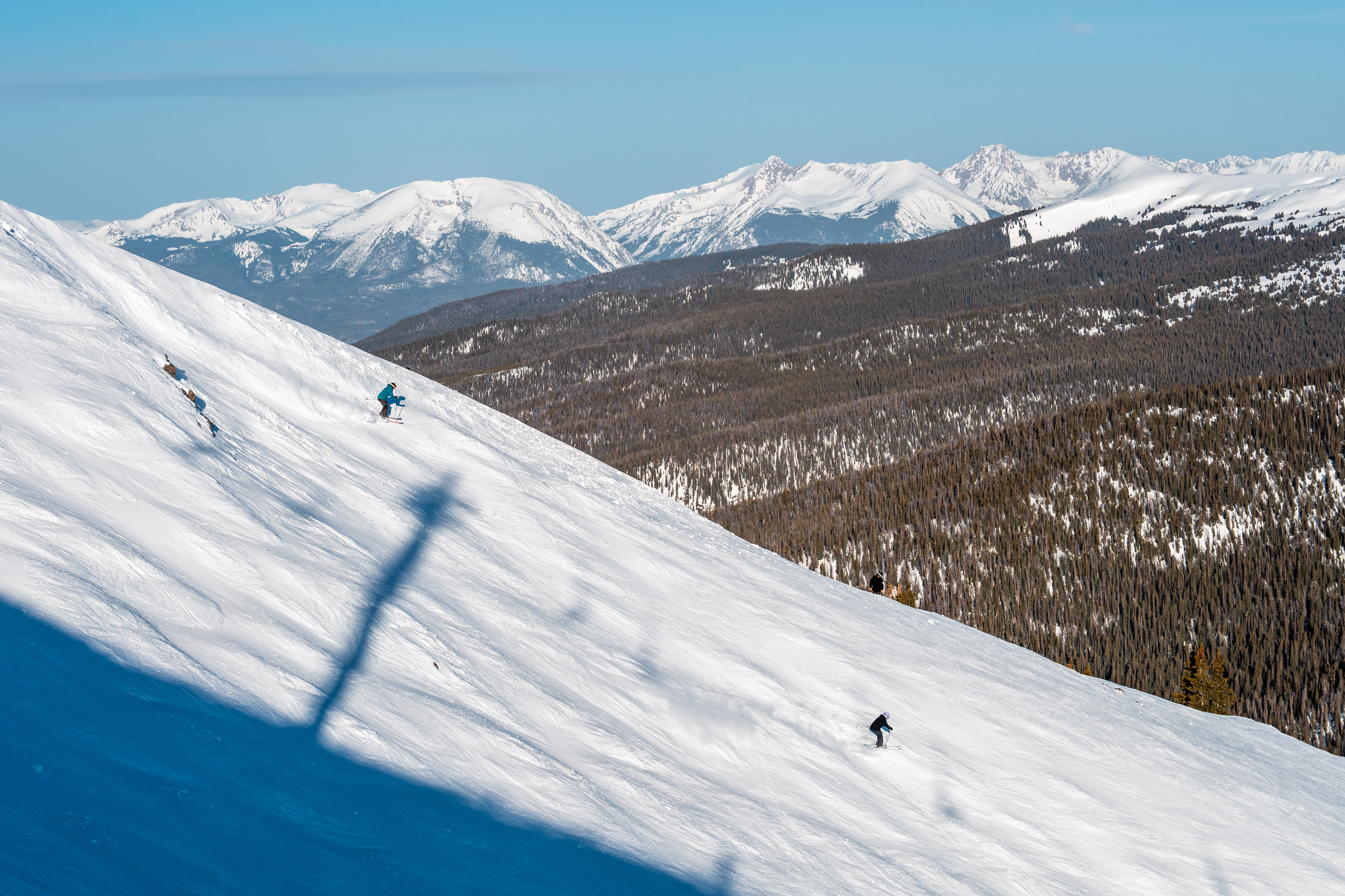
High temperatures on Saturday reached into the low 50s at places like Copper Mountain and Snowmass. High temperatures on Sunday were much lower, however, as a cold front passed through Colorado over night along with snow showers that developed in the afternoon and evening.
Around sunset Sunday, snow was falling moderately at Mary Jane, as seen on the Lunch Rock web camera, with the James Peaks shrouded in white and not visible across the valley.

Six more ski areas and resorts closed for winter 2024-25 operations as well — Aspen Highlands, Beaver Creek, Cooper, Echo, Monarch, Silverton — leaving only 11 areas opening heading into mid-April.
Forecast:
• A cold front pushed through overnight Sunday bringing snow and rain to northern Colorado by early afternoon in the northern mountains north of Interstate 70 mostly.
On Monday, snow will continue through early afternoon, with snowfall totals in the northern mountains forecast to be between 1-4 inches with the highest amounts along the Continental Divide and in the Front Range Mountains. The central just south of I-70 should receive between 1-2 inches and the southern mountains most likely no accumulations at all.
• On Tuesday afternoon, forecast models have snow developing in the southern mountains, with between 1-3 inches falling by Wednesday morning, and perhaps some flakes will fall in west-central Colorado as well.
• On Wednesday afternoon, snow redevelops in the north and central mountains through early Friday morning before spreading across all three mountain zones by Friday early afternoon.
Snow accumulations for Thursday’s first chair in the northern mountains are between 2-4 inches, in the central mountains between 2-4 inches and in the southern mountains between 1-3 inches.

• On Thursday, snow is forecast to intensify from a two-piece, complex storm evolving across the Four Corners region (Storm #1) and a cut-off low hovering over Idaho (Storm #2). Storm #2 is forecast to mostly absorb Storm #1, with parts of Storm #1 pushing eastward from Storm #2’s counter clock wise spin.
The European model has these two storms combining over southern Utah and northern Arizona, forming one larger area of low pressure.
• The newly formed larger storm will hover over the desert southwest through Saturday afternoon before quickly pushing eastward into News Mexico late Saturday night into Sunday morning. The low pressure system is forecast to be in Nebraska by early Monday morning.
Snowfall totals by Monday morning from this storm could be substantial, with up to 12 inches in the northern mountains, up to 18 inches in the central mountains and 12 inches in the southern mountains.
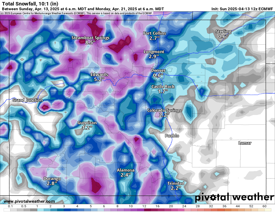
The Euro model forecasts the northern mountains to receive the brunt of the storm for Friday and Saturday morning and the central mountains for Saturday. For Sunday, the southern mountains, along with the other two mountain zones, finally get a good shot of snow for first chairs.
Temperatures associated with this storm are forecast to be mostly below freezing at the base areas and upward, so the potential for snow to fall all across the entire mountain is good. It is April after all, however, so midday temperatures at the lower elevation bases could be very wet snow or a mix of rain and snow.
• Friday, Saturday, Sunday and even Mondays should all be some kind of powder skiing and riding days.
Long-term forecast:
• Snow continues Monday night through Wednesday, April 23 morning in the northern, central and northern southern mountains.
More details about this stormy period will become more clear as the dates near, including snowfall totals, duration and timing.
Today’s 24-hour snow totals for Colorado ski resorts:
Arapahoe Basin – 2″
Aspen Highlands – Closed for the season
Aspen Mountain – 0″
Beaver Creek – Closed for the season
Breckenridge – 1″
Buttermilk – Closed for the season
Cooper – Closed for the season
Copper Mountain – 1″
Crested Butte – Closed for the season
Echo Mountain – Closed for the season
Eldora Mountain – 3″
Granby Ranch – Closed for the season
Hesperus – Closed for the season
Howelsen Hill – Closed for the season
Kendall Mountain – Closed for the season
Keystone – Closed for the season
Loveland – 1.5″
Monarch – Closed for the season
Powderhorn – Closed for the season
Purgatory – 0″
Silverton – Closed for the season
Snowmass – 0″
Steamboat – 0″
Sunlight – Closed for the season
Telluride – Closed for the season
Vail – 0″
Winter Park – 1″
Wolf Creek – Closed for the season
Get OutThere
Signup today for free and be the first to get notified on new updates.
PREV
PREVIOUS
Ron DeSantis’s political future: A president in waiting or a man who missed his shot
Gov. Ron DeSantis (R-FL), once a rising star in the Republican Party, is staring down a pair of decisions in 2026 and 2028 regarding his family’s political future that could both run afoul of fellow Floridian President Donald Trump. Despite a disastrous 2024 presidential campaign, DeSantis, a popular governor, is a rumored candidate for a 2028 […]

Denver weather: Clearing Monday afternoon after overnight snow
Winter storm warnings in effect for eastern Plains and Front Range mountains