


Nuclear waste site near Rifle gets water seepage mitigation
Radioactive waste from two mill sites near Rifle sealed in engineered disposal cell
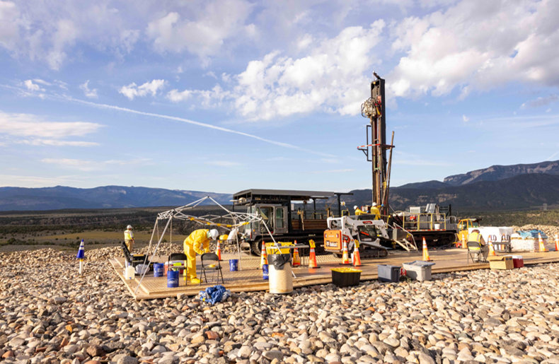
A 71-acre radioactive waste disposal site 6 miles north of the city of Rifle containing uranium mill components and mill tailings from two uranium and vanadium mill sites has been fully remediated by the U.S. Department of Energy Office of Legacy Management, according to a release from the agency.
The site was built in 1996 to permanently sequester radioactive contaminants and equipment from two mill sites operated from 1924 to 1958 that were located adjacent to the Colorado River and the town of Rifle. The mills processed uranium and vanadium. Vanadium is a metal used to strengthen steel. Uranium mined in Colorado was used for the war effort during WWII and post-war nuclear reactors. The site started being flooded by water seeping into the containment cell in 2021.
The disposal site is capped with a multi-layer system designed to keep water out and heavy riprap on top to prevent erosion. The cap is designed to last 1,000 years, according to the release.
It is unclear if the contaminated material lies directly on the underlying Wasatch rock formation — said by the DOE to be impermeable to water — or if there is another impermeable liner under the material.
The disposal cell was supposed to dry out, and an evaporating pond was built to take care of any short-term drainage. But DOE officials said the water never stopped seeping and is rising within the cell, threatening its integrity, so the agency undertook a program of drilling wells that will pump out any seepage and send it to a larger set of evaporation ponds below the disposal cell.
The agency is still investigating why and how seepage is entering the cell.
“Once we realized that our existing infrastructure was not keeping up with the rising water levels, the first approach was to look at modifying operational parameters to maximize pumping rate,” said Team Lead Paul Kerl in the release. “We redeveloped existing wells and we freeze-proofed existing infrastructure to maximize run time and pump year-round, but unfortunately, that still wasn’t enough. Seeing the water levels rising further, we assessed the risks associated with saturating the side slope of the disposal cell and realized a full court press was needed to implement a priority project to mitigate the risks in very short order.”
Team hydrologists created a water flow model and used LIDAR measurements to locate new wells to avoid drilling into buried equipment.
“To simulate how the water levels within the cell would change because of pumping, we developed a numerical groundwater flow model,” said LMSP Senior Hydrogeologist Pete Schillig. “Historically, what we knew about the cell came from three locations: the two standpipes with 30 years of water level records, plus one that’s dry. That didn’t give us a lot of information to calibrate a single groundwater flow model.”
The plan added 10 additional extraction wells, totaling 12 wells actively drawing water from the cell. An additional four monitoring wells were drilled to measure water levels in the cell, according to the release. The new pumping system required the installation of a solar panel array to power the pumps and monitoring systems.
The additional water removal meant more evaporative capacity was needed, too.
“The site was originally built with one small evaporative pond, but we needed to install two additional one-acre modular evaporation ponds to support the volume of pore water to be extracted from the cell,” said LM Site Manager Mary Young in the release.
The agency said work on the site is complete, and the wells are working as expected, extracting water necessary to maintain cell integrity. Site monitoring using data collected and transmitted remotely and adherence to the long-term surveillance plan will continue to protect human health and the environment.

Get OutThere
Signup today for free and be the first to get notified on new updates.
PREV
PREVIOUS

Broncos draft picks Bryant, Jones, Robinson, Crawshaw agree to contract terms
The Broncos are busy locking up their draft picks before the start of Friday’s three-day rookie minicamp. Sources said Wednesday the Broncos have agreed to terms with wide receiver Pat Bryant, a third-round pick from Illinois, defensive end Sav’ion Jones, a third-round selection from LSU, outside linebacker Que Robinson, a fourth-round pick out of Alabama, […]
Colorado snowfall totals from May 6 storm, one location neared 3 feet
An early-May snow storm dropped more than a foot, to two feet, of snow along Colorado’s eastern Front Range mountains from Fort Collins to Colorado Springs and in southern Colorado’s San Juan and Sangre de Cristo mountains. The spring snow storm started delivering snow Monday night in the southern third of the state and by […]