


Narrow vertigo-inducing land bridge offers one-of-a-kind adventure in remote Colorado
Remote. Rugged. Rewarding.
It was July of 2017 and I had just parked my tiny coupe at the end of a long, gravel road in the middle of the Flat Tops Wilderness. It had been a bumpy ride to the trailhead from Yampa, Colorado, but I made it.
Massive plateaus stretched into the sky, creating a horizon-esque ridge-line that wrapped around me.
I was at the start of the Devil’s Causeway Loop trail with plans to travel the route in the clockwise direction. In short, it’s a 10-mile route that gains close to 2,000 feet in elevation. The real draw of this remote trek, however, is its namesake terrain feature – The Devil’s Causeway – a narrow and exposed land bridge as slender as three feet wide at certain rocky spots. It also happens to be located at roughly 11,800 feet above sea-level, meaning the route can come with challenges related to a lack of oxygen and tumultuous weather patterns, too.
Flanked by sheer cliffs of 60-80 feet that end directly above steep talus slopes of several hundred more feet, the route is precarious enough to be fitting of its devilish name. While accidents on the route are uncommon, many that track it down feel compelled to turn back without crossing.
My trek that day began in a lush valley that was full of life. Birds were chirping. Flowers were in bloom. Snow melt still dripped down from the hillside, revealing emerald green slopes while filling numerous tiny ponds. The scene could have been capable of inspiring the line “over the river and through the woods.” It was a natural setting so idealistic that it demanded appreciation.

Flowers found trailside during the trek to the Devil’s Causeway. Photo Credit: Spencer McKee
Following the first segment of the dirt trail, hikers quickly lose sight of the makeshift parking lot around an early bend and it’s impossible to ignore the remote nature of the Flat Tops Wilderness after that.
The route gradually leads hikers toward the uniform ridge-line that inches closer from above on a trail that’s steeper in some sections, but not steep enough to be a deterrent to most.

One of the many great views along the trail to the Devil’s Causeway. Photo Credit: Spencer McKee.
Eventually, treeline is hit, and shortly after, the ridge-line of a large plateau is reached. Be warned that snowfields tend to accumulate below this ridge, making the route difficult to follow if no tracks are visible – one reason why it’s important to be familiar with the general path of the route beforehand.
This final push leads to the second most rewarding part of this hike – the reveal of a massive plateau.
Upon reaching this point and clamoring over the ridge, it suddenly feels as if you’re standing in the middle of a grassy field that stretches for eternity. This sensation only amplifies as continuing along the trail pulls one further away from the cliffed edge left behind. It’s silent. It’s still. It’s serene.
On a cloudy day, the vast sky seems to push down from above, with clouds feeling close enough to grasp. There’s no movement in any direction, after all, the wind-scraped plateaus don’t offer much of a chance for vertical growth. Aside from tiny blades of grass whipping in unison and the occasional high-elevation rodent, there’s not much going on up there – and that’s being said in the most positive light possible.
This portion of the hike feels a bit strange. It’s out of the ordinary. Even if one has explored alpine tundra before, there’s a good chance it wasn’t as flat or vast. Being on top of a plateau in the Flat Tops Wilderness can have one feeling as if they’ve somehow stumbled onto the top of the world. In a similar way, it can feel like discovering an edge of the earth.
The route continues across the plateau for some time along a narrow not-too-trodden path beaten down by inconsistent use over the decades.

A look at the trail across the plateau. Photo Credit: Spencer McKee
Of course, this portion of the hike is where truly dangerous risks can start to rear their head. Big afternoon storms tend to roll in fast, often filled with deadly lightning, perpetual hail, and ground-ripping winds. And remember, the flat nature of the plateau means basically no cover in sight.
After wandering across the plateau’s tundra for an hour or so, the cliffs start to move into a flanking position alongside the trail. And when the cliffs get closer, it means the Devil’s Causeway is approaching, too.
The first thing that can be noticed about this land feature during the approach is how the green of the plateau seems to simply fall away around it, giving way to a jagged, rocky path, with sheer drop-offs and seemingly questionable stability.

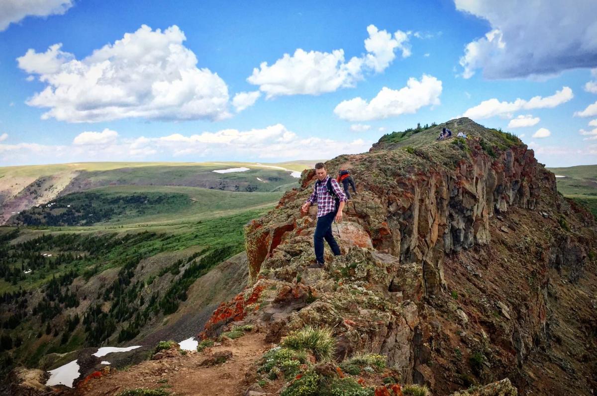
Spencer McKee on a narrow section of the Devil’s Causeway Trail.
Upon getting closer, it can be realized how uneven and narrow the path gets. While there’s still enough room on the Devil’s Causeway to walk it with little risk, a trip could mean death.
Crossing the Devil’s Causeway isn’t inherently difficult. Anyone who has made it that far into the hike should technically be able to complete this portion of the route. Granted, there’s a psychological aspect of crossing the landbridge, too.
When I reached the Causeway, there were a number of people that had made the shorter out-and-back trek up the other side of the loop that I was on. With the narrow land bridge between them and me, a majority of these people weren’t crossing. They were taking pictures and turning around without walking within 10 feet of the surrounding ledges.
While I’d venture to say that most people would be able to overcome the nerves that rear up during this more intense portion of the route, those who struggle with a fear of heights or are risk averse might want to stay away. Like I mentioned, a fall would probably mean certain death, and the middle of the Devil’s Causeway isn’t a great place to freeze up.
As I crossed the land bridge, I noticed a few things that I wasn’t expecting. First, it was a lot more uneven than it appeared in some pictures – so uneven that there were definitely portions where I preferred to use my hands for added stability.
Second, there was ice. Even though it was a weekend around the 4th of July, some of the rocks on the land bridge still had slick spots. That’s definitely something worth noting, as this means that bringing a traction tool would probably be a good idea. Third, the land bridge was mildly breezy as I crossed. I lucked out. Some accounts of Devil’s Causeway crossings indicate extremely high wind, likely thanks to the flat nature of the surrounding terrain and the Causeway’s position on a ridgeline. I have no doubt that gusts that occasionally blast over this ridge could be capable of knocking someone off balance, ripping one off of the bridge and onto the rocks many feet below.
After crossing the bridge on the clockwise loop, the trail is mostly smooth sailing back to the parking lot. There’s immediately a steep section of loose and potentially muddy terrain, but after that it’s more of the picturesque “over the river and through the woods” setting again until the return to the trailhead.
A one-of-a-kind hike that appeals to the adventurous side of the soul, the Devil’s Causeway loop is a rewarding trek through some of Colorado’s most pristine wilderness terrain. Those looking for a day trip adventure can find it here.
Read more about the Flat Tops Wilderness here.
It’s also crucial to note that while following the best practices of Leave No Traces are important during any Colorado adventure, it’s absolutely crucial on this hike given the remote nature of the terrain. Learn more about the seven principles of Leave No Trace here.
Get OutThere
Signup today for free and be the first to get notified on new updates.
PREV
PREVIOUS

Looking back on my 500-mile one-day motorcycle ride around Colorado's central mountains
Facebook Twitter WhatsApp SMS Email Print Copy article link Save Facebook Twitter WhatsApp SMS Email Print Copy article link Save It was somewhere around 11,670 feet of elevation – amid a cramping leg and with storm clouds on the horizon – that I started to wonder if I had made a terrible mistake. Months prior, […]

LOOKING BACK: 'Balloon Boy Hoax' of 2009 had eyes around the world watching Colorado
Facebook Twitter WhatsApp SMS Email Print Copy article link Save Facebook Twitter WhatsApp SMS Email Print Copy article link Save A silver, saucer-shaped balloon floated over Colorado on October 15, 2009, capturing the world’s attention as it was believed to be carrying a six-year-old boy. The incident started when Richard Heene, an amateur scientist in […]