


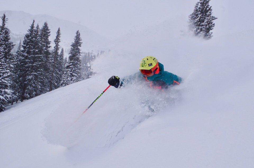
Latest snow storm headed for Colorado downgraded, but 2-8″ of snow still forecast
Snow storm three of three will enter Colorado Sunday afternoon/evening and bring colder temperatures and more snow to the state’s high country through Monday.
Snow making continues at the ski areas as opening date rumors swirl in the air ahead of Halloween; looking at you Keystone and A-Basin.
Next snow storm trending toward at least two weeks out, meaning the start to November will be pretty dry.
Recap:
Snow began falling in Colorado’s mountains on Thursday at places in southern Colorado like Wolf Creek and Telluride to start off the day.
The central and northern mountains began receiving snow later in the day with snowfall accumulations of between 1-3 inches.
Snow continued into Friday, mostly south of U.S. Highway 50 (central mountains), with some lingering showers along the Continental Divide in the Front Range and around Steamboat in the Park Range.
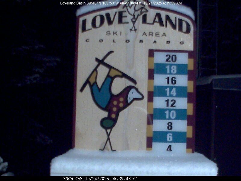
By Friday morning, Loveland Ski Area in Clear Creek County showed 4 inches of fresh snow on its snow stake around 6 a.m. Similar totals were recorded at other northern mountains ski resorts, where 1-6 inches (Vail and Beaver Creek) fell overnight into Friday.
By Friday afternoon, where any additional snow falling was between 1-2 inches, the storm had exited the state but the last storm of three forecast entered the Pacific Northwest.
Forecast:
From Saturday morning until Sunday evening, forecasted conditions around Colorado will be pretty quiet as the third storm moves closer to the state from the Pacific.
High temperatures at base areas over the weekend are forecast to be in the low 40s, with highs at ski area summits in the 30s.
Starting Sunday evening, the ECMWF forecast model run from Friday afternoon forecasts snow returning to Colorado, this time like previous forecasts, mostly for the northern mountains.
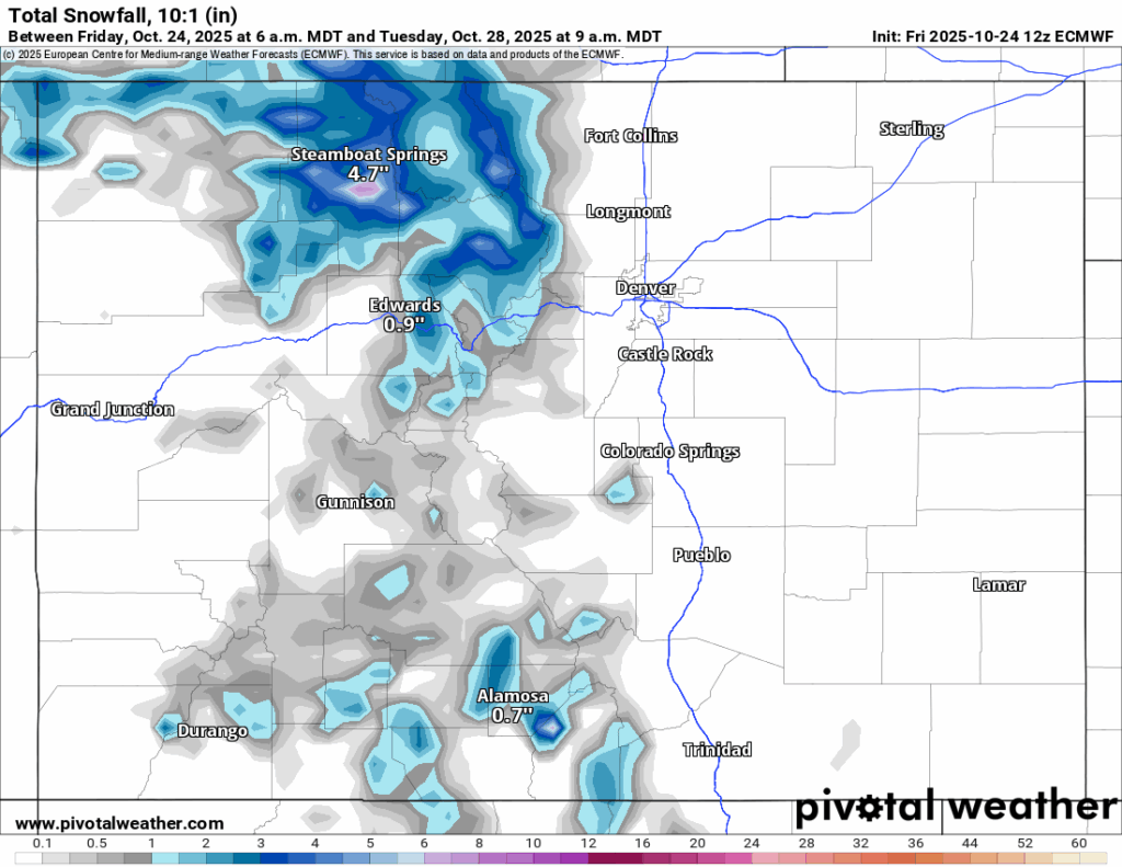
The newest model run has snow falling into Monday evening, with between 2-8 inches accumulating, highest amounts possible mostly in the Park Range around Steamboat.
This change in the forecast is unfortunate from the last few days’ forecast where more widespread snowfall and higher totals was predicted.
One silver lining, however, is that temperatures will be noticeably colder with this storm system, creating better conditions for snow making to commence at ski areas with that equipment and lead to opening days before Halloween.
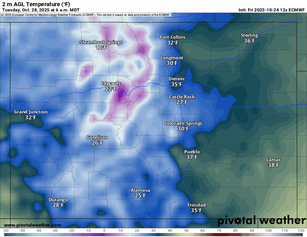
According to the ECMWF model, low temperatures on Tuesday morning, especially in the central and northern mountains, are forecast to be well below freezing.
Wednesday morning’s forecasted low temperatures are similar, however, more widespread across the entire state, which could lead to additional snowmaking during the first several days of next week.
Long-range forecast:
From Wednesday through Tuesday, Nov. 4, little to no storminess is forecast. On Wednesday, Nov. 5, the possibility of snow is in the mix for the northern mountains, and then again starting Saturday, Nov. 8.
More model runs will have to render to dial in better details regarding these two potential snow events, but currently the dates are 10-plus days out and could certainly change over the course of time period.
Colorado ski resorts’ planned opening dates:
Arapahoe Basin – Open as soon as conditions allow
Aspen Highlands – Dec. 13
Aspen Mountain – Nov. 27
Beaver Creek – Nov. 26
Breckenridge – Nov. 7
Buttermilk – Dec. 13
Cooper – Dec. 10
Copper Mountain – Nov. 7
Crested Butte – Nov. 26
Echo Mountain – TBD
Eldora Mountain – Nov. 14
Granby Ranch – Nov. 26
Hesperus – Closed for the season
Howelsen Hill – Nov. 29
Kendall Mountain – December
Keystone – Open as soon as conditions allow
Loveland – Open as soon as conditions allow
Monarch – Nov. 21
Powderhorn – Nov. 22
Purgatory – Nov. 22
Silverton – Private mountain after Dec. 1, Guided and Heli season Dec. 27
Snowmass – Nov. 27
Steamboat – Nov. 22
Sunlight – Dec. 12
Telluride – Nov. 27
Vail – Nov. 14
Winter Park – Open as soon as conditions allow
Wolf Creek – Open as soon as conditions allow

‘Coolest thing made in Colorado’ this year? A shipping container farm
Bernadette Berdychowski
bernadette.berdychowski@denvergazette.com
Updated 7 hours ago
A company specializing in vertical farming was awarded the “2025 Coolest Thing Made in Colorado” by the Colorado Chamber of Commerce on Thursday. The statewide business lobbying group celebrated the top inventions of the state for the past four years...
Bernadette Berdychowski
Reporter

Aided by a new sponsor, the Broadway Halloween Parade returns Saturday
Michael Braithwaite
michael.braithwaite@gazette.com
Updated 6 hours ago
With All Hallows’ Eve just around the corner, South Broadway will soon become a meeting point for Denver’s population of ghouls, ghosts and otherworldly spirits. The ever-popular Broadway Halloween Parade will be back Saturday evening, featuring more than 80 parade...
Michael Braithwaite
Reporter
AI for hotel pricing? Boulder startup sees room for opportunities in industry
Bernadette Berdychowski
bernadette.berdychowski@denvergazette.com
Updated 8 hours ago
When Matt Schwartz was pitching the idea for a hotel pricing company that uses artificial intelligence to a industry vendor visiting Denver several years ago, he recalled how excited the vendor was at the thought. Many hotels do the math...
Bernadette Berdychowski
Reporter

New charitable gaming board meets following Gazette series
David Migoya
david-migoya@denvergazette.com
Updated 5 hours ago
The latest iteration of Colorado’s long-defunct advisory board for charitable gaming met Friday for the first time since legislators revived it more than 18 months ago. The Charitable Gaming Board did little more than elect its chairman, Maytham Alshadood, the...
David Migoya
Reporter
Majority of Colorado hospitals operating on ‘unsustainable’ margins, report finds
Marissa Ventrelli
marissa-ventrelli@denvergazette.com
Updated 6 hours ago
Nearly 70% of Colorado hospitals ended 2024 with “unsustainable” margins, according to a new financial report by the Colorado Hospital Association. Tom Rennell, CHA’s senior vice president of financial policy and data analytics, said hospitals’ expenses are outpacing their revenue...
Marissa Ventrelli
Reporter

Denver City Council to hear from public on mayor’s proposed budget
Deborah Grigsby
deborah.smith@denvergazette.com
Updated 6 hours ago
Monday’s Denver City Council meeting will likely be a long night. Council members will hold a required public hearing on Mayor Mike Johnston’s proposed 2026 spending plan. City officials note that on budget hearing night, the number of people providing...
Deborah Grigsby
Reporter

Denver area events for Oct. 25
Carlotta Olson
carlotta-olson@denvergazette.com
Updated 11 hours ago
If you have an event taking place in the Denver area, email information to carlotta.olson@gazette.com at least two weeks in advance. All events are listed in the calendar on space availability. Saturday Hauntings in the Hanger — Trick-or-treat candy stations, scavenger hunt,...
Carlotta Olson
Reporter
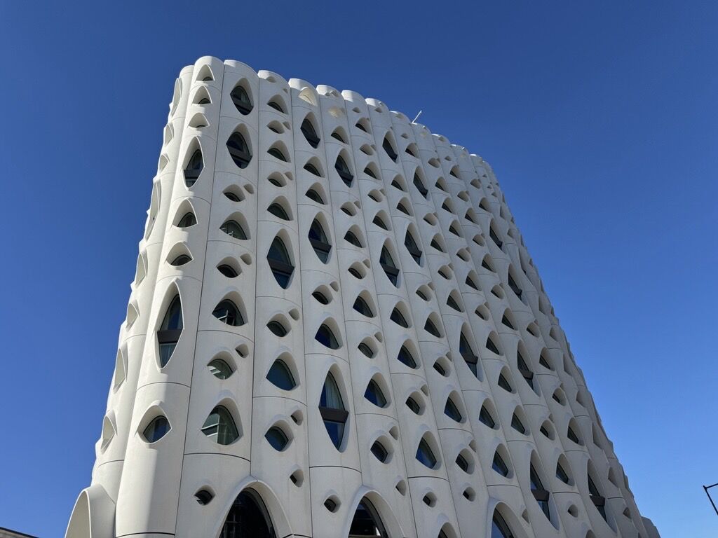
Populus Hotel in Denver fined for pest control issues
9News
9news@denvergazette.com
Updated 9 hours ago
Earlier this month, Michelin recognized the Populus Hotel, in downtown Denver, as one of “The very best hotels in the United States.” Denver public health inspectors also recognized something this summer: pest control violations. The Denver Department of Public Health...
9News
Reporter
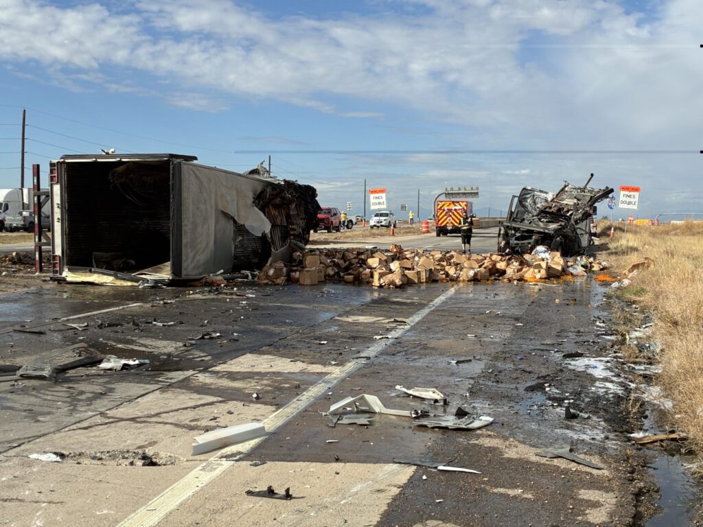
Interstate 70 reopened after separate vehicle crashes closed stretches of highway
Michael Braithwaite
michael.braithwaite@gazette.com
Updated 7 hours ago
A 3-semi-truck crash in Aurora and a vehicle fire near Genesee Hill contributed to the mayhem Interstate 70 reopened to traffic after two separate vehicle crashes closed sections of the highway on both sides of metro Denver Friday morning. On...
Michael Braithwaite
Reporter
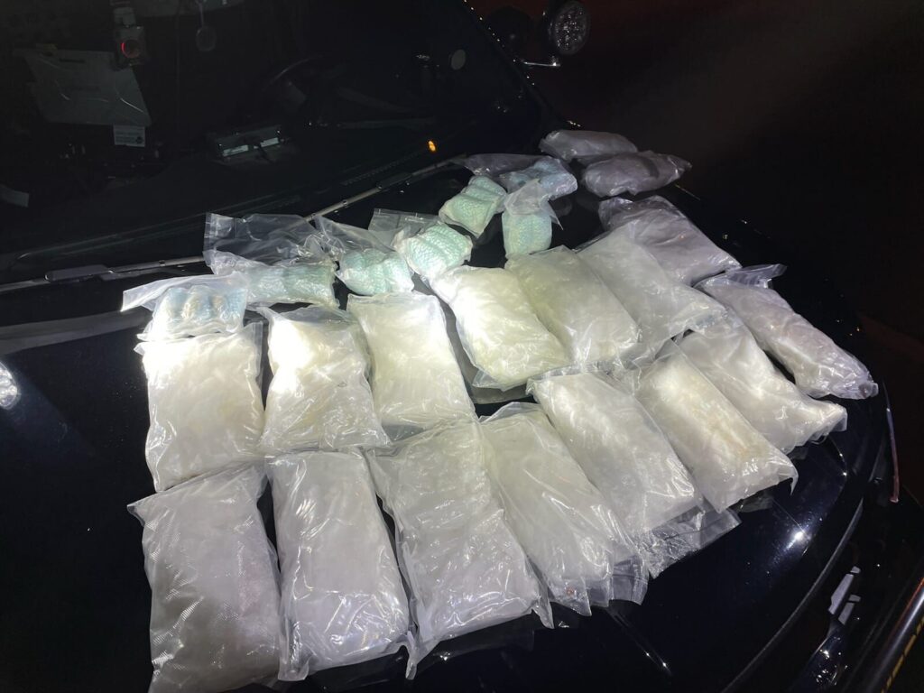
Adams County officials seize 70 pounds of methamphetamine, 5 guns during traffic stop
Michael Braithwaite
michael.braithwaite@gazette.com
Updated 7 hours ago
Adams County officials, in collaboration with several other law enforcement agencies, seized a swath of drugs and firearms during a traffic stop and search warrant execution last week. Collected during the operation were 70 pounds of methamphetamine, 1.29 kilograms of...
Michael Braithwaite
Reporter
PREV
PREVIOUS

Majority of Colorado hospitals operating on 'unsustainable' margins, report finds
Nearly 70% of Colorado hospitals ended 2024 with “unsustainable” margins, according to a new financial report by the Colorado Hospital Association. Tom Rennell, CHA’s senior vice president of financial policy and data analytics, said hospitals’ expenses are outpacing their revenue as an increasing number of Colorado patients are losing their insurance coverage, partially due to […]
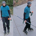
Boulder police seeking help in finding inline skating hockey stick attacker
Boulder police are asking for the public’s help in finding a suspect who couldn’t keep his aggressive forecheck inside the barn. The suspect, reported to be a white man of medium-tall height and a slender build on inline skates, attacked a bicyclist with a hockey stick near 27th Way and Baseline Road Thursday, according to […]