


Wash Park neighbors celebrate a compromise in ‘road diet’ plan for Alameda

Neighbors in Washington Park took a victory lap Friday after Denver’s Department of Transportation and Infrastructure agreed to modify plans for a “road diet” that would have narrowed traffic along a heavily used stretch of East Alameda Avenue.
The neighborhood group Act for Alameda told The Denver Gazette that a Thursday meeting with DOTI officials and a representative from Mayor Mike Johnston’s office yielded substantial changes in what had been a plan to cut the flow of traffic from four lanes to two along the busy thoroughfare.
DOTI confirmed it had adjusted its “lane repurposing project” along Alameda to leave two lanes of eastbound traffic intact, while narrowing westbound traffic for a mile-long expanse from South Humboldt to South Pearl Street to a single lane. That will allow for designated left-turn lanes to be installed, feeding streets south of the avenue.
“They really have listened,” said Lowry resident Rye Austin, a regular commuter along the stretch, who spoke on behalf of Act for Alameda about DOTI’s new accommodations to the plan.
“They were open to a solution that balances safety and neighborhood character,” he added. “At the end of the day, this is what good community planning looks like.”
The opposition group of residents, commuters and business owners formed last summer after DOTI made plans to move ahead on the Alameda project. Opponents reportedly drew 800 co-signers to a letter to the mayor, voicing that the narrowing could “create substantial and lasting negative impacts on traffic safety, neighborhood livability, and the vitality of local businesses.”
The city had maintained the narrowing project was necessary to improve safety, following what it said was a study of speeding and collisions that were resulting from unprotected left turns across two oncoming lanes of traffic. DOTI had added that it had received community requests for better pedestrian crossings near a school.
Neighbors had countered that the project would likely slow traffic on Alameda, forcing cars to reroute into quiet streets surrounding the boulevard. A city engineer had reportedly admitted during a June meeting with residents that traffic on side streets would increase on east-west Cedar Avenue north of the Avenue, and on East Dakota and Virginia Avenues to the south.
Opposition to the project also drew some business owners, who worried that the slowing would increase incidents of drivers cutting through their parking lots to avoid backups at intersections, something they were already observing. Some also voiced concerns that slimming down traffic on the Avenue would cut into their customer traffic.
Not all neighbors were happy with the announcement.
“I’m personally disappointed with the decision,” Bryant Denning, one of a number of neighbors who had been supporters of the original two-lane plan, told The Denver Gazette.
“I interpret it as prioritizing convenience over the safety of pedestrians in area,” he said. “My general takeaway is that the safety issues we have observed will continue as they are.”
The city had carried out a similar lane reduction project along the same corridor from 2008 to 2010, but had returned it to four lanes of flow after rush-hour backups were cropping up at South Downing Street — the busiest intersection along the stretch.
Following an earlier query from The Denver Gazette, DOTI had said that traffic along the corridor had been greater than 20,000 vehicles per day during the previous project, and that it was now averaging 14,800 vehicles, more suited to a lane partial reduction.
In a news release on Friday, DOTI said it had adjusted the latest design to narrow traffic to a single westbound lane for a 10-block stretch from Pearl Street to Humboldt Street, which would allow it to create designated center turn lanes.
“Providing left turn lane pockets on this stretch is anticipated to reduce vehicle crashes,” the statement said. “Vehicle volumes on Alameda Ave. are lower westbound compared to eastbound, so the potential for congestion and traffic diversion is lower with the lane repurposing in the westbound direction, while the addition of turn lane pockets will increase safety.”
“Providing two travel lanes eastbound will reduce the potential for congestion eastbound and diversion to the side streets,” the statement added.
Also included in the revised plan are implements designed to improve safety for pedestrians and for bike or scooter traffic. Those included a flashing beacon, pedestrian refuge island and marked crosswalks at Franklin Street; new crosswalks at Grant Street; and protected bike-lane approaches and bike crossings at Washington and Emerson streets.
DOTI added that traffic signals would be upgraded at Pearl and Emerson Streets. The speed limit along the stretch will be cut from 30 to 25 miles-per-hour as previously planned. The agency said it expects the design aspects to be completed in mid-2026 and to carry out the actual modifications from late next year to late 2027.
In a separate statement to residents, DOTI said that the “partial lane repurposing” would enhance safety, pedestrian visibility and comfort, while minimizing traffic impacts. The project would include corner reconstruction and ADA ramp upgrades at Emerson, along with safety Improvements on Virginia Avenue and Downing Street to mitigate side street diversions.
Colorado’s outdoor economy is slowing down
Bernadette Berdychowski
bernadette.berdychowski@denvergazette.com
Updated 41 minutes ago
The post-pandemic boom in the outdoor recreation world appears to have slowed, according to new federal data. The industry is still growing nationwide, but it’s been slower than in past years. The trend is evident in Colorado, as well, though...
Bernadette Berdychowski
Reporter

DA asks judge to deny request for Suzanne Morphew’s remains
Carol McKinley
carol.mckinley@gazette.com
Updated 47 minutes ago
A district attorney denied a request from Suzanne Morphew’s daughters on Wednesday to turn over her remains before her husband’s trial. Anne Kelley, District Attorney with the 12th Judicial District, said in a motion that because her remains were lawfully...
Carol McKinley
Reporter
Denver weather: Warm Thursday, but 1-3 inches of snow is coming
Daniel Boniface
dan.boniface@denvergazette.com
Updated 6 hours ago
Warm temperatures are expected in Denver on Thursday, but the snow is on its way, forecasters said. The National Weather Service in Boulder said to expect a high of 68 degrees at Denver International Airport on Thursday. That’s about 16...
Daniel Boniface
Reporter
Will Denver’s dueling underground music fests face off at once?
John Moore
john.moore@denvergazette.com
Updated 2 hours ago
Less than a year ago, local music fans collectively pondered whether the summer music festival might be dead in Denver. (To our credit, we opined in this space: “Categorically not.” Actually, our exact words were: “Don’t be daft, punk!”) But...
John Moore
Reporter
Almost 40 apply for board to oversee revitalization of Colfax Avenue
Kyla Pearce
kyla-pearce@denvergazette.com
Updated 4 hours ago
Aurora officials received almost 40 applications for the Aurora Downtown Development Authority Board that will oversee the revitalization of Colfax Avenue. The application period ended Saturday, and an Aurora spokesperson said 38 people applied. Of the 38 applicants, 32 met...
Kyla Pearce
Reporter
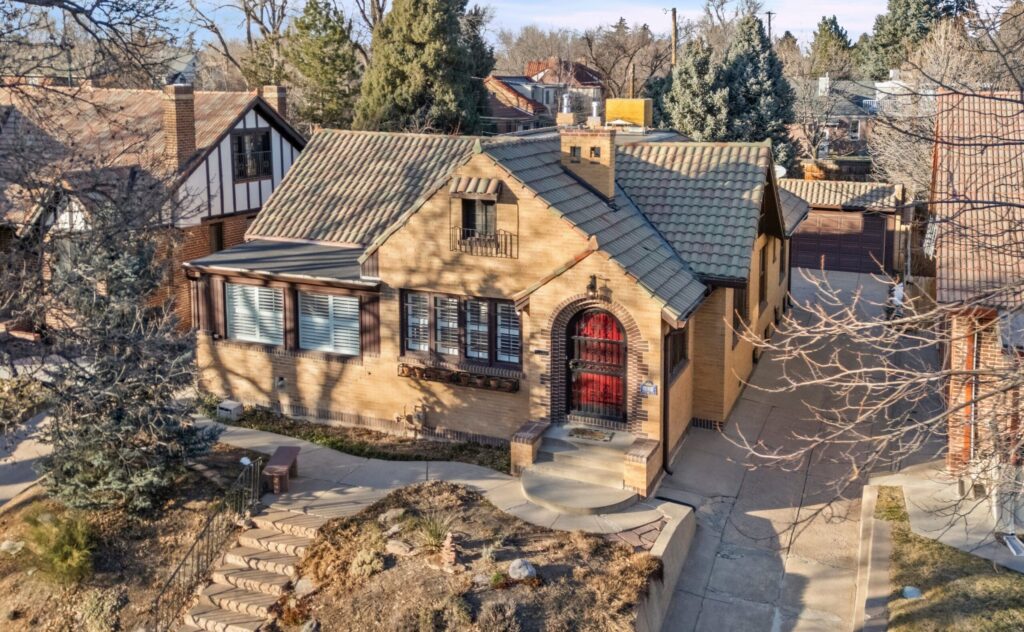
Four blocks from City Park, Tudor ranch has entertaining possibilities
Mark Samuelson
mark.samuelson@denvergazette.com
Updated 6 hours ago
At a moment agents are sensing unusual demand for ranch plans and for others that have a primary suite on the main level, veteran agent Ali Van Westenberg has one of those to show on Denver’s 17th Avenue Parkway, four...
Mark Samuelson
Reporter
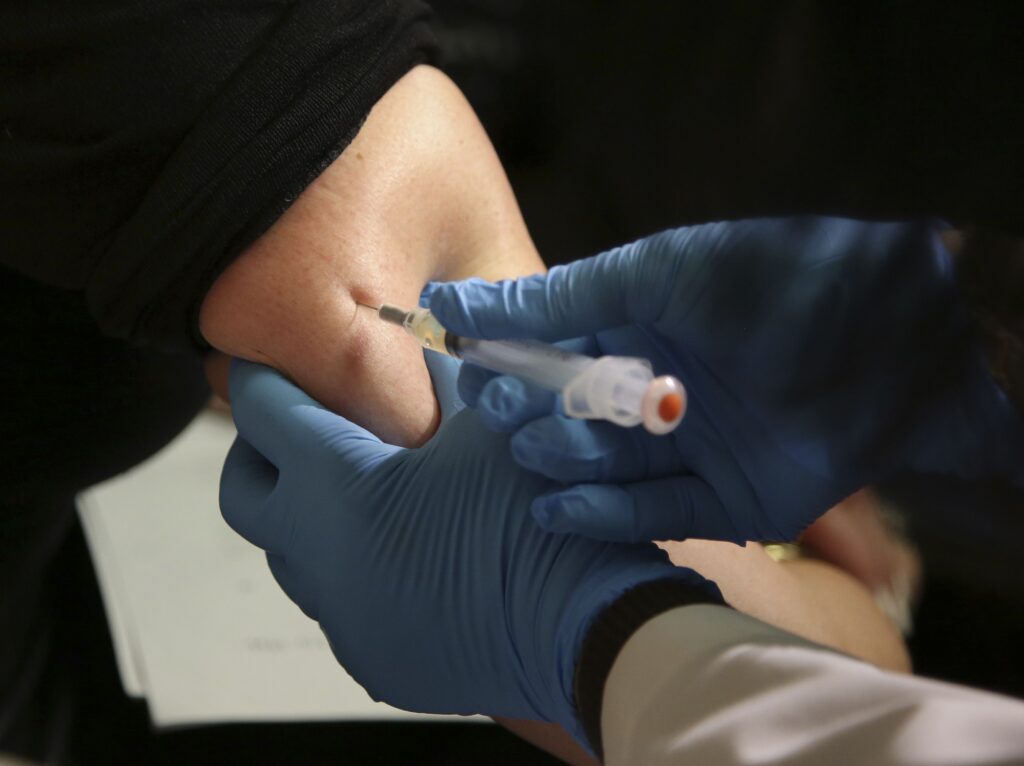
Colorado declares measles outbreak after third case linked to Broomfield school
Nicole C. Brambila nico.brambila@denvergazette.com
nico.brambila@denvergazette.com
Updated 4 hours ago
An unvaccinated Adams County child who tested positive for measles is tied to a case from Broomfield High School last month, leading state health officials to declare an outbreak. Colorado has four measles cases to date, amid a national outbreak....

Federal audit finds $77.8M in improper Medicaid payments for Colorado autism therapy
Nicole C. Brambila nico.brambila@denvergazette.com
nico.brambila@denvergazette.com
Updated 4 hours ago
Colorado’s Medicaid payments for a therapeutic program for individuals with autism increased 172% in four years, prompting a federal audit by the Office of the Inspector General. Auditors found Colorado made $77.8 million in improper Medicaid payments for Applied Behavior...

Denver police chief on mask ban, mayor’s orders: ‘What enforcement looks like, I’m not exactly sure’
Deborah Grigsby
deborah.smith@denvergazette.com
Updated 7 hours ago
Denver bans wearing of face masks by law enforcers, use of city property to stage immigration operations As Denver takes steps to restrict federal agents conducting immigration enforcement in the Mile High City, its police chief said he is unclear...
Deborah Grigsby
Reporter
Weekend things to do around Denver: Colorado Golf Expo and more
Emily Bejarano
emily-bejarano@gazette.com
Updated 21 hours ago
No plans for the upcoming weekend? There’s still plenty of action happening around Denver and beyond to get folks off the couch. Each Thursday, explore Denver’s essential weekend events curated by The Denver Gazette. Dive into cultural experiences and entertainment...
Emily Bejarano
Reporter
PREV
PREVIOUS
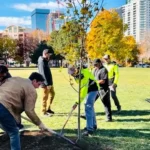
Denver Parks & Recreation meets goal of 4,500 new trees planted in 2025
Before it gets its seasonal blanket of white, Denver celebrated being a bit more green Thursday. As part of the city’s efforts toward meeting its annual climate goals, Denver celebrated its 4,500th newly-planted tree this year, according to a news release from Denver Parks and Recreation. “Projects like this are essential as we continue to […]

Senate rejects bill to fund federal worker pay
WASHINGTON – The U.S. Senate on Friday rejected legislation that would resume paychecks for hundreds of thousands of federal workers during the longest shutdown in U.S. history, as Democrats and Republicans remained at odds over how to reopen the government. The measure received 53 yes votes to 43 no votes in the Republican-controlled chamber, short […]