


18″ of snow could hit some peaks with snow finally possible along I-25 corridor, too
Heads up, Front Rangers, it’s looking like there’s finally a chance of snow along the I-25 corridor for later this week and it comes with a storm that’s also bringing the potential of up to 24 inches of snow to some southwestern Colorado peaks.
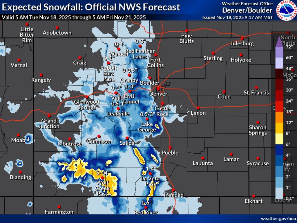
Per snowfall forecast mapping released by the National Weather Service at 9:17 a.m. on November 18, widespread snow should fall this week. That said, the actual accumulations that come with this weather pattern could vary greatly – one scenario meaning a widespread dusting with the exception of the southwest and another scenario pointing to up to a foot of snow on many Colorado mountains.
In the most likely ‘expected’ scenario (80% chance), it’s really only the peaks of the San Juans and Sangre de Cristos that get more than six inches, with upper potential being about a foot through Friday morning. Meanwhile, the peaks of the central mountain region and northern Colorado top out at about four to six inches during this multi-day stretch. The I-25 corridor between Castle Rock and Colorado Springs could also get about two inches, which isn’t much, but could be enough to result in slick conditions and traffic delays.
See this forecast depicted on the map below and keep scrolling for the ‘high-end’ snowfall forecast, which is less likely but would likely come with more significant impacts:
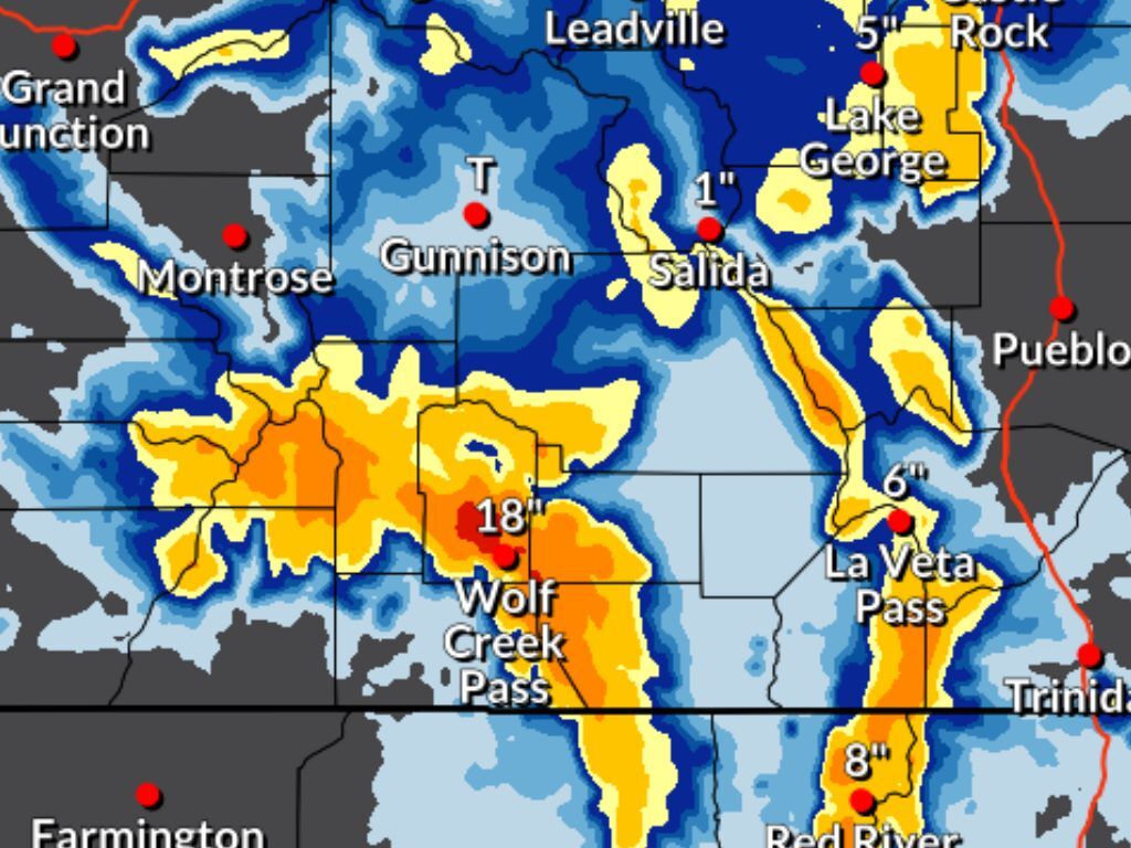
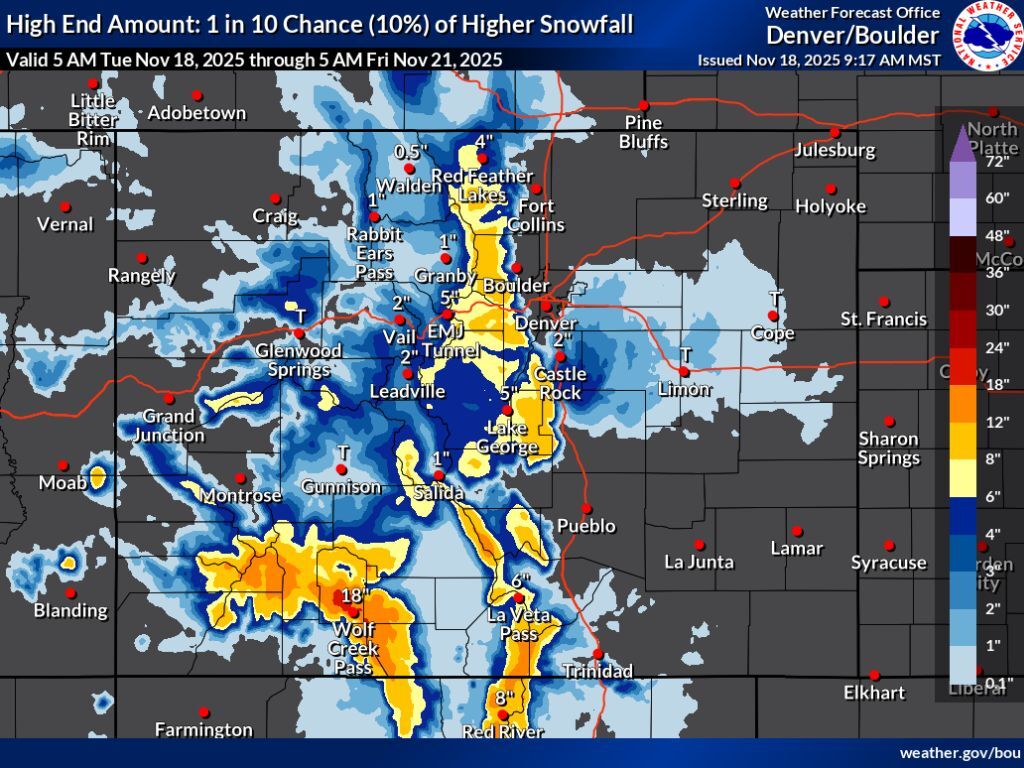
The ‘high-end’ snowfall forecast (10% chance) is where things really start to get interesting.
In this scenario, southwest Colorado could get snow in the range of 18 to 24 inches on some select peaks, specifically those in the area of Wolf Creek Pass. Meanwhile, many of the other peaks in that region and in the Sangre de Cristo range could see snow totals between 12 and 18 inches. This scenario also shows the chance of between eight and 12 inches in the Central Mountains and alongside the I-25 corridor. While these heavy totals aren’t expected directly on this highway – about four inches would fall on the road – watch out for any sort of shift that could have the snow dropping just a bit more east.
See this scenario depicted on the mapping below and keep scrolling for information about how much snow is expected on a few key Colorado peaks:
Let’s take a look at what some other forecasting services are calling for over upcoming days as it relates to skiing and hiking.
As far as the ski resorts are concerned, OpenSnow’s five-day forecast also shows the resorts of the southwest getting hit the hardest, though the OpenSnow prediction is more in-tune with the NWS ‘expected’ snowfall forecast opposed to the ‘high-end’ scenario. Purgatory and Silverton get hit the hardest during this period according to OpenSnow, getting about seven inches of fresh powder. Find the full OpenSnow breakdown here.
As far as some of the state’s fourteeners go, Mountain-Forecast.com calls for about 12 inches of snow on southwest Colorado’s Mount Sneffels through Friday. The same service also shows Pikes Peak getting about 13 inches during the same period.
Statewide, Colorado’s snowpack is at about 30 percent of what’s typical for November 18 – this puts it in the 8th percentile among seasons dating back to 1987.
Follow along with the ever-changing weather forecast on the National Weather Service website, where you can also find alerts and long-term outlooks.
RELATED: Sign up for our free daily newsletter to get top headlines in your inbox
Get OutThere
Signup today for free and be the first to get notified on new updates.
PREV
PREVIOUS

Parachuter dead in Colorado after being spotted in spin with partially open chute
A solo parachuter reportedly died following an incident that took place in Boulder County on November 16. At about 3 p.m. on Sunday, a report was received regarding a parachuter who was found face down in a field northeast of Boulder and just north of Gunbarrel on the 10000 block of N. 75th Street. The […]

Motorcycle reportedly caught traveling more than 70 MPH over speed limit in Colorado
A motorcycle was caught speeding at 116 mph in a 45 mph area near S. Kipling and W. Bowles, according to a social media post from the Jefferson County Sheriff’s Office. The JCSO said that the motorcyclist was caught by a traffic unit deputy on Friday. “The rider now faces a judge who will confront […]