


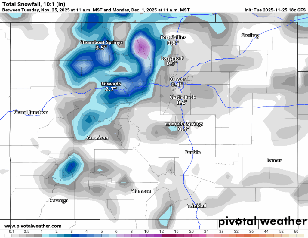
Heavy snowfall in Colorado forecast with 20+ inches possible as December starts
Winter weather systems inbound for Colorado have been evolving more frequently during early winter 2025-26, and the forecasted Thanksgiving system and the ones lining up behind it heading into December are no exception.
Prime example being the Thanksgiving storm. A change to greater snowfall in the northern and central mountains, not the southern mountains, is now forecast for Wednesday into Thursday, and then over the weekend.
But the southern mountains do see the potential for a lot of snow heading into the first week of December as winter storms line up over the first several days to hopefully drop much needed snow on the Centennial state.
Moment of Zen:

Recap:
Snow started falling in northern Colorado around sunset Monday night, and picked up steam heading into Tuesday morning.
Snowfall totals in the northern mountains were to the tune of between 4-7 inches, which was well above the earlier week’s forecast of between 1-2 inches.

Forecast:
On Wednesday, light snow showers return to the northern mountains mainly with between 1-2 inches possible for Thursday, Thanksgiving Day’s first chairs. The central and southern mountains should see no snow fall.
From Thursday to Friday afternoon, dry conditions are forecast, with daytime highs in upper 30s and low 40s and nighttime lows in the teens; snow-making continues at night.
From Friday afternoon/evening, hopefully this forecast holds, snow develops in the northern mountains from the northwest via trough, spreading snow into the central and southern mountains into Saturday morning.
The ECMWF model forecasts more widespread snow accumulations by Saturday morning, where as the GFS model forecasts snow accumulations mostly in the northern third of the state.
ECMWF:
GFS:
Snow returns Sunday as a cut-off low dips into south through Nevada while pushing moisture into Colorado’s western mountains.
By Sunday night/Monday morning, this system should have deposited moderate to heavy snowfall totals in the west-central and central mountains, and southern mountains.
The Euro model forecasts potential totals late Monday morning in the southern mountains between 18-26 inches, in the central mountains and additional 5-9 inches in the west-central mountains and 6-10 inches near the east-central mountains and in the northern mountains an additional 1-3 inches.
The GFS model still has nowhere near the possible snowfall totals as the first day of December starts, but with any luck the Euro model will pan out and Colorado’s high country will receive much needed snow.
ECMWF:
GFS:
Snow is forecast to continue into Tuesday night before the system exits eastward into New Mexico and north Texas.
Long-term forecast:
Overnight Wednesday into Wednesday morning, another system is forecast to approach Colorado from the northwest and bring more snow through Thursday, Dec. 4.
The Tuesday afternoon Euro model has snow confined to mostly the northern and central mountains with this Dec. 4 storm, with potential snowfall amounts between 3-6 inches.
Colorado could be under a high pressure dome after Thursday, Dec. 4 for about six or seven days before any unsettled weather dips southward into the state.
Colorado ski resorts’ planned opening dates and 24-hour totals:
Arapahoe Basin – 2″
Aspen Highlands – Dec. 13
Aspen Mountain – Nov. 27
Beaver Creek – Delayed
Breckenridge – 0″
Buttermilk – Dec. 13
Cooper – Dec. 10
Copper Mountain – 0″
Crested Butte – 0″
Echo Mountain – TBD
Eldora Mountain – 0″
Granby Ranch – 0″
Hesperus – Closed for the season
Howelsen Hill – Nov. 29
Kendall Mountain – December
Keystone – 6″
Loveland – 0″
Monarch – Delayed
Powderhorn – Delayed
Purgatory – Nov. 28
Silverton – Private mountain after Dec. 1, Guided and Heli season Dec. 27
Snowmass – Nov. 27
Steamboat – 0″
Sunlight – Dec. 12
Telluride – Nov. 27
Vail – 0″
Winter Park – 3″
Wolf Creek – 0″

Movie rundown for the weekend through Jan. 18: ’28 Years Later: The Bone Temple’ opens
Carlotta Olson
carlotta-olson@denvergazette.com
Updated 3 minutes ago
OPENING “28 Years Later: The Bone Temple” — (Horror, not rated, 109 minutes). Dr. Kelson discovers something that could change the world, while Spike joins Jimmy Crystal’s gang. “All You Need Is Kill” — (Action, R, 81 minutes). Two people...
Carlotta Olson
Reporter
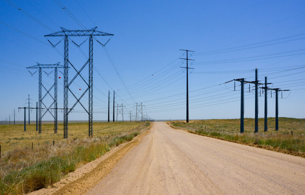
Xcel Energy considers planned outages in northern Colorado due to wildfire risk
Daniel Boniface
dan.boniface@denvergazette.com
Updated 7 minutes ago
Sunny skies and mild temperatures are on tap Thursday for Denver, but breezy winds and low relative humidity have meteorologists concerned about fire danger in Larimer and Weld counties and Colorado’s Eastern Plains. The National Weather Service in Boulder has...
Daniel Boniface
Reporter
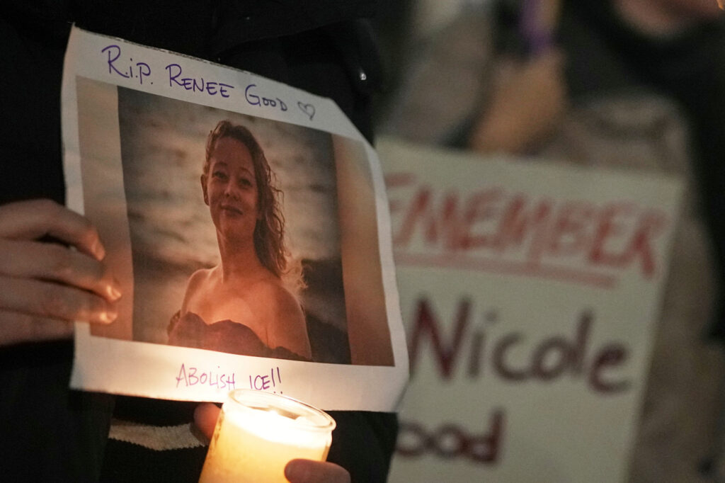
Renee Good’s family hires George Floyd law firm to investigate Minneapolis ICE shooting
The Associated Press
the-associated-press@denvergazette.com
Updated 13 hours ago
Renee Good’s family is accusing federal immigration officers of killing the Minneapolis mother as she attempted to follow agents’ instructions, and said Wednesday they have hired the same law firm that represented George Floyd ’s family to press for answers and accountability....
The Associated Press
Reporter

Weekend things to do around Denver and beyond: Broncos watch parties and more
Linda Navarro
linda-navarro@denvergazette.com
Updated 14 hours ago
Each Thursday, explore Denver’s essential weekend events curated by The Denver Gazette. Dive into cultural experiences and entertainment delights across the city. Whether you enjoy art galleries, pottery, or outdoor sports, there’s something for everyone in Denver’s vibrant cultural scene....
Linda Navarro
Reporter
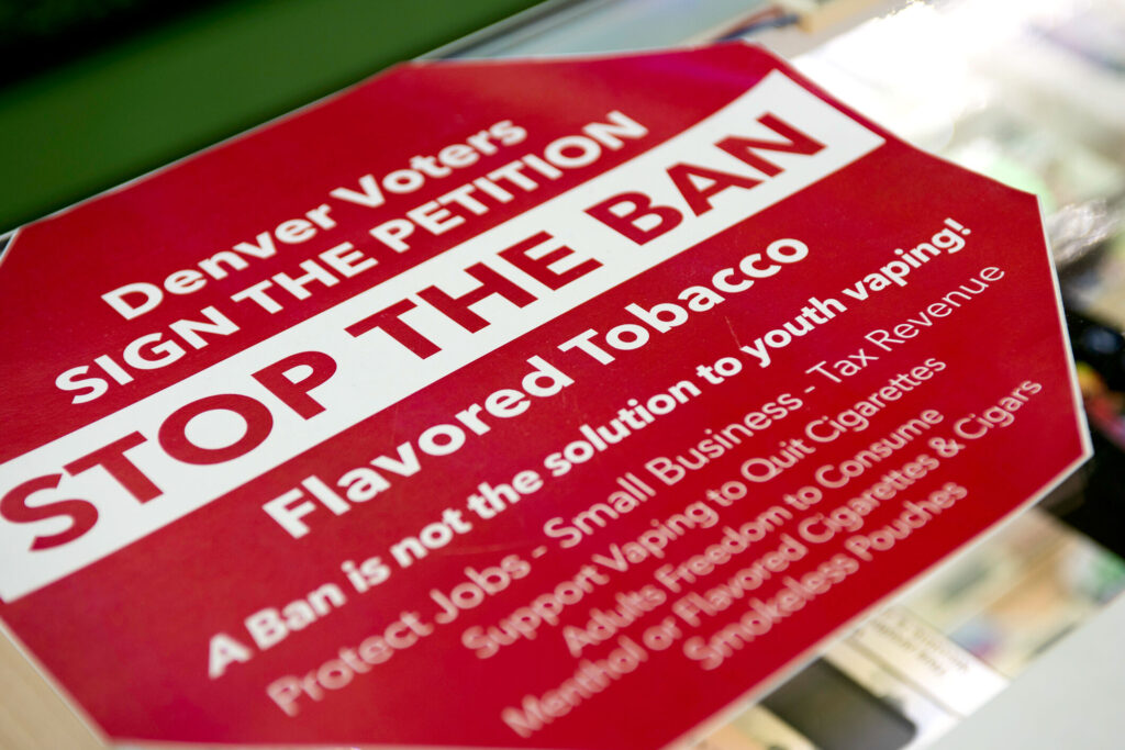
As Denver’s flavored tobacco ban takes effect, retailers face fines, inspections
Deborah Grigsby
deborah.smith@denvergazette.com
Updated 1 hour ago
Enforcement of Denver’s flavored tobacco ban began on Jan. 1 and city officials said that while education efforts will continue, retailers can expect both public-facing and undercover investigations to ensure compliance. The Denver Department of Public Health and Environment is...
Deborah Grigsby
Reporter

Denver’s Jewish Film Festival will range from a rom-com to Elie Wiesel documentary
Mark Samuelson
mark-samuelson@denvergazette.com
Updated 60 minutes ago
Denver’s Jewish Film Festival opens next Thursday, Jan. 22, with a lineup of 40 productions ranging from full-length features to shorts and documentaries portraying Jewish culture, history, and issues. The annual Denver festival, entering its 30th season, draws thousands of...
Mark Samuelson
Reporter
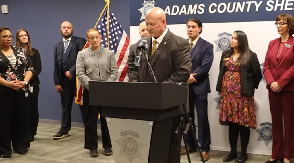
Adams County Sheriff’s Office creates human trafficking unit
Kyla Pearce
kyla-pearce@denvergazette.com
Updated 1 hour ago
The Adams County Sheriff’s Office announced the creation of a Human Trafficking Unit on Tuesday. Two Adams County detectives will staff the unit, investigating human trafficking cases and enforcing regulations governing massage facilities, according to a news release from the...
Kyla Pearce
Reporter
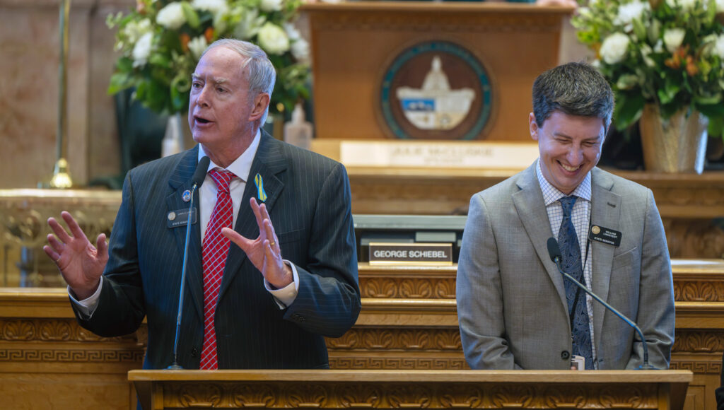
Colorado Senate kicks off 2026 session with bills on competency law, housing, schools and public safety
Marianne Goodland
marianne-goodland@denvergazette.com
Updated 12 hours ago
The Colorado Senate opened the 2026 legislative session Wednesday with a flurry of policy proposals, including changes to the state’s competency law, tougher penalties for child trafficking, early action on school funding and measures addressing housing, firearms and immigration enforcement....
Marianne Goodland
Reporter
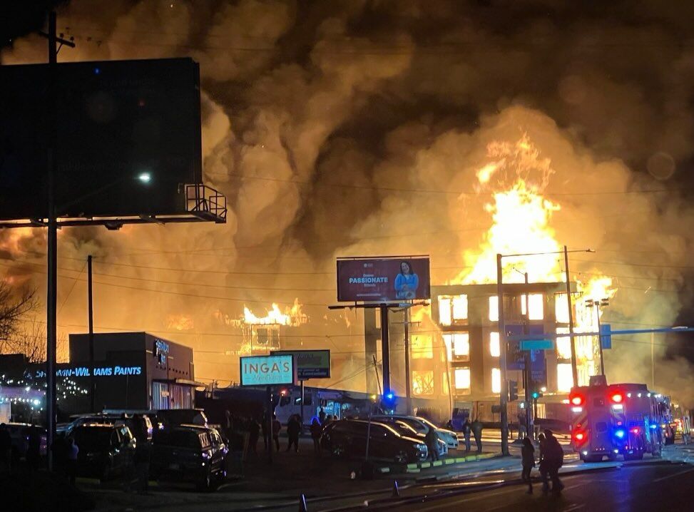
Man arrested for arson in connection with five-alarm Leetsdale fire
Michael Braithwaite
michael.braithwaite@gazette.com
Updated 1 hour ago
Authorities announced Wednesday the arrest of a man in connection with one of the largest fires Denver has seen in decades. Tony Becerra, 38, faces arson charges in relation to a five-alarm fire on Leetsdale Drive that burned and destroyed...
Michael Braithwaite
Reporter
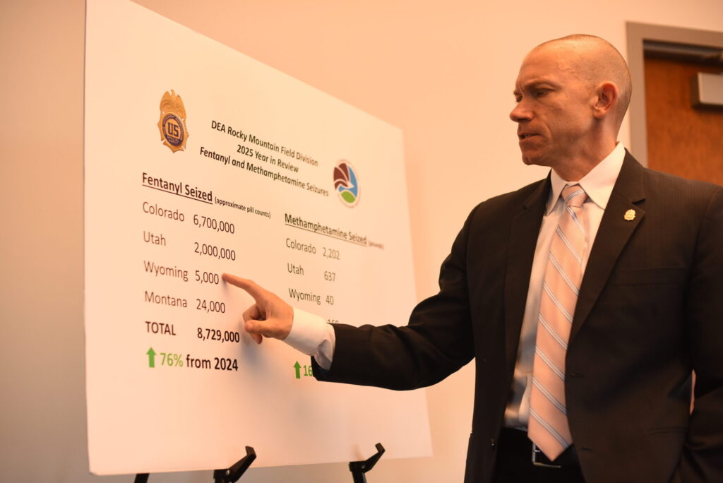
Rocky Mountain region saw record fentanyl pill, meth seizures in 2025, DEA says
Michael Braithwaite
michael.braithwaite@gazette.com
Updated 1 hour ago
The Rocky Mountain region saw record-breaking amounts of fentanyl pills and methamphetamines seized in 2025, officials with the U.S. Drug Enforcement Administration (DEA) said Wednesday. Throughout last year, Colorado saw a 76% increase in fentanyl pill seizures in comparison to...
Michael Braithwaite
Reporter
PREV
PREVIOUS

Jason Crow rips Pentagon probe into Mark Kelly over video urging troops to refuse 'illegal orders'
Democratic U.S. Rep. Jason Crow on Monday accused President Donald Trump of trying to incite violence and intimidate critics after the Pentagon announced an investigation into Arizona Sen. Mark Kelly’s participation in a video produced with Crow and other Democratic lawmakers that urged troops to refuse to carry out illegal orders. “You can’t bully a […]
Denver weather: Mild conditions Wednesday lead to 1-3" of snow over holiday weekend
Weather around metro Denver on Wednesday is forecast to be seasonal, with some sun some clouds but calm and quiet throughout the day. The city’s big change comes Friday night as a storm system is forecast to cool things down a lot and snow is possible each weekend day. Denver residents can expect mostly sunny […]