


Up to 24″ of snow could fall on some Colorado peaks over Thanksgiving weekend
As the incoming weather pattern continues to shift and evolve, it’s looking like a large portion of Colorado’s mountainous terrain could get hit pretty hard with snow over Thanksgiving weekend in what should turn out to be one of the most significant snowstorms of the season thus far.
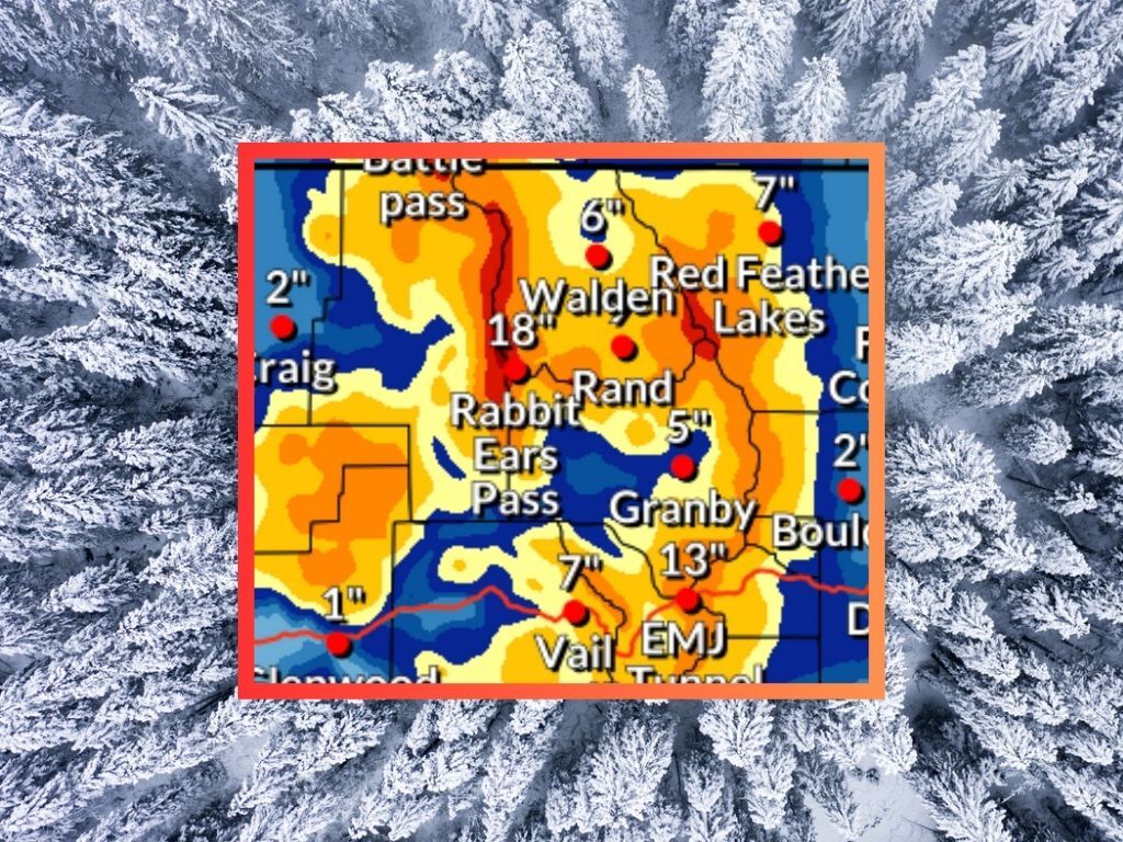
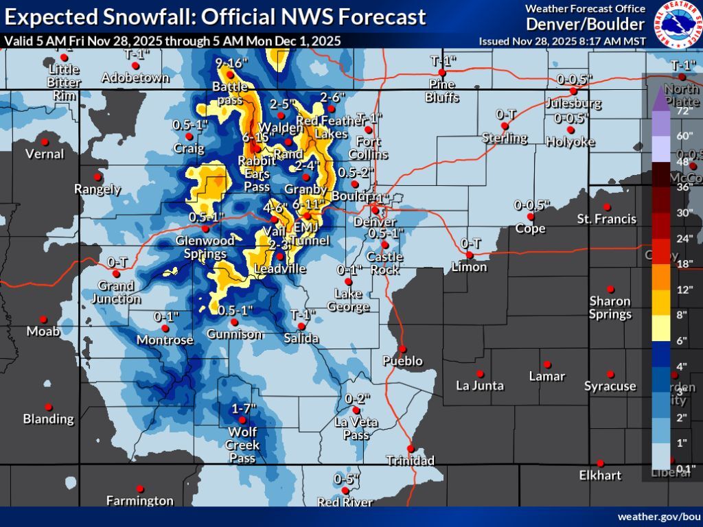
According to the National Weather Service, northern Colorado peaks should be favored in snow from Friday through Monday morning, opposed to prior predictions that showed the southwest having a higher chance of deeper accumulation. In both the ‘expected’ snowfall scenario with an 80% chance and in the ‘high-end’ snowfall scenario with a 10% chance, some peaks could get up to 24 inches of snow.
As far as the ‘expected’ scenario goes, many northern Colorado peaks could get between eight and 18 inches through Monday morning, with up to 24 possible in the Park Range near Steamboat Springs. The southwestern and southern peaks get much less, though there’s still a chance for up to seven inches on the oft-problematic Wolf Creek Pass. It’s also worth highlighting that in this mid-range ‘expected’ scenario, the I-70 stretch near the Eisenhower-Johnson tunnel complex could get up to 11 inches of snow – this could pose some serious issues for holiday weekend travelers.
See the ‘expected’ snowfall scenario below (and keep scrolling to see the ‘high-end’ snowfall scenario):
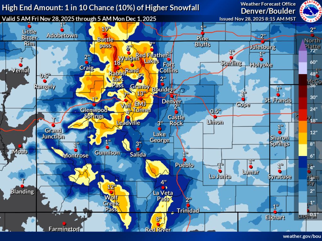
Holiday travelers will be even moreso impacted if the ‘high-end’ snowfall scenario hits, which ups accumulation totals quite a bit around the state. In this scenario, which is less likely but more impactful, most of the state’s peaks have a chance at getting at least 12 inches of snow, while a more widespread area in northern Colorado could get snow in that 12 to 24-inch range. Mountains around I-70 in the area of the Eisenhower-Johnson tunnel complex could get up to 18, with around 13 inches expected on the road.
In both scenarios, the Front Range metro areas are mostly missed. Those along the I-25 corridor shouldn’t expect more than a couple inches if that – at least through Monday morning.
As a result of the wintery weather that’s expected, a large swath of Colorado’s central and northern mountains are on a ‘winter weather advisory.’
While it’s looking like a good amount of snowfall is on the way, Colorado’s snow season remains relatively dry thus far – at just 36 percent of what’s normal for November 28.
Find additional forecasting information and details about related weather alerts on the National Weather Service website.
STAY INFORMED: Get free Colorado news with our daily newsletter (Click here)
Get OutThere
Signup today for free and be the first to get notified on new updates.
PREV
PREVIOUS

From a Thanksgiving Day brawl in 1899 to an NFL star's latest jab, a football rivalry lives on at Colorado's state line
Buffalo Bills quarterback Josh Allen is making headlines in Colorado this week after bashing Colorado State University during a jersey retirement ceremony that his alma mater hosted to honor his collegiate career. Granted, his alma mater happens to be the University of Wyoming – a bitter rival of the CSU Rams. Colorado State University Rams […]

Colorado man dead on island vacation after jealous suspect’s alleged mistaken-identity attack, police say
A tourist from Colorado was killed on the Caribbean island of Tobago on Wednesday night, ambushed on a dark walkway and left with a knife in his back. Local news source Trinidad and Tobago Newsday reports that the killing is believed to be the result of the suspect’s “jealous fit of rage” and a mistaken […]