


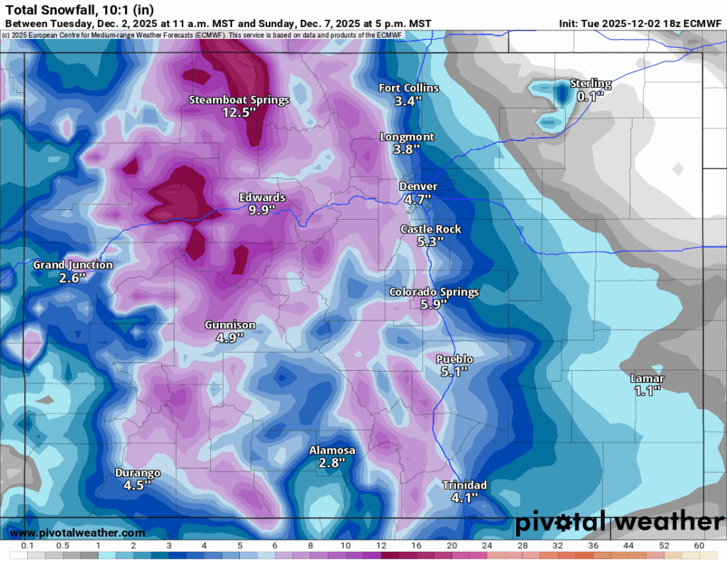
10-20″ of snow forecast in Colorado from multi-day weekend storm
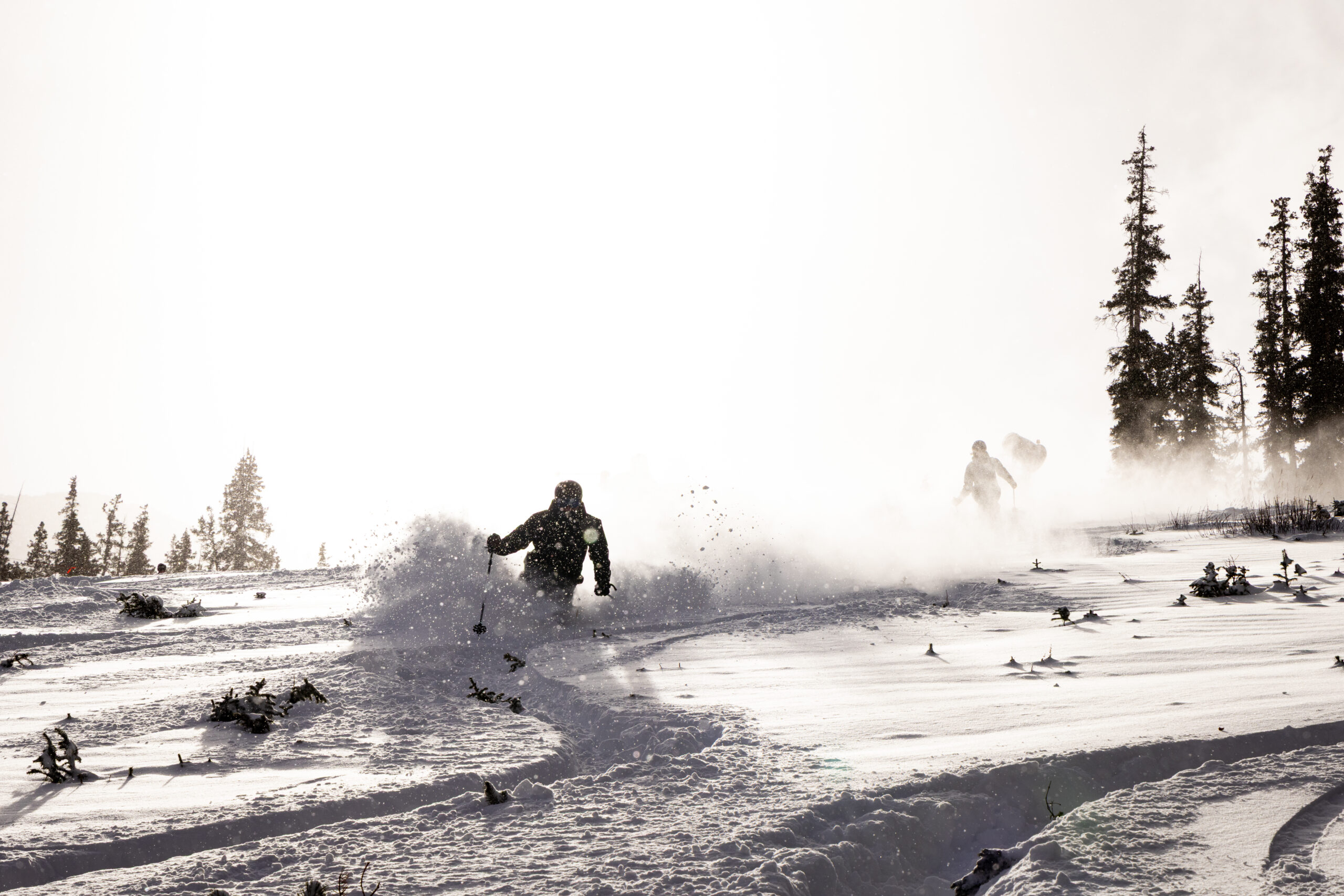
Winter weather continues to bring a lot more snow to Colorado’s high country in December as a multi-day weekend storm packs between 8-16″ for some ski areas across the state.
In all, 10-20″ of snow is possible by weekend’s end after a smaller storm deposits 4-8″ of snow mid week.
Colorado’s snowpack average gained some ground too, showing signs of straying away from previous well-below median average winters like 1999-2000.
Recap:
Monday was a powder day across much of the state, where anywhere between 3-12 inches fell. On Tuesday, a clouds-increasing kind of day was had as another storm approached from the northwest.
It was snowing lightly in the west central mountains most of the afternoon and evening, but shifted to the eastern side of the state after midnight.
Snow accumulations for Wednesday’s first chairs in all three mountain zones are between 2-6 inches.
Colorado’s Snowpack:
Colorado’s snowpack continues to recover after an awful November.
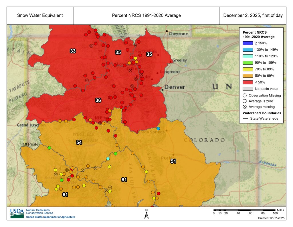
As of Dec. 2, the snowpack has clawed its way back above 40% of median average to 43% with 1.6 inches of snow water equivalent, which is still 2 inches below average locked away in the snow.
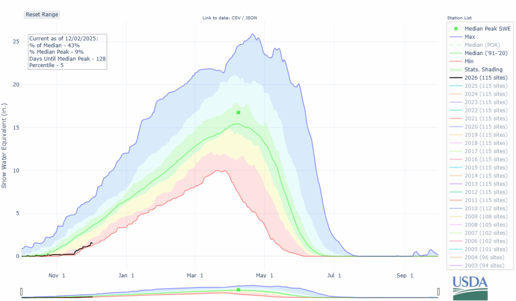
Winter 2025-26 was rivaling winter 2012-13’s and winter 1999-2000’s for the worst starts to a season since NRCS snowpack records began in winter 1986-87.
Northern Colorado’s snowpack in its four river basins has each basin at 36% of average or lower, where as in southern Colorado’s four river basins each basin is at 51% of average or greater.
Forecast:
Upslope winds are forecast to push good moisture levels into the Front Range Mountains throughout the day and for places like Echo, Eldora, Winter Park and Loveland/Arapahoe Basin, heavier snowfall totals can happen, but between 4-8 inches is most likely by Wednesday night.
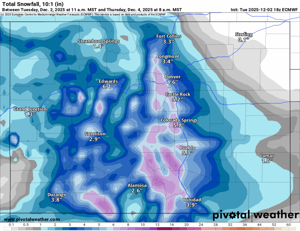
Due to the upslope nature of this storm, the southern mountains of the eastern San Juan, and Sangre de Cristo and Wet mountain ranges should see the highest totals; up to 10 inches in some spots.
Thursday’s forecast shows a calmer and dry day, however, another larger storm system fast approaching, this time from the northwest, comes in two waves (Friday into Saturday, then Saturday night into Sunday morning).
Friday is most likely a storm riding day, Saturday and Sunday are the powder days.
Additional snowfall totals by Sunday midday in the northern mountains are forecast to be between 3-16 inches, with amounts close to the 16-inch mark around Steamboat in the Park Range and in backcountry zones in the Flattops.
In the central mountains expect additional snowfall amounts to be between 3-7 inches with the highest totals in Pitkin County around Aspen/Snowmass and Sunlight, and in the southern mountains between 2-5 inches with the highest amounts in the northern San Juan Mountains near Silverton and Telluride.
Even if most ski areas and resorts have minimal terrain open, this storm should be ‘the one’ to help crews open more terrain heading into the second week of December.
Long-term forecast:
On Monday, light snow flurries could linger in the northern and eastern mountains as the storm exits eastward.
From Tuesday to Friday, Dec. 12, Colorado is forecast to mostly be between storms, bigger snow events anyway, as the jet stream keeps storm energy north of Colorado. However, some snow is possible Thursday, Dec. 11 and Friday, Dec. 12 in the northern mountains, but the central and southern mountains mostly stay dry.
Colorado ski resorts’ planned opening dates and 24-hour totals:
Arapahoe Basin – 2″
Aspen Highlands – Dec. 13
Aspen Mountain – 2″
Beaver Creek – 3″
Breckenridge – 2″
Buttermilk – Dec. 13
Cooper – Dec. 10
Copper Mountain – 3″
Crested Butte – 2″
Echo Mountain – Dec. 12
Eldora Mountain – 5″
Granby Ranch – 0″
Hesperus – Closed for the season
Howelsen Hill – Dec. 6
Kendall Mountain – December
Keystone – 2″
Loveland – 2″
Monarch – 1″
Powderhorn – Delayed, ASAP
Purgatory – 0″
Silverton – Private mountain after Dec. 1, Guided and Heli season Dec. 27
Snowmass – 2″
Steamboat – 2″
Sunlight – Dec. 12
Telluride – Dec. 6
Vail – 4″
Winter Park – 2″
Wolf Creek – 0″