


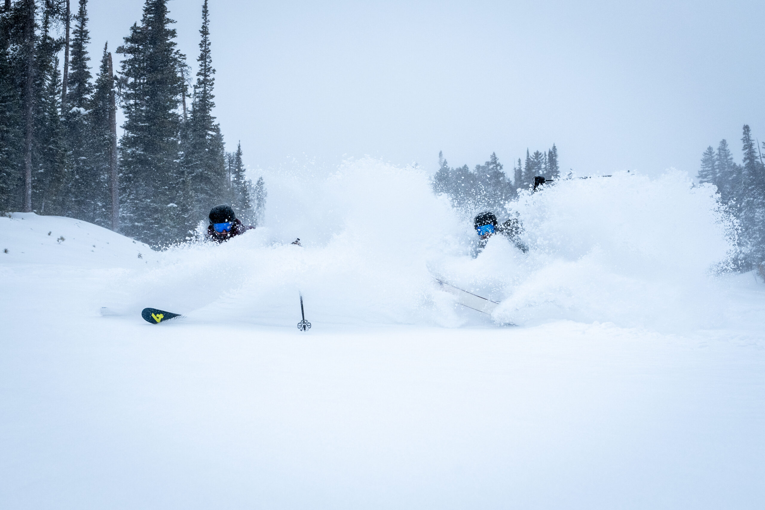
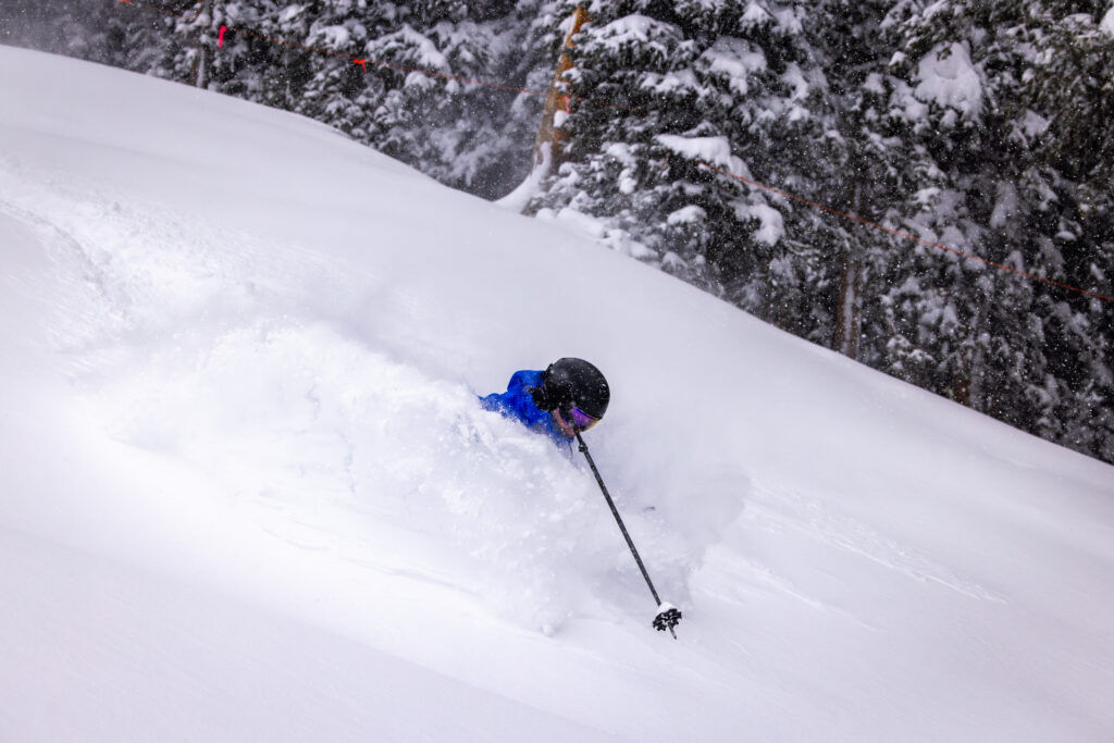
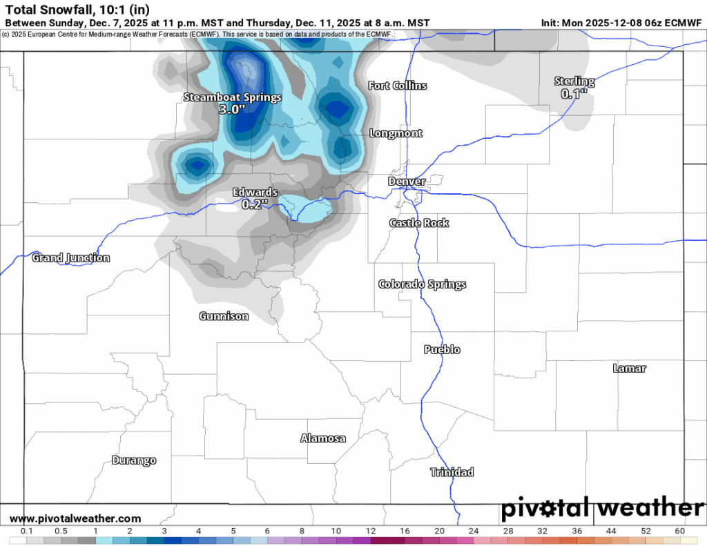
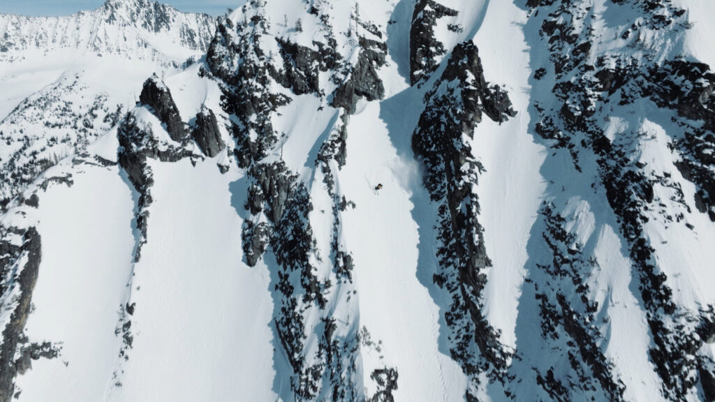
Large weekend storm drops 33″ of snow at one Colorado spot, snowpack doubles over 7 day stretch
The first big snow storm of winter 2025-26 for Colorado dropped about 10-20 inches in the northern mountains, 8-14 inches in the central mountains and 3-8 inches in the southern mountains.
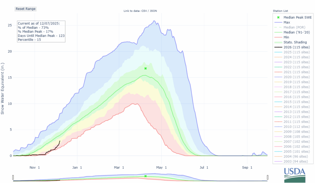
Colorado’s snowpack doubled in both median average and snow water equivalent values over the first seven days of December.
Some light snow is forecast for the northern mountains for the first half of the week, then a dry spell could settle in as mid-month starts.
Moment of Zen:
Recap:
From late Friday night to early Sunday morning, a slow moving area of low pressure pushed ample moisture into the state for 40 hours or so, dropping 10-20 inches of snow in the northern mountains, 6-12 inches in the central mountains and 3-8 inches for the southern mountains.
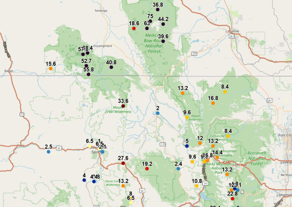
According to the National Weather Service, the SNOTEL site at Mount Zirkel north of Steamboat recorded 33.6 inches of snow over the weekend and went from 1.8 inches of snow water equivalent to 5.5 inches from Dec. 4 to Dec. 7.
Further north, in the Medicine Bow Range of Wyoming, the SNOTEL site at Medicine Bow Peak west of Centennial, WY recorded a whopping 75 inches of snow in 48 hours.
Colorado’s snowpack:
On Sunday, Nov. 30, Colorado’s snowpack was at 37% of median average, with 1.3 inches of snow water equivalent calculated.
After a snowy first week of December, that average ascended 36 percentage points to 73% of median average, with 2.9 inches of snow water equivalent locked away in the snowpack.
Forecast:
Light snow develops Monday for the northern mountains, with the highest amounts forecast around the Park Range near Steamboat.
Snowfall accumulations are forecast to be between 1-3 inches in the northern mountains, a trace-1 inch in the northern central mountains and little to no snow in the southern mountains.
Snow is forecast to develop again Tuesday night, lasting through Wednesday night, with an additional 1-2 inches in the northern mountain for Thursday morning’s first chairs, and little to no snow for the central and southern mountains.
Long-term forecast:
From Thursday to Sunday night Colorado will be between storms as the jet stream keeps any areas of low pressure and associated moisture north of the state.
On Sunday, a fast moving low pressure out of the southwest is forecasting to pass through Colorado into Monday morning. However, this low pressure lacks moisture and could be mostly produce a wind event on Sunday and Monday.
The next possible larger storm for Colorado’s high country could be as far out as Wednesday, Dec. 17 through Thursday, Dec. 18.
Colorado ski resorts’ planned opening dates and 24-hour totals:
Arapahoe Basin – 2″
Aspen Highlands – Dec. 13
Aspen Mountain – 0″
Beaver Creek – 0″
Breckenridge – 1″
Buttermilk – Dec. 13
Cooper – Dec. 10
Copper Mountain – 1″
Crested Butte – 0″
Echo Mountain – Dec. 12
Eldora Mountain – 2″
Granby Ranch – 0″
Hesperus – Closed for the season
Howelsen Hill – 1″
Kendall Mountain – Dec. 13
Keystone – 2″
Loveland – 1″
Monarch – 0″
Powderhorn – 0″
Purgatory – 0″
Silverton – Private mountain after Dec. 1, Guided and Heli season Dec. 27
Snowmass – 0″
Steamboat – 2″
Sunlight – Dec. 12
Telluride – 0″
Vail – 1″
Winter Park – 1″
Wolf Creek – 0″

Higher home values, abatements to push DPS tax bills up in 2025
Nico Brambila
nico-brambila@denvergazette.com
Updated 2 minutes ago
Denver homeowners will pay more in school taxes next year even though Denver Public Schools (DPS) slightly lowered its overall tax rate. The increase is being driven by rising assessed home values, a full 52.142-mill levy and a dramatic increase...
Nico Brambila
Reporter
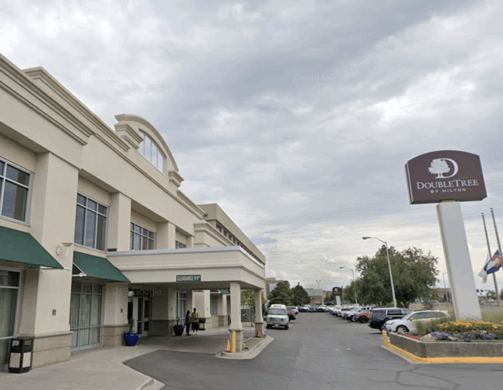
Denver approves $30M shelter contract with Urban Alchemy
Deborah Grigsby
deborah.smith@denvergazette.com
Updated 48 minutes ago
With a 9-4 vote, Denver City Council members approved a new $30 million, three-year contract with Urban Alchemy, a San Francisco-based nonprofit, to run The Aspen, a former DoubleTree Hotel that has been turned into a homeless shelter. More than...
Deborah Grigsby
Reporter
Nicole Harrison will give you the shirt on your back
John Moore
john.moore@denvergazette.com
Updated 4 minutes ago
2025 DENVER GAZETTE TRUE WEST AWARDS: DAY 9 Prolific costume designer had a hand in the making of 60 theatrical endeavors in 2025, surely the most of anyone in Colorado I’m pretty sure I first met Nikki Harrison in 1995...
John Moore
Reporter
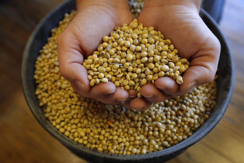
Trump administration announces $12 billion soybean aid package
RACHAEL WRIGHT Special to The Gazette
rachael-wright-special-to-the-gazette@denvergazette.com
Updated 2 hours ago
President Donald Trump and Secretary of Agriculture Brooke Rollins announced Monday that the administration was planning to disburse a $12 billion dollar aid package as part of the Farmer Bridge Assistance (FBA) Program, to make targeted, one-time payments to crop...

Adams County officials call for resignation of county treasurer after ‘inappropriate behavior’
9News
9news@denvergazette.com
Updated 3 hours ago
Adams County Commissioners requested the resignation of the county’s treasurer after multiple allegations of inappropriate behavior toward staff members, but he has declined to step down. An independent investigation found multiple allegations against County Treasurer Alex Villagran to be credible,...
9News
Reporter

Warm up with cocoa, champurrado, and atole recommended by Denver foodies
Emily Bejarano
emily-bejarano@gazette.com
Updated 46 minutes ago
Not a coffee drinker? Sip your way to happiness with these hot cups of chocolatey, corny goodness On a snowy day in Denver, nothing hits the spot quite like a warm cup of cocoa – that is, if you’re not...
Emily Bejarano
Reporter
Denver explores moving city to biennial budget
Deborah Grigsby
deborah.smith@denvergazette.com
Updated 3 hours ago
The Denver City Council is considering moving the city to a two-year budget cycle, with the option to revert to a one-year cycle during “economic uncertainty.” The proposed measure, put forth during Monday’s Budget and Policy Committee meeting, aims to...
Deborah Grigsby
Reporter

Lakewood police still investigating burglary turned homicide
Sage Kelley
sage-kelley@denvergazette.com
Updated 3 hours ago
The Lakewood Police Department is investigating an alleged burglary that ended in a homicide Saturday evening. Police responded to 300 S. Kendall St. — in a cul-de-sac next to West Alameda Avenue — Saturday evening after someone reported that a...
Sage Kelley
Reporter
Ski film “Inaccessible” premieres in Boulder, looks at public land access from a skier’s perspective
Jonathan Ingraham
jonathan.ingraham@denvergazette.com
Updated 3 hours ago
There are approximately 640 million acres of public land in the United States but roughly 16 million acres of that land is ‘landlocked’ by private owners, making the land inaccessible. Knowing how to access these public lands is another challenge....
Jonathan Ingraham
Reporter

Metro Denver gas prices drop to some of the lowest in the nation this holiday season
Noah Festenstein
noah-festenstein@denvergazette.com
Updated 2 hours ago
Metro Denver motorists are saving more money on gas compared to other major cities nationwide this holiday season. One oil pricing expert said some Denver gas stations are some of the cheapest not only in Colorado, but across the country....
Noah Festenstein
Reporter
PREV
PREVIOUS
Denver weather: More melting on Monday as temperatures climb
Melting snow will continue Monday across metro Denver as the sun is forecast to come out in full as temperatures push into the 50s today. Denverites can expect sunny skies, with a high near 53 today, according to the National Weather Service in Boulder. South winds around 8 mph become west northwest in the afternoon. […]

Colorado Democrat Julie Gonzales launches U.S. Senate primary challenge to incumbent John Hickenlooper
Declaring that Colorado “needs a fighter, not a bystander,” state Sen. Julie Gonzales, a Denver Democrat, on Monday launched her long-anticipated primary challenge to U.S. Sen. John Hickenlooper. Pitching her campaign as a departure from “old-playbook politics,” Gonzales said she’s appealing to voters who are “sick and tired of Democrats trying to manage primaries from […]