


90 mph wind gusts, snow forecast for Colorado as wild weather swings continue
Windy conditions in Colorado’s high country are forecast for Wednesday ahead of light snow Thursday as December’s wild weather continues.
A larger storm for the weekend will add snow to the northern and central mountains mainly.
A few-days lull in storminess is forecast ahead of Christmas, however, a broader reaching storm is on the horizon to begin Christmas Day, bringing more snow to all three mountain zones.
Recap:
More wind was experienced in the Front Range foothills, especially on Tuesday, where a wind gust of 72 mph was recorded at Niwot Ridge near Eldora Mountain Resort in Boulder, County.
Downsloping winds on the east side of the Continental Divide provided warm conditions at some ski areas, but the warm air stayed in the east too. Eldora’s high temperature on Tuesday was 37 degrees, whereas Keystone’s was 25 degrees.
Forecast:
A very windy day is forecast on Wednesday and Wednesday night for the Front Range Mountains from the Wyoming/Colorado state line to Colorado Springs in the north and in the Wet and Sangre de Cristo mountains from Pueblo to the Colorado/New Mexico state line in the south.
Westerly winds of between 30-50 mph with gusts up to 90 mph are expected.
Windy conditions are also forecast in the Sawatch Mountains in central Colorado and the Rabbit Ears Range north of Kremmling and Park Range near Steamboat in north-central Colorado.
Late Wednesday morning snow is forecast to develop in the northern mountains along with the wind.
Snow will end overnight Thursday, providing a light powder day and snowfall totals of between 3-6 inches in the northern mountains with the highest amounts in the Park Range, in the central mountains between 1-6 inches with the highest amounts north of Glenwood Springs and in the southern mountains between a trace-1 inch with any snowfall recorded in the northern San Juan Mountains near Silverton.
Wind transport of snow from west facing slopes to east facing slopes will load up avalanche prone areas. It is possible the Colorado Avalanche Information Center issues an avalanche alert for backcountry travelers starting Thursday morning on certain aspects, even with current low snow accumulations.
Similar to prior forecasts, light snow is trending toward redeveloping Thursday night through Friday morning in the northern mountains where an additional 1-2 inches could fall for Friday’s first chairs.
On Friday night, one more shot of storm energy pushes through Colorado and is forecast to bring more snow through Saturday evening.
This wave is still focused on northern and central Colorado primarily, with an additional 4-6 inches possible in the northern mountains with the highest amounts once again around Steamboat, in the central mountains between 2-3 inches with the highest amounts in the northern Sawatch Mountains and north and south of Glenwood Springs, and in the southern mountains between 1-2 inches nearly all in the northern San Juan Mountains.
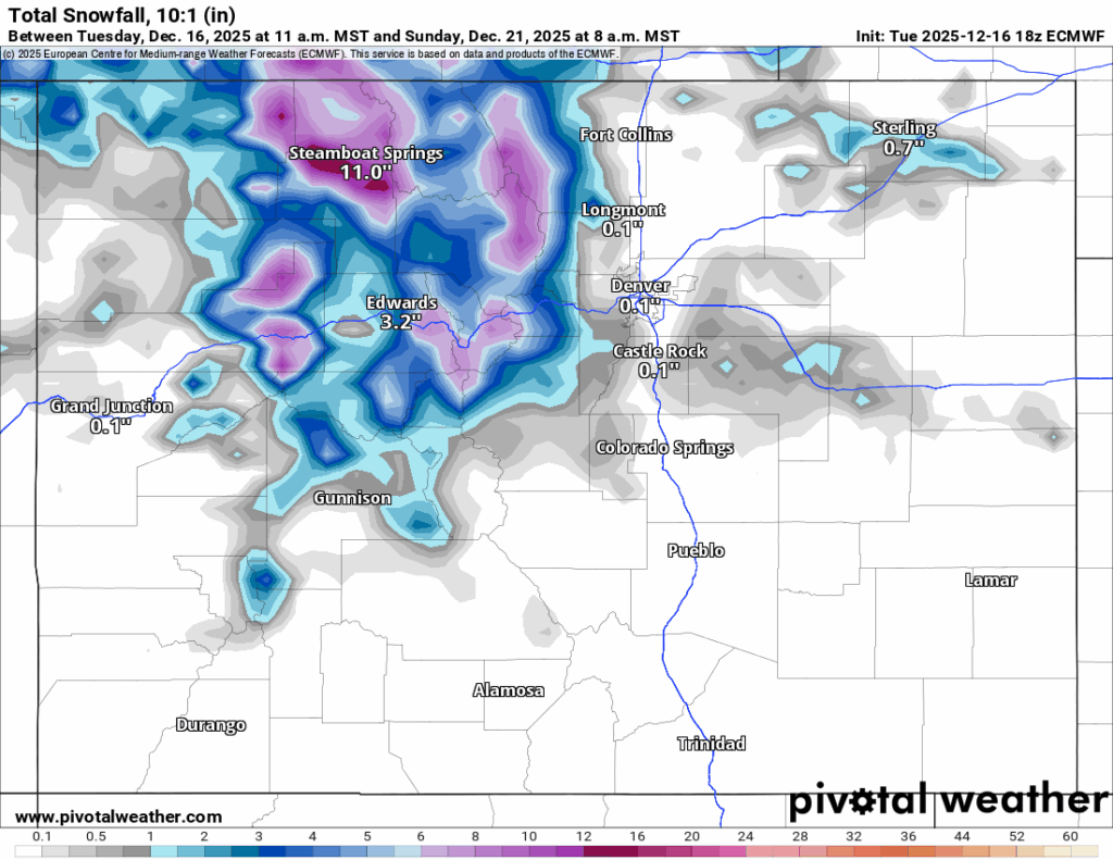
Sunday’s skiing and riding is forecast to be calmer around Colorado heading into the start of the Christmas week, however, a short wave of storminess could bring light snow Sunday night to extreme northern Colorado.
Long-term forecast:
From Monday to Wednesday, Christmas Eve Colorado is forecast to be dry yet windy again ahead of a potential storm from overnight Thursday, Dec. 25 Christmas Day to late Friday, Dec. 26 morning.
This storm is still forecasting to bring some snow to the southern mountains, more than the previous two, but after 48 hours of additional model runs, the renderings have the majority of the snow falling by Friday, Dec. 26 evening in the west-central and northern mountains primarily.

One more storm wave is possible to start Sunday, Dec. 28 evening and last through Monday, Dec. 29 early afternoon.
Colorado ski resorts 24-hour totals:
Arapahoe Basin – 0″
Aspen Highlands – 0″
Aspen Mountain – 0″
Beaver Creek – 0″
Breckenridge – 0″
Buttermilk – 0″
Cooper – 0″
Copper Mountain – 0″
Crested Butte – 0″
Cuchara – 0″
Echo Mountain – 0″
Eldora Mountain – 0″
Granby Ranch – 0″
Hesperus – Closed for the season
Howelsen Hill – 0″
Kendall Mountain – 0″
Keystone – 0″
Loveland – 0″
Monarch – 0″
Powderhorn – 0″
Purgatory – 0″
Silverton – Guided & Heli season Dec. 27
Snowmass – 0″
Steamboat – 0″
Sunlight – 0″
Telluride – 0″
Vail – 0″
Winter Park – 0″
Wolf Creek – 0″

State audit: Rape kit backlog reduced but more work needed to hit goal
Jenny Deam
jenny-deam@denvergazette.com
Updated 2 minutes ago
In the past year the Colorado Bureau of Investigation has slashed the time it takes to process DNA collected in sexual assault cases, but the agency still is far short of its turnaround goal, the state auditor reported on Wednesday....
Jenny Deam
Reporter

Aurora officials look to Fort Worth in creation of police oversight office
Kyla Pearce
kyla-pearce@denvergazette.com
Updated 34 minutes ago
As Aurora officials continue the process of creating a police oversight office, the police monitor of a Texas city similar to Aurora in size, demographics and structure told officials and residents Tuesday night that her office has built a strong...
Kyla Pearce
Reporter

Greeley voters halt landmark development project
Hap Fry, Special to The Gazette
hap-fry@gazette.com
Updated 1 hour ago
GREELEY – The landscape-altering Cascadia development project has been put on ice, according to unofficial results of a city referendum on the project Tuesday. The proposed Cascadia amenities included an 8,600-seat multiuse arena and ice center that would be the...
Hap Fry, Special to The Gazette
Reporter
Polis administration awards $7.2 million to cut emissions from large buildings
Scott Weiser
scott-weiser@denvergazette.com
Updated 1 hour ago
The Colorado Energy Office awarded $7.2 million Wednesday to help owners of large buildings across the state pursue high-impact projects that reduce greenhouse gas emissions through improved energy efficiency and electrification. The grants, drawn from federal Climate Pollution Reduction Grant...
Scott Weiser
Reporter

Denver Police arrest man, 20, in fatal Maple Avenue house party fight, shooting
Michael Braithwaite
michael.braithwaite@gazette.com
Updated 40 minutes ago
Denver Police Department announced an arrest Tuesday in connection with a shooting a few weeks prior, during which one person was killed and another injured. Yeanbraiker Yriarte-Valera, 20, faces a first-degree murder charge after he allegedly shot and killed a...
Michael Braithwaite
Reporter
Report: Palantir exit could deal $178M blow to Colorado economy
Bernadette Berdychowski
bernadette.berdychowski@denvergazette.com
Updated 2 hours ago
Palantir Technologies’s decision to move its headquarters from Colorado to Florida is raising fresh concerns about the state’s business climate, with a new report warning the departure could shave hundreds of millions of dollars from Colorado’s economy and signal broader...
Bernadette Berdychowski
Reporter

Report: Palantir exit could deal $178M blow to Colorado economy
Bernadette Berdychowski
bernadette.berdychowski@denvergazette.com
Updated 1 hour ago
Palantir Technologies’ decision to move its headquarters from Colorado to Florida is raising fresh concerns about the state’s business climate, with a new report warning the departure could shave hundreds of millions of dollars from Colorado’s economy and signal broader...
Bernadette Berdychowski
Reporter

New Arvada Center CEO is Zoo’s Noelle DeLage
The Denver Gazette
the-denver-gazette@denvergazette.com
Updated 2 hours ago
The Arvada Center has named Noelle DeLage, chief communications and philanthropy officer of the Denver Zoo Conservation Alliance, as its next president & CEO. DeLage succeeds the retiring Philip Sneed effective July 1, just as the Arvada Center begins its...
The Denver Gazette
Reporter

House Ethics Committee dismisses some claims, advances others against Rep. Ron Weinberg
Marianne Goodland
marianne-goodland@denvergazette.com
Updated 1 hour ago
The House Ethics Committee voted on Wednesday to accept three allegations filed against Rep. Ron Weinberg, R-Loveland, but combined two into one subject area. The two issues involve inappropriate comments made to female lawmakers in two separate incidents and the...
Marianne Goodland
Reporter
Bipartisan opposition sinks eviction bill in Colorado
Marissa Ventrelli
marissa-ventrelli@denvergazette.com
Updated 2 hours ago
Two Democrats sided with Republicans on the House Judiciary Committee to kill a bill that would have made several changes to eviction filings and proceedings, including requiring judges to suppress court records. Sponsored by Rep. Junie Joseph, D-Boulder, House Bill...
Marissa Ventrelli
Reporter
PREV
PREVIOUS

Denver weather: Breezy in town, high wind warning in effect for western foothills
A high wind warning goes into effect at 11 a.m., Wednesday for most of the western suburbs and foothills of metro Denver, with gusts ranging from between 65-85 mph. Denver residents can expect mostly sunny skies today, with a high near 69, according to the National Weather Service in Boulder. Breezy conditions will exist, with […]

U.S. House votes along party lines to begin debate on delisting gray wolves
The U.S. House on Tuesday voted along party lines on a resolution that will start the process for approval of legislation to delist gray wolves from the Endangered Species Act. The resolution sets up the rules for debate for six bills, including H.R. 845, which requires the Interior secretary “to reissue regulations removing the gray […]