


20-plus inches of snow: Timeline of when two waves are expected to hit Colorado
Two notable waves of snow are set to hit Colorado in upcoming days, bringing much-needed snow to the mountains. The Pivotal Weather forecast indicates that this snow could bring double-digits to much of the state’s mountainous terrain during a mid-February weather shake-up.
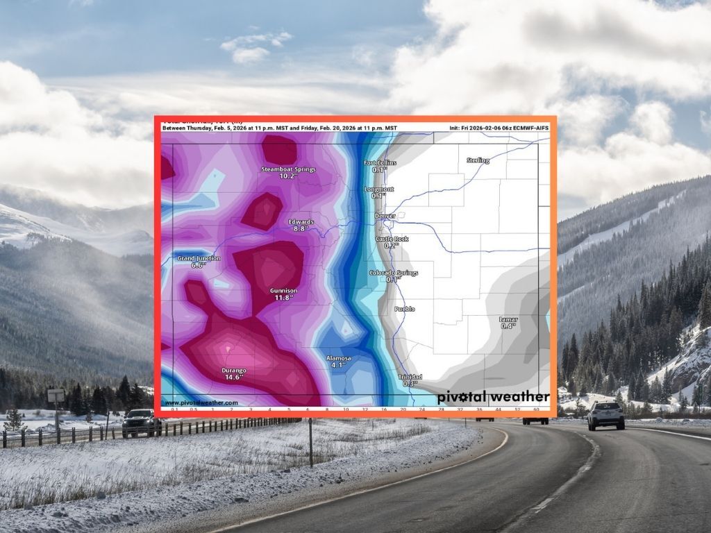
A first wave of snow should start on February 10, creeping south from Northern Colorado to eventually drop about eight inches of snow on peaks in the Aspen area, with the Flat Tops, the Park Range (near Steamboat Springs), and San Juan peaks north of Durango expected to get about seven inches. During this period, snow on the Front Range should be minimal.

A second wave of snow, however, should start on the night of February 15 with on-and-off snowfall in the mountains continuing into February 21. This wave of snow should result in an additional 10 inches of snow on Aspen-area peaks and the Flat Tops, with about six additional inches of snow dropped in the Park Range near Steamboat. Most notable, however, will be the 17 inches of snow this wave could bring to the San Juan peaks north of Durango, bringing the accumulation total for this part of the state to 24 inches between now and February 21.

Both waves of snow should skip Colorado’s most populated areas along I-25, resulting in minimal impacts in this part of the state.
Prior to this incoming snow, not much else is expected. OpenSnow is calling for about an inch at many ski areas over the next five days, but not more than that.
It’s worth noting that this incoming snow, while noteworthy, is still unlikely to put the state on par with February norms. Statewide snowpack is currently at just 55 percent of what’s typical for February 6, setting a new record for all-time low snowpack for the given date for the 25th day in a row.
STAY INFORMED: Get free Colorado news with our daily newsletter (Click here)
Get OutThere
Signup today for free and be the first to get notified on new updates.
PREV
PREVIOUS

Colorado's 'best diner' started in 1927 and serves close to 8,000 patrons each weekend
There’s something comforting about a great meal at a classic American diner, and according to Business Insider, Colorado’s best-of-the-best diner is located in Denver. A piece published by Business Insider on February 4 sought to highlight which diner was the best in each American state. When it came to Colorado, the top pick was Sam’s […]

New Denver restaurant highlights the best of Italy's Emilia-Romagna region
Denver foodies are abuzz about a new addition to the Mile High cuisine scene, brought to the city by the same team that’s behind Michelin-recommended and James Beard-nominated Restaurant Olivia. Now open for business, the recently opened Dear Emilia restaurant has a menu that’s inspired by northern Italy’s Emilia-Romagna region. Described as the “agricultural heart” […]