


30″ of snow hits some Colorado peaks with another 30″ expected
Over the last three days, big snow has fallen in several key parts of Colorado’s ski country, including about 30 inches on some select peaks in the Aspen area and between 18 and 24 inches on peaks near Steamboat Springs. Outside of areas that saw exceptional snowfall, totals of about six to 12 inches were widespread, with most of the state’s ski areas getting decent snow. That’s good news and all, but the even better news is what lies ahead.
Before digging into that, here’s a look at what snow fell over the last 72 hours (reds indicate 18-plus inches, with the deepest red being 30):

While the upcoming weekend should be relatively dry, snowfall should start ramping up again come February 16 with on-and-off snowfall expected through February 22. By that point, the Aspen area should have another 17 inches of snow, per the Pivotal Weather report, with peaks in southwest Colorado likely to have accumulated an additional 24-plus inches. Plus, days later, another wave of snow will be on the way.
Here’s a look at snowfall expected through February 22:

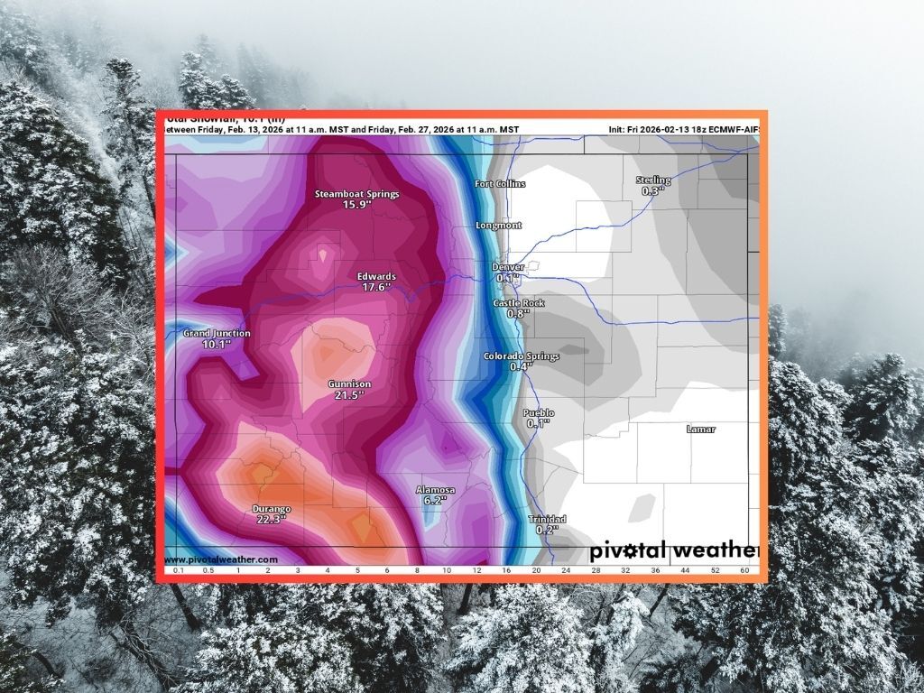
Come February 25, widespread snow is expected to start up again, adding about 14 additional inches in the Aspen area over the next couple of days. Some peaks in the San Juan region will also get hit hard, getting a total of up to 40 inches between now and February 27.
Here’s a look at expected snowfall between February 13 and February 27:

Throughout the month of February, the Aspen area should benefit the most, with the 31 inches expected now through the end of the month packing on top of the 30 inches that came with the most recent storm for more than 60 inches of snow over a stretch of about 18 days.
All of this snow will most definitely help Colorado’s snowpack situation and with the recent storm hitting a bit harder than expected and an intensification of the storms expected to hit later this month, it’s now very possible that Colorado exits the month above record low snowpack.
Colorado is currently at about 55 percent of the norm in terms of snowpack for February 13, with a snow-water equivalent jump of half an inch since February 10. This brings the snow-water equivalent to 5.9 inches below a norm of 6.8. The norm for the end of February is eight inches of snow-water equivalent.
Find additional forecasting information on the National Weather Service website.
STAY INFORMED: Get free Colorado news with our daily newsletter (Click here)
Get OutThere
Signup today for free and be the first to get notified on new updates.
PREV
PREVIOUS

Iconic Colorado marina won't open boat ramp for 2026 summer season due to dry winter
The notably dry winter that’s been underway in Colorado is already having an impact on summer recreation. Per a February 10 announcement from the Town of Frisco, current data and projections have resulted in the decision to close the Frisco Bay Marina boat ramp for 2026, also meaning that the spot’s 160 dock slips won’t […]

7 snowy hot spring soaks to sneak in before spring hits
Whether you’re looking to soothe tired muscles after a long ski day or simply looking for a relaxing winter activity, a soak in a hot springs is an excellent choice. Colorado has a variety of hot springs that offer everything from stunning mountain views and settings of snowy forests to a mix of riverside pools. […]