


Up to 23″ of snow could land on some Colorado peaks over three waves in upcoming days
A few days ago, potential snow to close out the month of March continuing into the first days of April made headlines. Now a bit closer to those dates, here’s what the updated forecast is saying:
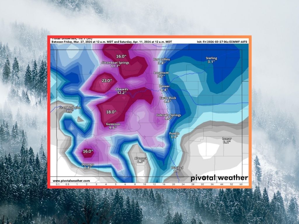
Per Pivotal Weather mapping, three waves of snow could hit Colorado over upcoming days. Given that warmer temperatures have been present around the state and that snowpack has been dropping off rapidly, don’t expect these storms to help out too much in terms of snowpack, but know that big snow could still fall.
On the high-end, mapping from Pivotal Weather shows that these three waves could bring about 23 inches of snow to the Flat Tops through April 11. Meanwhile, about 16 inches could land in the Park Range near Steamboat Springs and about 17 inches could land on peaks near Aspen. Southwest Colorado could see about 16 inches on some San Juan peaks – remember though, all of this snow would be stretched out between the three waves with drier conditions in between.

A first wave could hit between March 31 and April 2, followed closely by a second wave of snow that is predicted to start late on April 2 and continue until April 4. A third wave could then move through between April 8 and April 11.
Impacts for most Coloradans should be relatively minimal – even in the higher-end scenario, the Front Range metro corridor gets about four inches across the three storms.
In a lower-end projection from Pivotal Weather, the Flat Tops still gets about 18 inches across the storms with the Park Range getting about 15 inches. That said, deeper totals would be mostly restricted to northern Colorado.

While some springtime snow will be exciting on a record-setting year of winter dryness, it’ll likely to be too little, too late. Colorado’s statewide snowpack has melted substantially in recent days, at about 30 percent of what’s typical for this point of the season and at a level not typically seen until late-April, according to the USDA. Snowpack peaked at about 8.5 inches of snow-water equivalent on March 8 this year, already having dropped to 4.5 inches by March 27. The norm for March 27 is 14.7 inches and a normal peak is 16.8 inches of snow-water equivalent, typically around April 8.
Explore more mapping from Pivotal Weather here.
STAY INFORMED: Get free Colorado news with our daily newsletter (Click here)
Get OutThere
Signup today for free and be the first to get notified on new updates.
PREV
PREVIOUS

Winter Park announces popular Mary Jane area set to close 7 weeks ahead of last year
While recent years have allowed the Mary Jane area to stay open past the closing of the majority of Winter Park Resort’s skiing and snowboarding terrain, that won’t be the case this year. According to Winter Park Resort, the Mary Jane area was closed at noon on March 27 to preserve conditions for a final […]

Police arrest suspect who allegedly started a string of fires last year
The Colorado Springs Police Department has arrested a man who allegedly set a string of fires in October and November 2025 in Colorado Springs. According to reporting form KOAA News 5, Michael Lopez, 24, was identified as a possible suspect in starting two dumpster fires, one on October 25 and the other in November 2025, […]