




NWS map calls for up to 13″ of snow in Boulder, seven in Denver, and much more in mountains
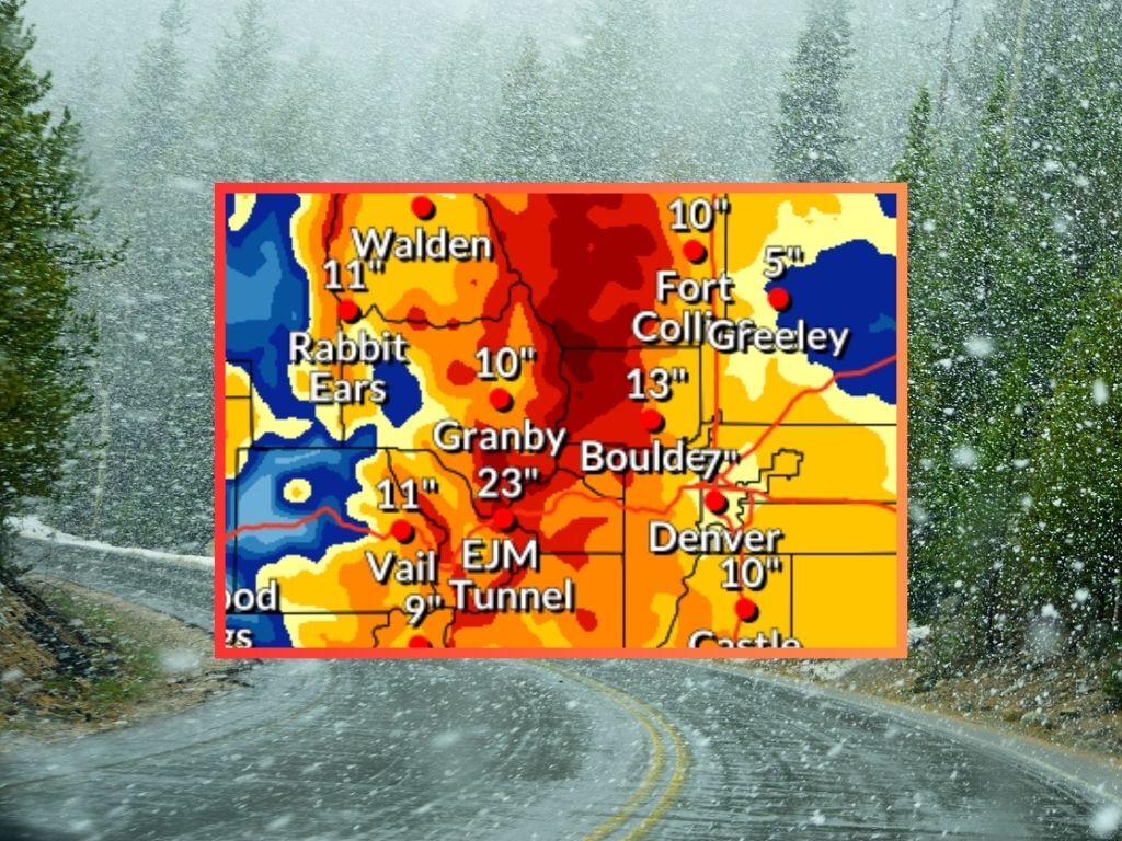
A day into a snowstorm that’s set to stretch into Wednesday, updated mapping from the National Weather Service shows that big snowfall is still on the way. Tuesday night will be particularly snowy, with the potential for Wednesday morning commutes to be impacted in the Denver metro area and beyond.
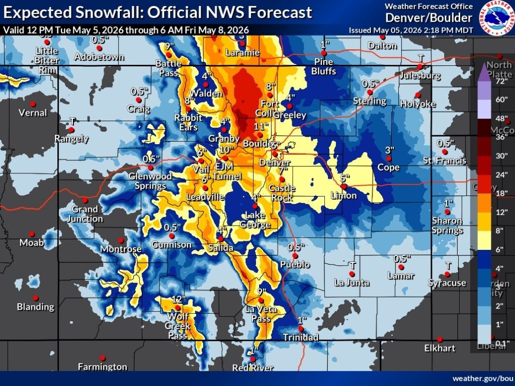
In the most likely ‘expected’ snowfall scenario (80% chance), the heaviest snowfall lands in the area of the Continental Divide north of I-70. This area could see about 18 to 30 inches of additional snow through Friday morning. The highest stretches of the Sangre de Cristos could see snowfall in the range 18 to 24 inches, as well. As far as mountain travel is concerned, the I-70 corridor in the area of the Eisenhower tunnel would be getting about 10 inches of snow in this scenario – though there’s a major uptick in that number if the ‘high-end’ scenario occurs (more on that below).
Outside of the aforementioned areas, many other high elevation peaks should get snow in the range of eight to 18 inches in the most likely scenario. Notably, Boulder could get 11 inches through Friday morning, with downtown Denver looking at about six – but keep in mind, this is the ‘expected’ snowfall scenario… the ‘high-end’ 10-percent chance scenario would mean more.
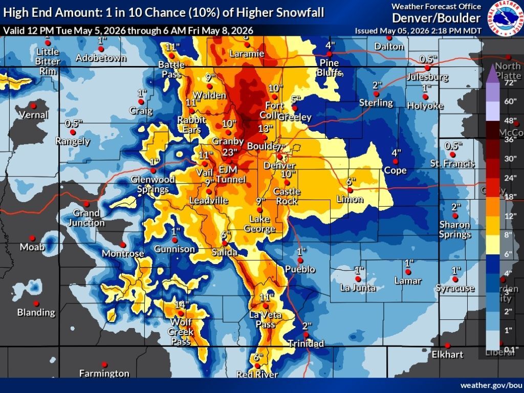
In the high-end scenario, the area around Longs Peak has a shot at 30 to 36 inches through Friday morning, with totals in the range of 18 to 30 inches more widespread around other northern peaks. This ‘high-end’ scenario would also mean about 13 inches of snow in Boulder, 10 in Fort Collins and Castle Rock, and about seven in Denver. While Colorado Springs would be looking at about three inches in the ‘expected’ scenario, this scenario would mean about five. It’s also worth noting that this scenario would bring about 23 inches to the I-70 corridor in the area of the Eisenhower tunnel.
See both snowfall scenarios depicted on the maps below, starting with the ‘expected’ and more likely scenario and then the ‘high-end’ scenario:
Colorado’s snowpack is at 19 percent of the norm for the date – a hair below the all-time record low. It’s likely Colorado will soon move above the record low snowpack level with the inbound snow.
Find additional forecasting information here.
STAY INFORMED: Get free Colorado news with our daily newsletter (Click here)
Get OutThere
Signup today for free and be the first to get notified on new updates.
PREV
PREVIOUS
Guide to visiting Georgetown: Find 'Wild West' vibes, countless trails, a train ride, and more
Although it’s a lesser known town in Colorado that people tend to pass by before heading farther west, Georgetown has a rich history in mining and offers a vibrant Wild West vibe. Located along the Interstate 70 mountain corridor, the mountain town offers a fascinating opportunity to learn about old mining history and culture, as […]
SNOW TOTALS: 28" of snow hits mountain town, big totals elsewhere around Colorado
As was expected, big snow hit Colorado this week. While Colorado Springs escaped this one without much of an impact, the Denver metro area and northern Colorado got hit hard. UPDATE: This piece has been updated on Thursday, May 7 to reflect updated snow totals with new locations added, as well. Following this week’s snow, […]