




Two waves of snow could bring 12-plus inches to some parts of Colorado
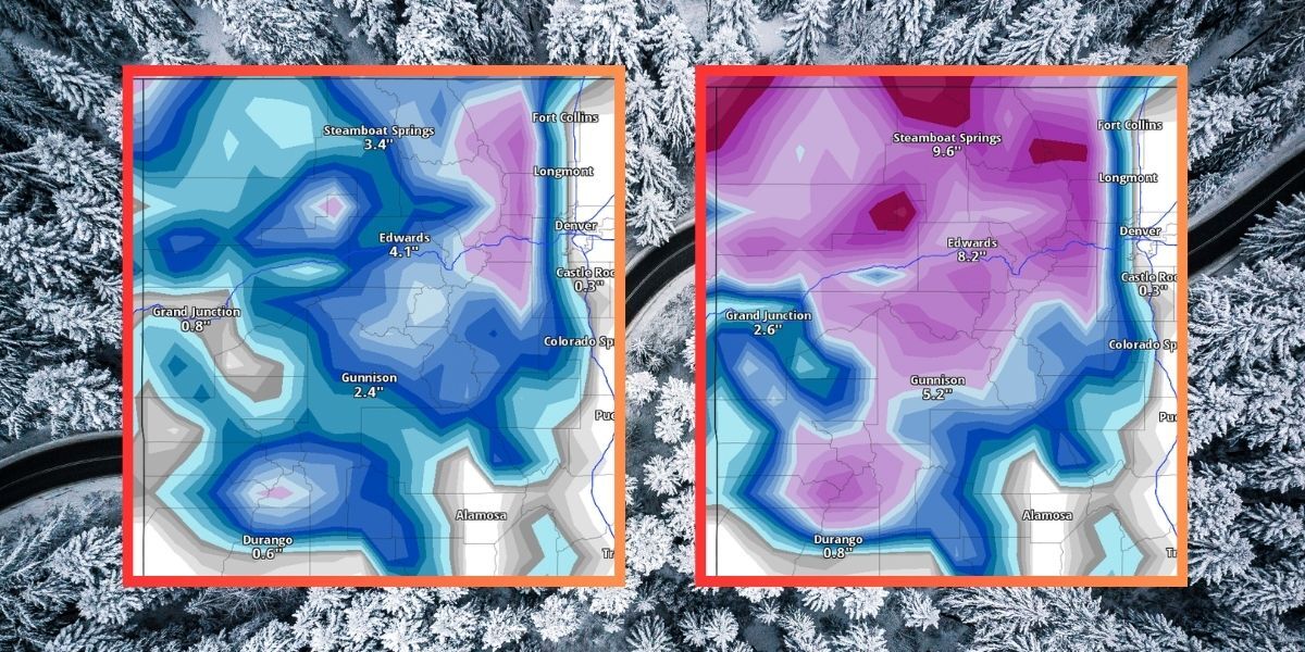
Despite the record-setting dryness of the winter season, it looks like the trend of springtime moisture is set to continue in Colorado – and the state might even get a bit more snow.
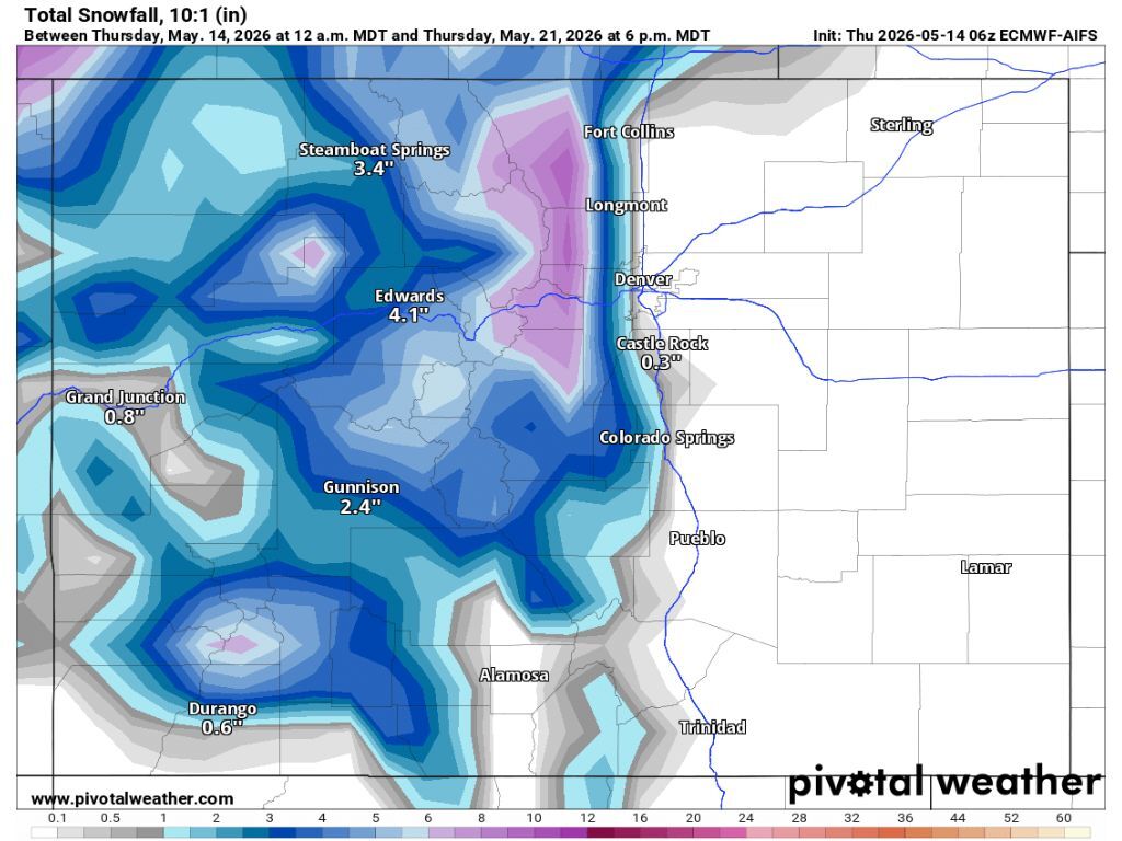
Per mapping published by Pivotal Weather, snow flurries could start to hit some of the state’s peaks on Sunday, May 17, with this snowfall ramping up on May 18 and continuing through May 21. The heaviest hit area in this scenario would be the Continental Divide north of I-70, seeing up to 10 inches of snow. That said, accumulation would be relatively widespread, landing on most of the state’s mountains in the range of four to seven inches. The I-25 corridor would be mostly skipped with the exception of flurries in Castle Rock.
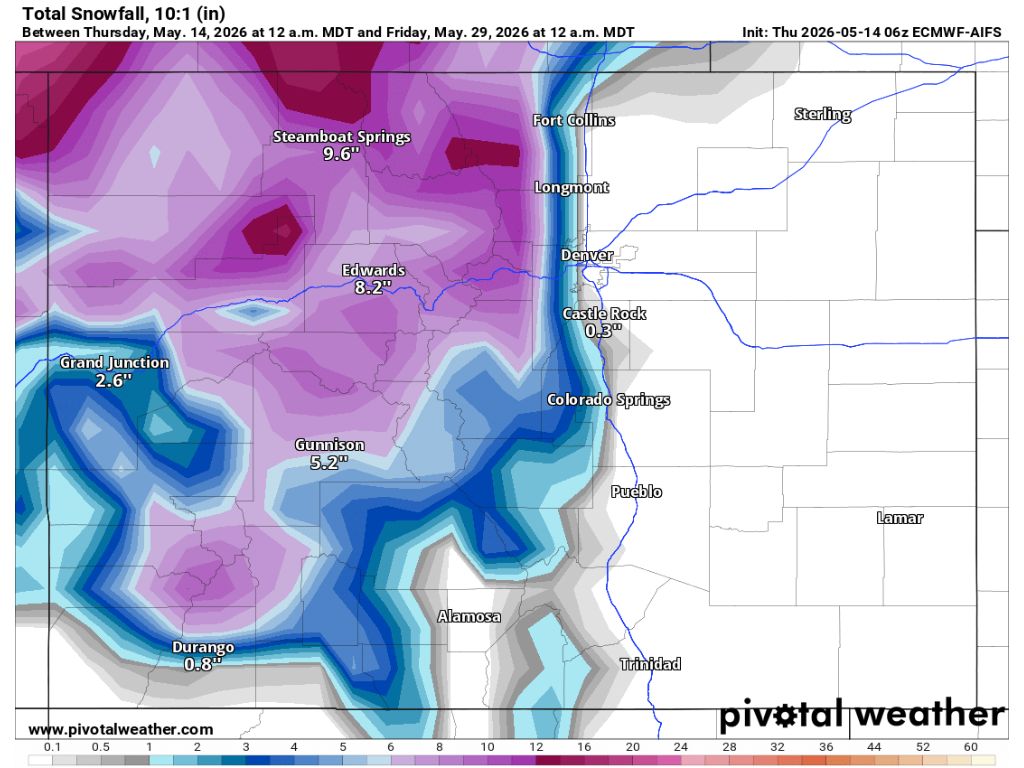
The May snow might not stop there, either. A second round of snow is expected to start hitting the state on May 26, first dropping snow in northwest Colorado and soon expanding to other parts of the Centennial State’s mountainous terrain. This round of snow could bring the total accumulation of both waves combined to up to 16 inches along the state-line by May 29, with a total of about 15 inches in the Flat Tops and about 13 inches in the area of Estes Park. Most other peaks in Colorado would get a total of about five to 10 inches of snow between the two storms, with the I-25 still mostly missed.
The big caveat when it comes to this snow forecast and whether or not it comes to fruition will likely be temperature. Currently, the National Weather Service is calling for the likelihood of warmer-than-normal temperatures in much of Colorado through at least June 5. It looks like some moisture is expected as May continues, but it could end up as rain if high temperatures are present.
As of May 14, statewide snowpack has once again dropped to all-time-low levels at 14 percent of the norm for the date. Snow-water equivalent is at 1.3 inches, which ties the record-low snowpack for the date. In a best case scenario, snowpack is still completely gone in Colorado around the start of June, which is about three weeks ahead of the norm. While additional snowfall over the next couple weeks may be nice, it doesn’t look like these storms are setting up to be significant enough to extend snowpack by much at this time.
It’s also worth noting that drought remains widespread and severe in Colorado, despite the 30-plus inches of snow that landed in some parts of the state in early May.
STAY INFORMED: Get free Colorado news with our daily newsletter (Click here)
Get OutThere
Signup today for free and be the first to get notified on new updates.
PREV
PREVIOUS
Did the big recent snowstorm improve Colorado's drought? New map indicates 'not by much'
The U.S. Drought Monitor has released their first report following a snowstorm that dropped 30-plus inches of snow on some parts of Colorado last week and it indicates all of that moisture didn’t do much to improve Colorado’s drought situation. Looking two weeks back, the entirety of Colorado was experiencing a technical stage of drought […]
New wildfire with multiple start points under investigation in Colorado ski country
At about 10:30 a.m. on May 14, the Eagle County Sheriff’s Office warned the public about a new wildfire that popped up with multiple starts in the area of Squaw Creek Road and Highway 6, both of which were closed due to the blaze. Per the latest U.S. Drought Monitor report, the entirety of Eagle […]