


At least 100 structures damaged in Colorado as fires pass combined 100,000 acres
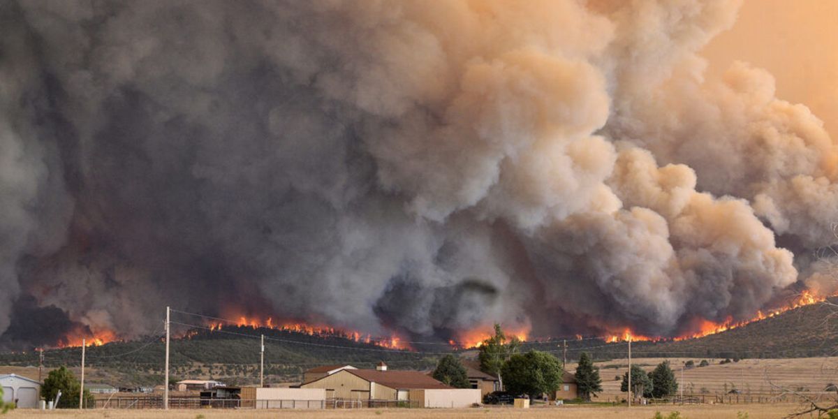
The nine wildfires burning around Colorado have passed 100,000 acres in size, as of Wednesday morning, and while some containment has been gained on some of the blazes, numerous evacuations and pre-evacuation notices remain active around the state.
Here’s a look at what’s on fire around the Centennial State:
Note from the author: Wildfire news can change fast and acreage can sometimes vary by source. This collection of information is based on what seems to be the most accurate at time of reporting considering the many sources that exist, including official pages dedicated to publishing fire updates, as well as applications like Watch Duty. Find additional information about each fire and sources that seem to provide the most up-to-date details linked below.
1. Snyder Fire (which merged with Jones Fire and overtook Knowles and Gore fires
Location: West of Fruita
Size: 30,215 acres
Containment: 10 percent
Update: Per a July 1 update, containment has been gained on the southwest edge of the fire. Growth has been near the Knowles Canyon Trailhead, though heavy smoke from fires farther west have ‘shaded out’ the Snyder Fire, which can help to diminish fire intensity by cooling temperatures and lessening wind gusts. While critical fire weather is expected to continue through the end of the week, lower wind speeds are expected over the next few days.
Find more information here.
2. Gold Mountain Fire
Location: North of Ouray
Size: 14,960 acres acres
Containment: 0 percent
Update: Extreme fire conditions yesterday pushed growth east across the Cow Creek drainage with a significant run taking place up Stealey Mountain toward Owl Creek Pass. Those recreating and dispersed camping in the Silverjack and West Fork areas of the Cimarron drainage were evacuated. Structure and high value protection remain top priorities.
Find more information here.
3. Ferris Fire (which merged with Doe Canyon and Far Draw fires)
Location: Roughly 30 miles northwest of Dolores
Size: 23,287 acres
Containment: 0 percent
Update: Not much new information related to this fire has been released as of 9 a.m. on July 1. That said, yesterday was said to have brought good progress in the fight against this blaze. Fireline work has been productive, though the fire has pushed deeper into Doe Canyon.
Find more information here.
4. Willow Fire
Location: West of Leadville, near Turquoise Lake
Size: Approximately 2,011 acres
Containment: 0 percent
Update: Minor growth continues with evacuations still in place around Turquoise Lake. Pre-evacuations are impacting around 400 homes in the area. The public has been asked to avoid the area around Mount Massive and Hagerman Pass.
Find more information here.
5. Aspen Acres Fire
Location: Southeast Custer County
Size: 28,314 acres
Containment: 0 percent
Update: This blaze continues to prove problematic and while there hasn’t been much of a change in acreage since numbers were published on Tuesday afternoon, that number is expected to increase due to unexpected fire growth on the northwest side of the blaze that occurred on Tuesday evening. Per reporting from The Denver Gazette, officials have said that at least 100 structures have been damaged by the blaze, including the Horseshoe Lodge and Retreat Center in Beulah. That said, the full extent of damages has not been addressed as property owners are still being contacted. Additionally, a CDOT bridge thought to be around 100 years old burned and collapsed in a crucial area near the Aspen Acres campground. At last report, a temporary bridge was set to be installed by Tuesday night.
The situation related to this fire is rapidly changing, with both the Custer County Sheriff’s Office and Pueblo County Sheriff’s Office posting regular updates related to mandatory evacuations.
Find more information here.
6. Red Rocks Fire
Location: North of Clifton, near Debeque
Size: 311 acres
Containment: 95 percent
Update: The fight against this fire has gone well, with containment increasing to 95 percent from 80 percent over the last 24 hours.
Find more information here.
7. 11 Fire
Location: Fremont County, northwest of Cañon City
Size: 107 acres
Containment: 30 percent
Update: There was slight growth of the 11 Fire based on information published to Watch Duty. Containment increased, as well.
Find more information here.
8. McCloud Fire
Location: Dolores County
Size: 113 acres
Containment: 0 percent
Update: No update at this time.
Find more information here.
9. Big Sheep Fire
Location: Huerfano County, west of Big Sheep Mountain
Size: 1,100 acres
Containment: 50 percent
Update: No evacuations at this time, but pre-evacuations are still active. At last report, some local residences still had no power. Containment has increased in recent hours.
Find more information here.
STAY INFORMED: Get free Colorado news with our daily newsletter (Click here)
Get OutThere
Signup today for free and be the first to get notified on new updates.
