


South Chamberlain looks back at Strawberry Fields, forward to bigger plans

Along the new, mile-plus stretch of the Chamberlain Trail, nearby chimes of the Will Rogers Shrine rang to the tune of “Tomorrow.” For the fiercest opponents of Colorado Springs’ land swap with The Broadmoor, the sun may never come out over the issue of Strawberry Fields. But the city has tried to reconcile with this trail.
Funded by The Broadmoor and built by trusted hands at Singletrack Trails, the South Chamberlain trailhead and a 20-vehicle parking lot opened in late May. With a ribbon cutting, the city announced a return to Strawberry Fields. That’s not exactly the case, though, as the path contours a hillside above that meadow, an upper bypass.

Rock faces along the forested section of South Chamberlian Trail. Photo Credit: Seth Boster, The Gazette

Rock faces along the forested section of South Chamberlian Trail. Photo Credit: Seth Boster, The Gazette
Still, people should be pleased by the views and long-term vision for Chamberlain. This represents a step toward an envisioned 26-mile trail system that would cover the foothills between Blodgett Peak and Cheyenne Mountain.
Outdoor enthusiasts continue to gather in the Springs, “and the more opportunities we can provide them, the better,” said David Deitemeyer, senior landscape architect with city parks.
The opportunities are seen in the map posted at South Chamberlain’s parking lot. Facing the trailhead, go right, crossing the street to a split; rather than continue straight, catch the trail bending uphill to the left.
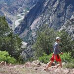
The craggy faces of North Cheyenne Cañon greet you over Strawberry Fields. While openness defines the first half of the trail, the rest of the trip is through a thick forest. Stay straight until you come to a steep washout; see the clear path continuing flat to the right.
The trail switchbacks higher to glimpses of downtown, the plains and Garden of the Gods. It ends unceremoniously at a spot along Old Stage Road. In the future, the idea is to continue the trail system nearby with easements from landowners including the Cheyenne Mountain Zoo, Deitemeyer said.
Trip log: 2.8 miles (out and back), 1,094 feet total elevation gain, 6,802 feet max
Difficulty: Easy-moderate
Getting there: Directly across from the Starsmore Discovery Center, turn onto Evans Road, then right onto Mesa Avenue. The parking lot will be to your right.
FYI: Multi-use, nonmotorized trail. Dogs on leash.
Get OutThere
Signup today for free and be the first to get notified on new updates.
PREV
PREVIOUS
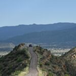
Royal Gorge trails the latest in Cañon City’s outdoor recreation revolution
Facebook Twitter WhatsApp SMS Email Print Copy article link Save Facebook Twitter WhatsApp SMS Email Print Copy article link Save CAÑON CITY • A father and son step off the trail, and Ashlee Sack approaches. “Do you guys have a trail guide?” she asks for Fremont Adventure Recreation, the nonprofit that created the booklet and […]
Dinosaur discovery on Skyline Drive in Cañon City excavated 20 years ago still popular
Facebook Twitter WhatsApp SMS Email Print Copy article link Save Facebook Twitter WhatsApp SMS Email Print Copy article link Save CAÑON CITY • As if the tip-top view from scenic Skyline Drive isn’t awesome enough, another attraction on the narrow, no guardrail-road also sticks out. After entering through a 1932 stone archway off U.S. 50, […]