


Latest snow storm for Colorado stalls, 6-12″ still forecast into next week

The following 7- to 9-day period could deliver more snow daily up to Thanksgiving Day
The constantly evolving weekend forecast for Colorado’s ski areas and resorts has changed, again, but remains promising as moderate amounts of snow will more than likely fall from between Friday to Sunday.
Next week’s forecast offers up more snow for all ski areas ending the very dry first half of November. Eldora and Vail start turning chairlifts this weekend to start their winters respectively.
Possible continued storminess heading into Thanksgiving week should boost other resorts with much needed snow ahead of their opening dates during turkey day and beyond too.
Recap:
Monday and Tuesday in Colorado’s high country saw warm temperatures and dry conditions, again.
The high temperature recorded at Copper Mountain’s mid-mountain station was 48 degrees on Monday and was 48 degrees on Tuesday. At Aspen Mountain’s mid-mountain station, the high temperature on Monday was 42 degrees and was 43 degrees on Tuesday.
Forecast:
From Wednesday to Friday forecasted continued warm (highs in the upper 40s/low 50s) and dry conditions, again, will persist during the day with cold nights (temps below freezing) across all three mountain zones.
Sometime between Friday night and Sunday morning, snow is forecast to return to the state.
The ECMWF model forecasts snow entering northwestern Colorado late Friday night/early Saturday morning, but only for a quick shot for the Park and Medicine Bow ranges. Then the larger scale snow event is inbound Sunday morning from the southwest.
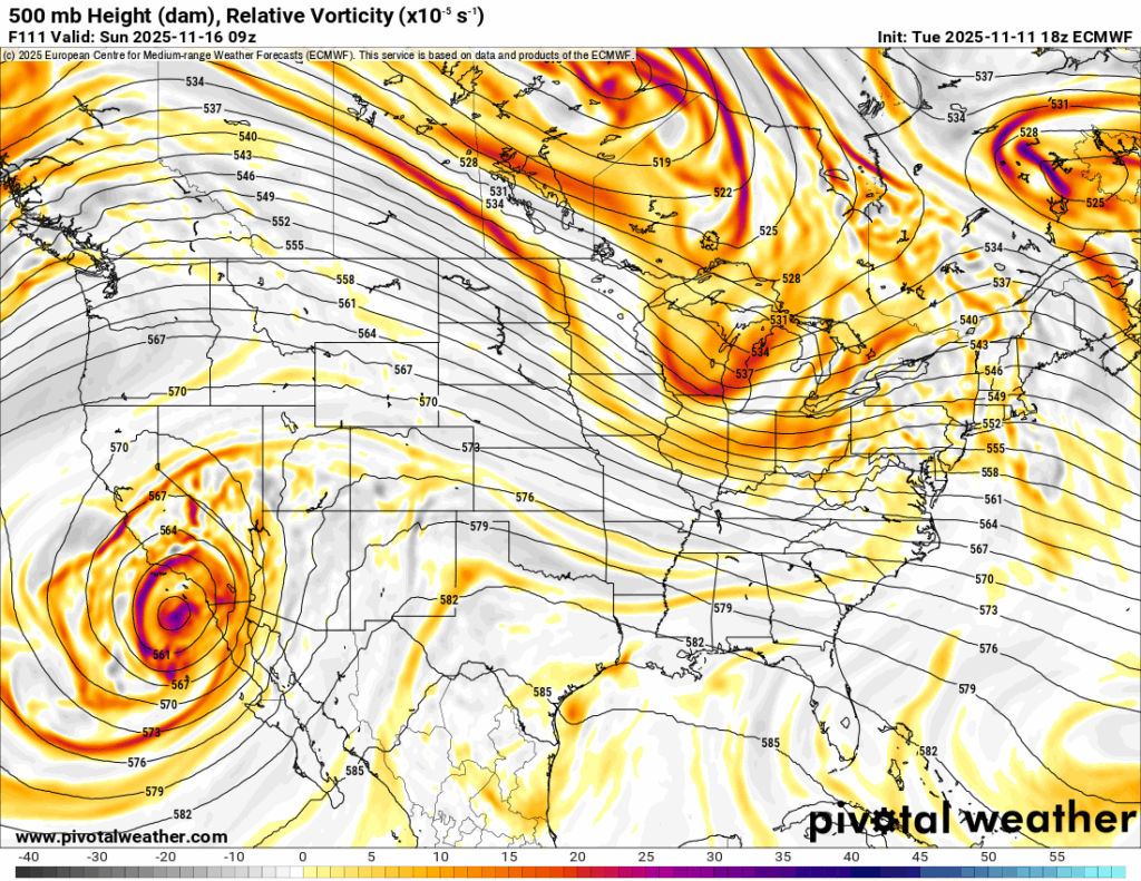
The GFS model forecasts no snow for the northern mountains on Saturday, but the larger scale snow event enters southwestern Colorado on Sunday similarly to the Euro model’s forecast.

If snow falls on Friday night into Saturday, snowfall totals in the northern mountains by end of day Saturday will be between 1-2 inches, mostly around Steamboat, and a trace-1 inch along the Continental Divide between Grand and Boulder counties.
Snow will ramp up Sunday morning from the southwest as both models forecast this event will probably happen now. Snow showers should last through Monday afternoon.
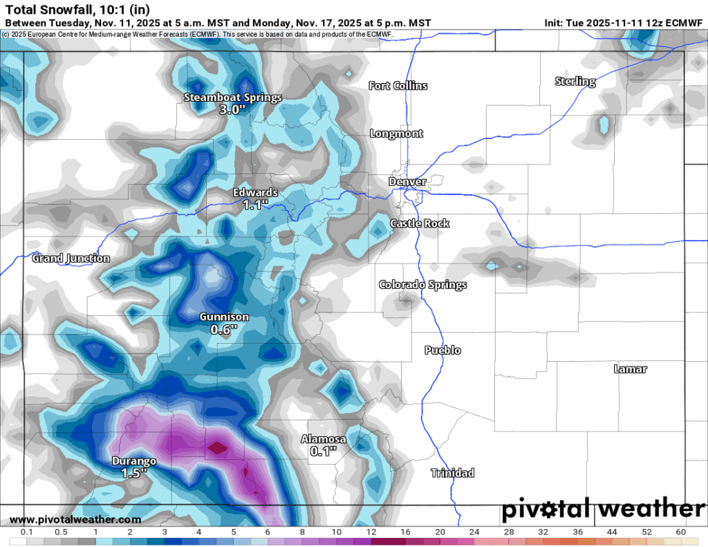
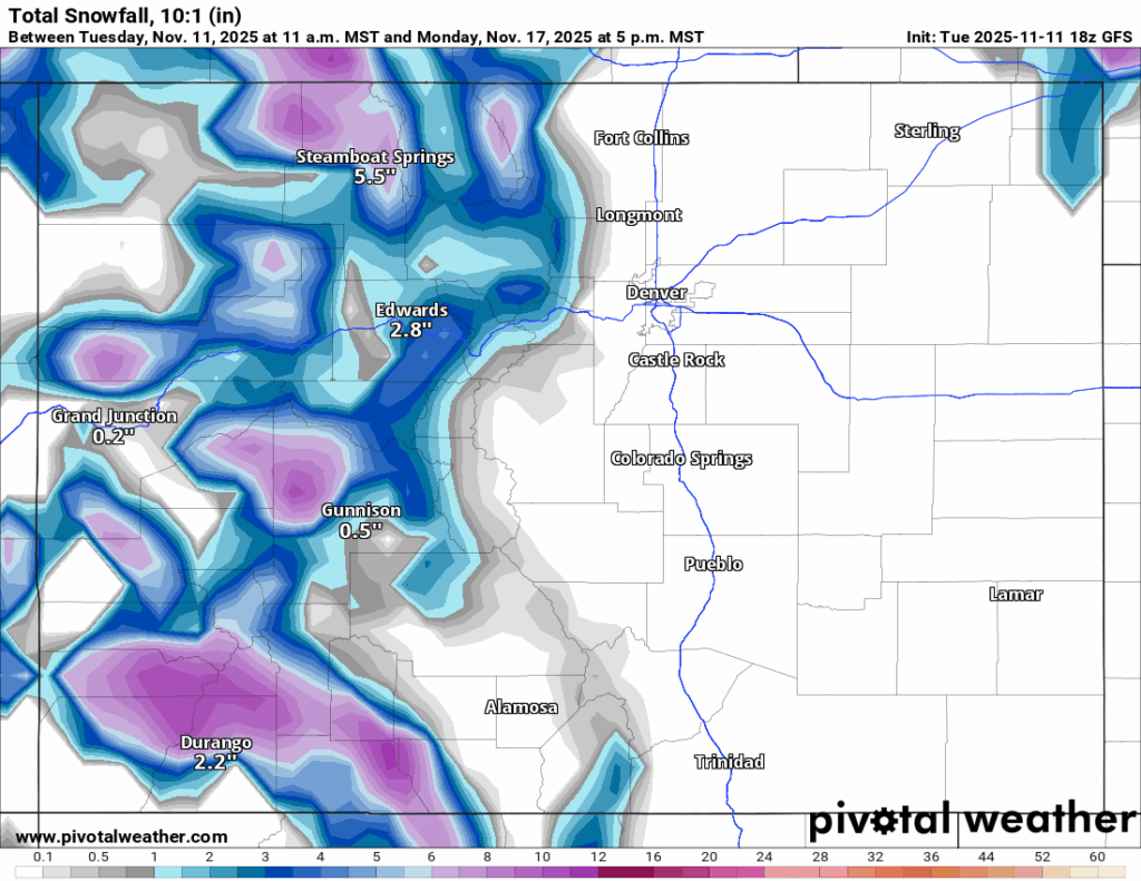
Potential snowfall totals in the northern mountains by Monday afternoon for the northern mountains are between 3-10 inches with the highest amounts in the Park Range, in the central mountains between 5-11 inches and in the southern mountains between 6-12 inches.
ECMWF:
GFS:
Long-term forecast:
Snow is forecast to continue Tuesday through early Wednesday, then again from Thursday, Nov. 20 afternoon to Friday, Nov. 21 evening.
Possible on-and-off storminess is forecast from Saturday, Nov. 22 through Wednesday, Nov. 26 (Thanksgiving Eve).
More details regarding storms past seven days out will need more model renderings to hone in better snowfall totals, timing of storm(s) and duration, however, it is possible based on current models, the state’s high country could receive between 10-20 inches by Thanksgiving Day.
Colorado ski resorts’ planned opening dates and 24-hour totals:
Arapahoe Basin – 0″
Aspen Highlands – Dec. 13
Aspen Mountain – Nov. 27
Beaver Creek – Nov. 26
Breckenridge – 0″
Buttermilk – Dec. 13
Cooper – Dec. 10
Copper Mountain – 0″
Crested Butte – Nov. 26
Echo Mountain – TBD
Eldora Mountain – Nov. 14
Granby Ranch – Nov. 26
Hesperus – Closed for the season
Howelsen Hill – Nov. 29
Kendall Mountain – December
Keystone – 0″
Loveland – 0″
Monarch – Nov. 21
Powderhorn – Nov. 22
Purgatory – Nov. 22
Silverton – Private mountain after Dec. 1, Guided and Heli season Dec. 27
Snowmass – Nov. 27
Steamboat – Nov. 22
Sunlight – Dec. 12
Telluride – Nov. 27
Vail – Nov. 14
Winter Park – 0″
Wolf Creek – Open as soon as conditions allow