


Denver weather: Cold front Friday night forecast to end city’s snowless streak at 224 days
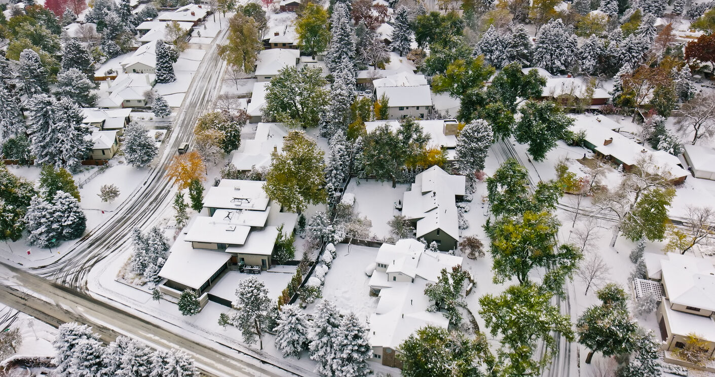
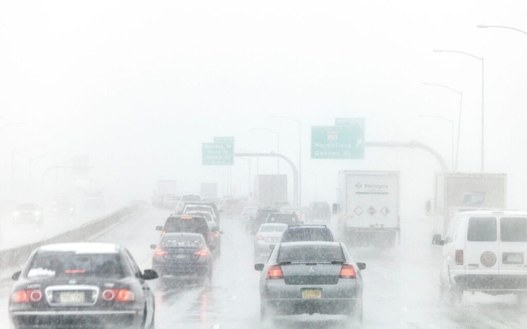
It is probable Denver sees its first snowfall on Saturday as a cold front dips southeastward across Colorado Friday afternoon and evening, potentially ending the snowless streak at 224 days (fourth longest in recorded city-weather history).
But for today, Denver residents can expect mostly cloudy skies, with a high near 62, according to the National Weather Service in Boulder. South winds between 5 to 8 mph become northwest in the afternoon.
Tonight expect a chance of rain showers before 11 p.m., then a slight chance of rain and snow showers between 11 p.m. and 2 a.m., then snow likely after 2 a.m.
It’ll also be mostly cloudy, with a low around 20 and blustery, with a light west northwest wind becoming north between 16 to 21 mph after midnight. Winds could gust as high as 33 mph. Chance of precipitation is 60%. New snow accumulation of less than a half inch possible.
Denver International Airport’s recording station still needs to record 0.1 inches or more of snow in order to solidify an actual date of the latest first snow. That date will be the sole owner of second place. Nov. 21 is the third place spot.
After a cool weekend with potentially more snow Sunday, metro Denver’s weather, as December starts on Monday, rebounds back to dry but cooler than average conditions as high temperatures stay in the 40s for the first half of the week.
Here’s the 4-day forecast from the National Weather Service.
Saturday: Snow likely, mainly before 8 a.m. Mostly sunny, with a high near 32. North northeast wind 7 to 11 mph, with gusts as high as 18 mph. Chance of precipitation is 60%. New snow accumulation of less than a half inch possible.
Sunday: A 20 percent chance of snow after 11 a.m. Mostly cloudy, with a high near 30. North northeast wind 3 to 6 mph.
Monday: Sunny, with a high near 40.
Tuesday: Mostly sunny, with a high near 48.

Weekend things to do around Denver and Beyond: Parade of Lights downtown and more
Linda Navarro
linda-navarro@denvergazette.com
Updated 9 hours ago
Each Thursday, explore Denver’s essential weekend events curated by The Denver Gazette. Dive into cultural experiences and entertainment delights across the city. Whether you enjoy art galleries, pottery, or outdoor sports, there’s something for everyone in Denver’s vibrant cultural scene....
Linda Navarro
Reporter

The next Nickelson? Your new white knight just might be a Black Cowboy
John Moore
john.moore@denvergazette.com
Updated 3 hours ago
2025 DENVER GAZETTE TRUE WEST AWARDS: DAY 4 The founder of Emancipation Theatre ‘is a prophet,’ says Denver blues legend Erica Brown’ I asked “the” Erica Brown how she would introduce formidable independent Denver theater practitioner Jeff Campbell to a...
John Moore
Reporter
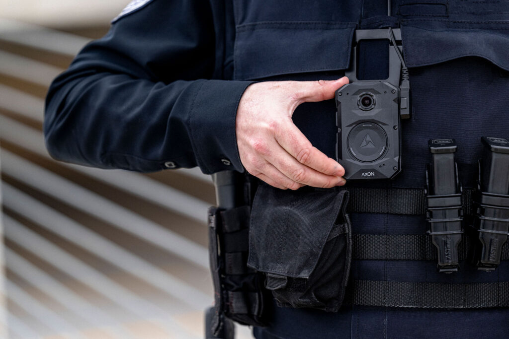
Council will consider $27M contract for Denver police body cameras, tasers
Deborah Grigsby
deborah.smith@denvergazette.com
Updated 4 hours ago
It’s been close to 10 years since the Denver Police Department first donned body-worn cameras in January 2016, and technology has advanced since then. The Department of Public Safety is asking the City Council to approve a new five-year, $27...
Deborah Grigsby
Reporter

Benjamin Moore loft recalls exciting days in Denver’s ballpark neighborhood
Mark Samuelson
mark-samuelson@denvergazette.com
Updated 4 hours ago
Coming into a new year when Denver’s downtown reads like a good-news, bad-news story, homebuyers can tour a 3-bedroom loft this Sunday that’s in an iconic building, in a place that was all the rage during a decade when the...
Mark Samuelson
Reporter
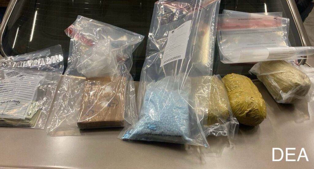
DEA announces seizure of over a million fentanyl pills in Rocky Mountain region
Michael Braithwaite
michael.braithwaite@gazette.com
Updated 4 hours ago
Federal authorities announced Wednesday the seizure of more than one million fentanyl pills during a four-state operation in October. Between Colorado, Utah, Montana and Wyoming, officials seized over 1.05 million individual pills, over 3.5 kilograms of fentanyl powder — enough...
Michael Braithwaite
Reporter
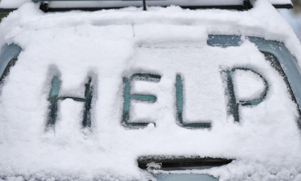
Looking to survive winter driving in Colorado? Pack these 27 items in your trunk
Spencer McKee
spencer@outtherecolorado.com
Updated 7 hours ago
Winter driving in Colorado can come with a bit of risk, as slick and snowy roads might mean getting stuck in traffic for hours at a time or even getting stranded. One piece of travel preparation that can ultimately be...
Spencer McKee
Reporter

Man convicted of first-degree murder in Federal Heights death
Kyla Pearce
kyla-pearce@denvergazette.com
Updated 6 hours ago
An Adams County man was convicted of first-degree murder last week in the fatal stabbing of a 20-year-old woman in Federal Heights in December 2023. 17th Judicial District Attorney Brian Mason announced the conviction of 37-year-old Adrian Carracedo-Vega following a...
Kyla Pearce
Reporter
How to drive in snow and ice in Colorado
Daniel Boniface
dan.boniface@denvergazette.com
Updated 7 hours ago
Buckle up. The winter driving season is upon us. So, if you’re new to Colorado or it’s just been a while since you’ve driven in winter conditions, it’s always a good idea get a quick refresher on how to drive...
Daniel Boniface
Reporter
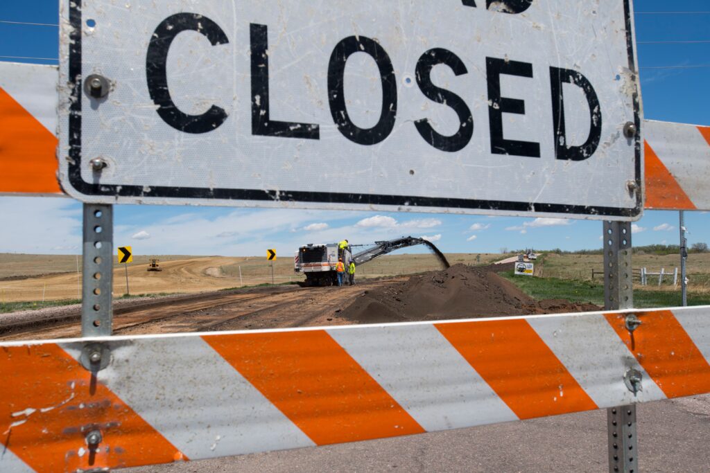
Drivers to encounter I-25 closures at Highway 7
Kyla Pearce
kyla-pearce@denvergazette.com
Updated 6 hours ago
Drivers on I-25 will encounter closures next week at Highway 7 for maintenance, and detours will be in place on Monday and Tuesday nights. The maintenance — putting a concrete girder in place for a new pedestrian bridge — is...
Kyla Pearce
Reporter

One dead, one hospitalized after self-defense shooting in Greeley
Michael Braithwaite
michael.braithwaite@gazette.com
Updated 6 hours ago
One person was shot dead and the shooter, his neighbor, was hospitalized after a Greeley home break in overnight Tuesday. Officials first responded to a residence in the 4200 block of Grand Teton Road just before 1:30 a.m. Wednesday, according...
Michael Braithwaite
Reporter
PREV
PREVIOUS

Colorado Supreme Court to examine whether corporations can be liable for 'felonious killing'
The Colorado Supreme Court recently announced that it will determine whether corporations can be liable for a “felonious killing,” meaning there is no limit to the damages they might pay for pain and suffering after causing a wrongful death. At least three of the court’s seven members must agree to take a case on appeal. […]
With 6-12" of snow possible, November ends snowy in Colorado, carries storminess into December
After a rather dry November in Colorado’s high country, Loveland Ski Area recorded 25″ of snow for the month currently, December’s forecast looks more promising as more storms line up over the next week. Snow returns Friday to close out the month on a snowy note, with the northern mountains benefiting the most. As December […]