


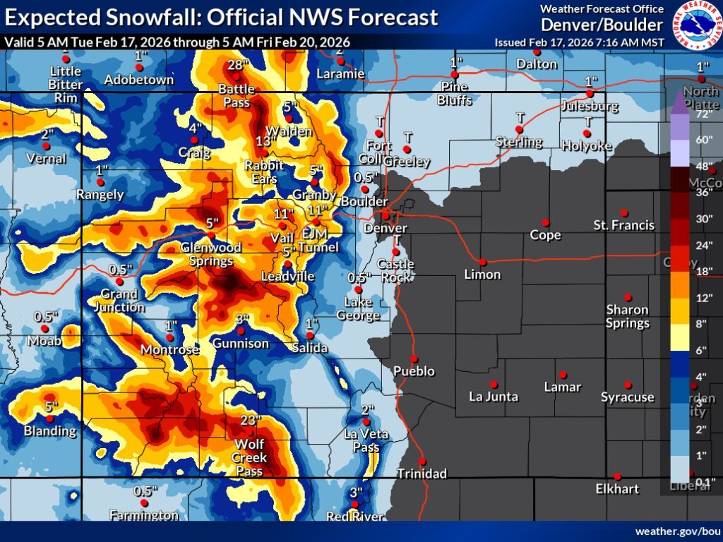
Widespread snow totals of 18-plus inches expected across Colorado’s mountains this week

Winter weather is roaring into Colorado this week, with big snow and a drop in temperature expected.
According to mapping from the National Weather Service, the most likely snowfall scenario will mean at least 8 inches of snow across the state’s mountainous terrain through Friday morning.
Many of Colorado’s mountains should see much more than that, though, with widespread totals between 18 inches and 36 inches expected. Favored areas will include Aspen, Steamboat Springs, and much of the San Juans, with most of the snow falling between Tuesday and Wednesday.
It’s also worth noting that the agency’s “high-end” snowfall forecast (10% chance) depicts what would be a much more impactful winter storm situation. If this scenario unfolds, peaks in the Aspen area could get more than 48 inches of snow, with Wolf Creek Pass looking at about 42 inches. Accumulation totals above 18 inches would be widespread across Colorado’s west.
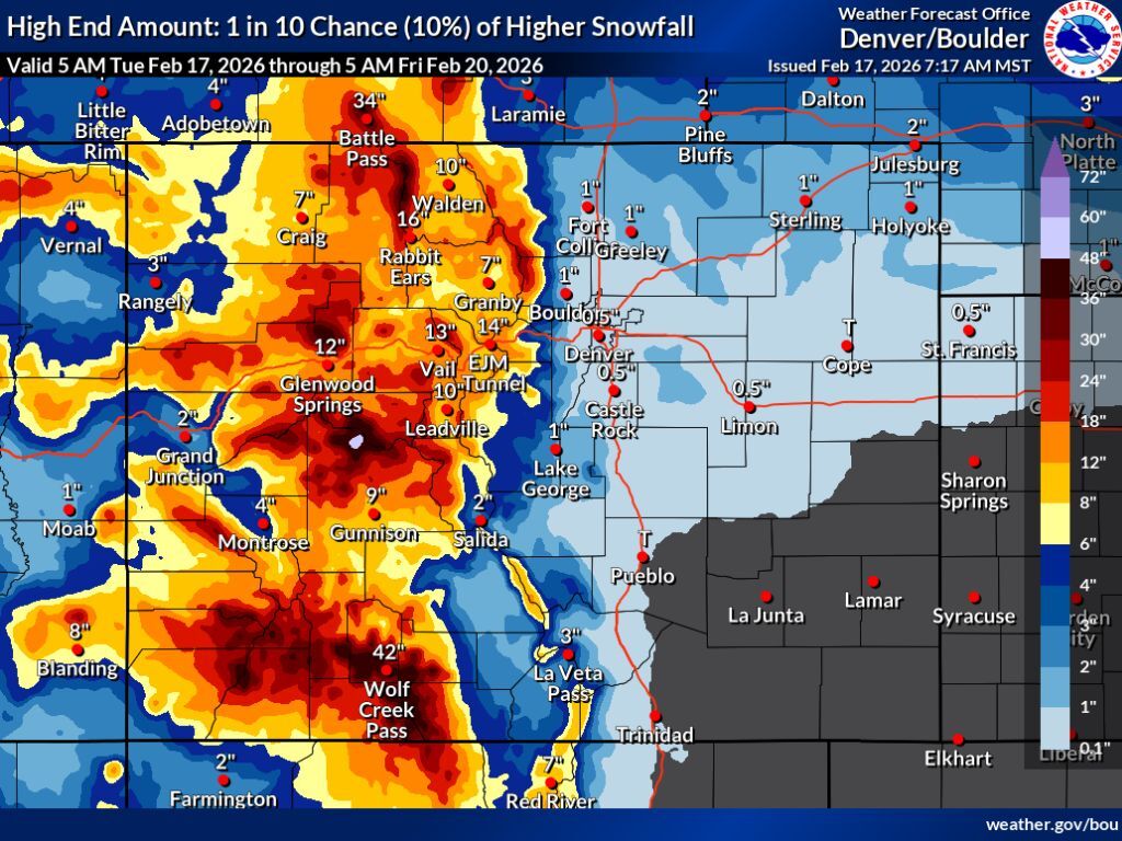
In both the “expected” and “high-end” snowfall scenarios, the National Weather Service calls for little-to-no snow along the I-25 corridor. Impacts related to this round of wintery weather should be mostly limited to those traveling in Colorado’s mountainous terrain.
Various winter storm warnings and winter weather advisory alerts have been activated in western Colorado, with officials warning that travel this week could be difficult to impossible.
According to the OpenSnow report, Wolf Creek ski area should get the most snow between Tuesday and Saturday – about 45 inches. Meanwhile, Purgatory should get about 31 inches and Crested Butte could get 28 (find a full resort-by-resort breakdown here).
As of the morning of Feb. 17, Colorado’s statewide snowpack was at 55 percent of the norm – a record low for the date with a snow-water equivalent of 6.2 inches.
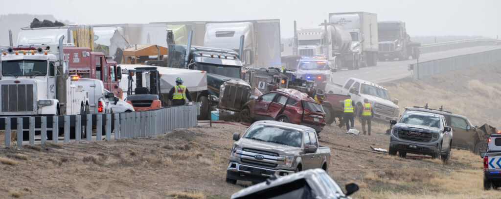
4 dead, 29 injured in I-25 crash involving 36 vehicles near Pueblo
Alexander Edwards
alexander-edwards@denvergazette.com
Updated 5 hours ago
Northbound Interstate 25 remained closed south of Pueblo late Tuesday night following a 36-vehicle crash that killed four people and injured 29 others, according to Colorado State Patrol. The closure extends from Exit 91 to Exit 94. There is a...
Alexander Edwards
Reporter

Colorado Senate presses transportation director to increase funding for Morgan County roads
Marissa Ventrelli
marissa-ventrelli@denvergazette.com
Updated 8 hours ago
A coalition of state Senators approved a resolution drafted by the Morgan County Board of Commissioners urging the Colorado Department of Transportation to invest more money into fixing roads. Some 70% of Morgan County’s roads have been labeled by the...
Marissa Ventrelli
Reporter

Metro Moves: Ikea will open store in Fort Collins
Bernadette Berdychowski
bernadette.berdychowski@denvergazette.com
Updated 10 hours ago
Welcome to the Denver Gazette’s Metro Moves. You’ll get the latest metro Denver openings, closings, hiring and promotion news here. To submit your company’s news, drop an email to bernadette.berdychowski@denvergazette.com. Ikea, the Swedish furniture store, is opening a new location in...
Bernadette Berdychowski
Reporter

Denver school board to consider property swap
Nicole C. Brambila nico.brambila@denvergazette.com
nico.brambila@denvergazette.com
Updated 7 hours ago
The Denver Public Schools board will consider replacing an administrative building with Pascual LeDoux Academy in the district’s 2020 lease-purchase structure, a financing arrangement tied to the sale and leaseback of several school buildings now under legal challenge. The deed...

Democrats want to decouple Colorado from federal tax breaks
Marissa Ventrelli
marissa-ventrelli@denvergazette.com
Updated 7 hours ago
Democratic members of Colorado’s House and Senate on Tuesday announced the introduction of a slew of bills that would reduce corporate tax deductions and sever Colorado’s tax regime from recent federal changes to the tax code. The federal tax changes...
Marissa Ventrelli
Reporter

Greeley police chief hit bicyclist in crash, police say
Sage Kelley
sage.kelley@denvergazette.com
Updated 7 hours ago
The chief of the Greeley Police Department allegedly struck a teen bicyclist while driving an off-duty car. Adam Turk struck a 15-year-old boy with an unmarked Chevrolet Tahoe on West 26th Street and 53rd Avenue in Greeley around 2:30 p.m....
Sage Kelley
Reporter

Ballot measure seeks to enshrine ‘right to know’ government affairs in Colorado Constitution
Marianne Goodland
marianne-goodland@denvergazette.com
Updated 4 hours ago
A ballot measure filed Friday would enshrine people’s “fundamental right to know” the affairs of governments, thereby overturning a 2024 law that allowed lawmakers to shield their activities from the public. Supported by by groups that aren’t always on the...
Marianne Goodland
Reporter

Palantir moves HQ from Denver to Miami
Bernadette Berdychowski
bernadette.berdychowski@denvergazette.com
Updated 7 hours ago
Palantir Technologies Inc., a large artificial intelligence and software company with many government contracts, including federal immigration forces and the U.S. military, is moving its headquarters out of Denver. “We have moved our headquarters to Miami, Florida,” the company posted...
Bernadette Berdychowski
Reporter
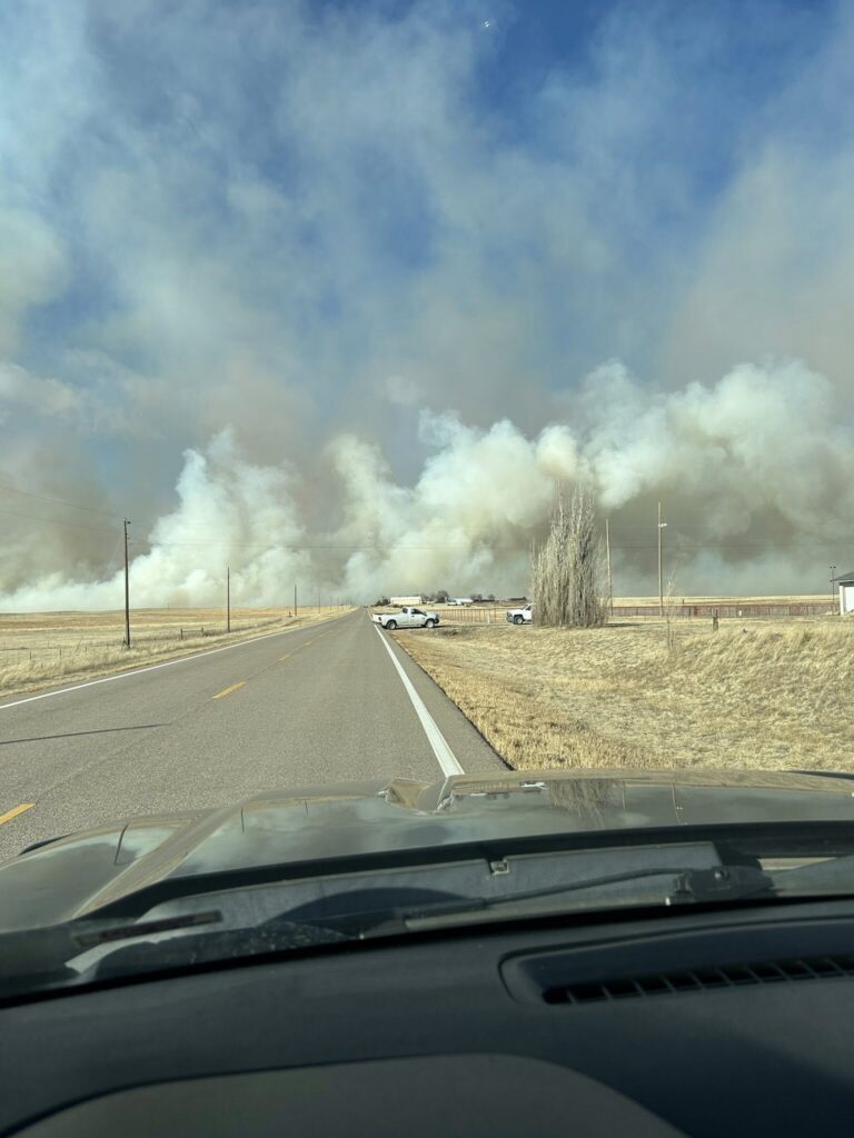
Fire near Limon forced evacuations, but under control
Kyla Pearce
kyla-pearce@denvergazette.com
Updated 7 hours ago
A vegetation fire just southwest of Limon broke out Tuesday afternoon, reaching several miles in length and jumping Highway 181, according to fire tracking site WatchDuty. An evacuation order was issued for the area from County Road 2T to County...
Kyla Pearce
Reporter
Denver considers AI-powered permitting contract
Deborah Grigsby
deborah.smith@denvergazette.com
Updated 7 hours ago
Submitting an application with Denver’s Permitting Office may soon be faster and less frustrating if a contract for a new AI-driven platform passes muster with the full City Council. Members of the city’s Governance and Intergovernmental Relations Committee on Tuesday...
Deborah Grigsby
Reporter
PREV
PREVIOUS

Metro Moves: Ikea will open store in Fort Collins
Welcome to the Denver Gazette’s Metro Moves. You’ll get the latest metro Denver openings, closings, hiring and promotion news here. To submit your company’s news, drop an email to bernadette.berdychowski@denvergazette.com. Ikea, the Swedish furniture store, is opening a new location in North Colorado. The company announced it will open in Fort Collins this year, its third […]

Colorado Senate presses transportation director to increase funding for Morgan County roads
A coalition of state Senators approved a resolution drafted by the Morgan County Board of Commissioners urging the Colorado Department of Transportation to invest more money into fixing roads. Some 70% of Morgan County’s roads have been labeled by the transportation agency as having “low drivability life,” according to the resolution, which was introduced by […]