




Forecaster spent 6 hours ‘pinned to tree’ after getting hit by avalanche in Colorado
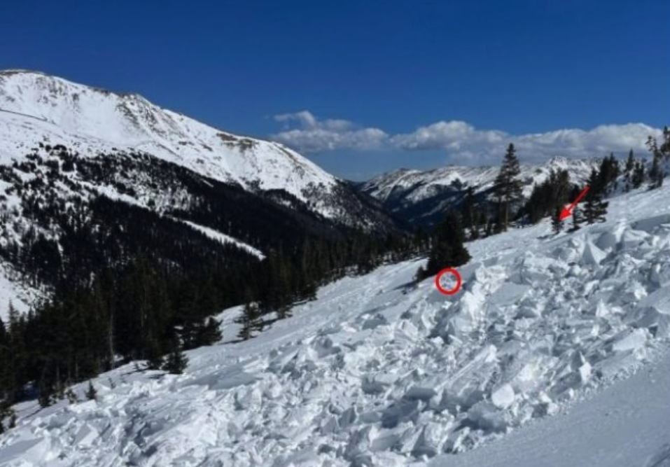
The Colorado Avalanche Information Center has released additional information related to an incident in which one of their forecasters was struck and partially buried by a slide while working in the backcountry on April 8.
On the day of the slide, the avalanche forecaster entered the backcountry near Herman Gulch (north of I-70 and just east of the Eisenhower Tunnel), planning for a day of fieldwork for the Colorado Avalanche Information Center (CAIC) that focused on collecting information related to the development of wind slab avalanche conditions in the area. He also hoped to evaluate the sensitivity of a persistent weak layer in the snowpack, having previously submitted details about his plans that included what route he would follow, when he planned to return, his goals for the day, and what risks he might encounter, along with a risk mitigation strategy. Another forecaster reviewed his safety plan per CAIC policy and he entered the field at about 10:30 a.m., leaving the Mount Herman trailhead behind and heading to the eastern ridge of Mount Bethel on skis.
The first portion of his day went well. He had reached treeline by noon and spent about an hour digging through layers of snow to investigate snowpack conditions. After wrapping up his work, he started what the CAIC called a “slow downward traverse” on a low-angled gully with a slope angle of about 20 to 25 degrees.
At roughly 1:30, he heard a boom from an avalanche that broke about 40 feet above him at an elevation of about 11,840 feet where the slope angle was determined to be 32 degrees. The slide was about 130 feet wide and while he attempted to ski out of the moving debris, large hard snow blocks made it difficult. He ultimately lost a ski, but was able to deploy his avalanche airbag.
After getting knocked off his feet, he was carried about 50 feet by the slide (which would ultimately run about 200 feet downslope), coming to a stop partially buried and pinned against trees in an upright seated position. His legs, lower torso, and left arm were buried under the snow.
He was unable to free himself and after painstakingly accessing his cell phone, he realized it was damaged and not functioning properly. With his backpack pinned against the tree and securely strapped to his body, he struggled to access its contents, including a GPS device.
By about 4:30 p.m., he was finally able to get into the top compartment of his pack and find his emergency satellite communication device. At that point, it was about three hours after the slide had taken place.
The forecaster attempted to send a distress signal, but according to the CAIC, avalanche debris and the tree canopy interfered with the message getting delivered.
Meanwhile, Colorado Avalanche Information Center staff realized that the forecaster did not return as planned by 5:00 p.m. This prompted emergency protocol. After contact with the forecaster failed via phone and radio, their team was able to see that his last satellite transmission was at 1:20 p.m., sent from the bottom of a small avalanche path on the eastern side of Mount Bethel. By 5:04 p.m., a rescue response was initiated.
At 5:11 p.m., CAIC suspicions of a problem were confirmed, when the forecaster was finally able to get his first SOS message out.
At about 6:15 p.m., rescuers left the Herman Gulch trailhead, eventually reaching the forecaster at about 7:23 p.m. – nearly six hours after he was partially buried by the slide.
The team dug the forecaster out of the snow and assessed his injuries, also working to warm him up.
Clear Creek County’s Alpine Rescue Team was also deployed into the field via a Flight for Life helicopter to help transport the forecaster back to the trailhead by ground, with that process starting at about 8:09 p.m. By 10:15 p.m., the forecaster was back at the trailhead and transported to the hospital via ambulance with non-life-threatening injuries.
As is the norm, Colorado Avalanche Information Center provided an after-incident analysis.
CAIC pointed to how this case shows how important a satellite-based communication device can be. Even though the forecaster was unable to send a message out for more than three hours after the slide, CAIC crews were able to see where the coordinates of the last pinpoint sent by the device, allowing them to launch a mission. This incident also goes to show how even in a case of having a GPS-based communication unit, things can still go wrong, as demonstrated by how the device was inaccessible due to the forecaster’s position in the snow and then by how the device was unable to send a message immediately. This provides an example of why it’s so important to communicate a plan with someone not in the backcountry prior to leaving the trailhead, also sticking to that plan as the day goes on. In this case, CAIC knew the forecaster’s plan, which would have helped them launch a mission even if the GPS device pinpoint wasn’t available.
As for the forecaster being in the field alone, this increases risk but this risk is accepted by forecasters in some working scenarios:
“The Center’s approach to risk management for any work project is to maintain a process that allows staff to identify hazards, plan mitigation strategies, and compare the residual risk with the benefit to the program. This process does not preclude traveling alone. Nor does it allow solo travel in every circumstance,” read the report from the Colorado Avalanche Information Center.
This incident also goes to show how dangerous the backcountry can be, even with proper planning. Colorado Avalanche Information Center forecasters take on a lot of risk to help keep the public safe. Those looking to help support their efforts can do so here.
Read the full report about this incident here and remember, always check the risk level on the Colorado Avalanche Information Center website prior to a backcountry adventure – as close as possible to when you leave the trailhead.
Get OutThere
Signup today for free and be the first to get notified on new updates.
PREV
PREVIOUS

Denver neighborhood an 'urban haven,' blending big city amenities with rural comforts
According to a recent report from the publication Easy Coops, Highlands in Denver is Colorado’s “top urban haven.” The researchers ran an online survey of 3,000 adults based on age, gender, and geography, to determine each state’s top urban haven – places “that blend city convenience with rural tranquility.” They used a two-step process to […]

6 safety tips for a water tubing adventure in Colorado
Tubing is a great activity that offers the opportunity to both relax and enjoy the excitement of the river. However, it’s always important to keep safety in mind while on the water. Here are five tips to help keep you safe during tubing season this year, also sure to contribute to a great time on […]