


12-30 inches of snow forecast for Colorado’s mountains from 1, 2 storm punch | Whiteout daily snow report

Southwestern and western portions of Colorado are still in the bullseye for potentially heavy snow accumulations from the first of two snow storms headed for Colorado this upcoming week. Northern areas will get their share from the second storm.
The first storm is forecast to begin Monday night, lasting through Wednesday night, then the second, weaker storm, starts late Thursday night (Halloween), lasting through Saturday morning.
Recap:
Friday and Saturday were very warm across Colorado’s high country. Highs were in the 40s and 50s on Saturday with Copper Mountain recording a high of 49, according to the National Weather Service in Boulder.
Snow making was also limited to non-existent as temperatures and humidity levels were not prime for snow making time. However, that should all change come Monday night.
Forecast:
On Monday afternoon, a southward dipping low pressures system will bring rain and snow into western Colorado, with snow beginning to accumulate in mountainous regions overnight.
The storm track looks to cross through Colorado from southwest to northeast, with upper level wind speeds pushing 100 knots.
Temperatures are forecast to be in the 20s overnight Monday, reach around freezing Tuesday and then plummet into the teens Tuesday night and overnight Wednesday.
Forecast models from the GFS and ECMWF show differing accumulations.
The GFS model forecasts 18-30 inches, whereas the ECMWF predicts 12-18 inches to fall in the San Juan mountains around Telluride, Silverton, Lake City and Wolf Creek Pass.
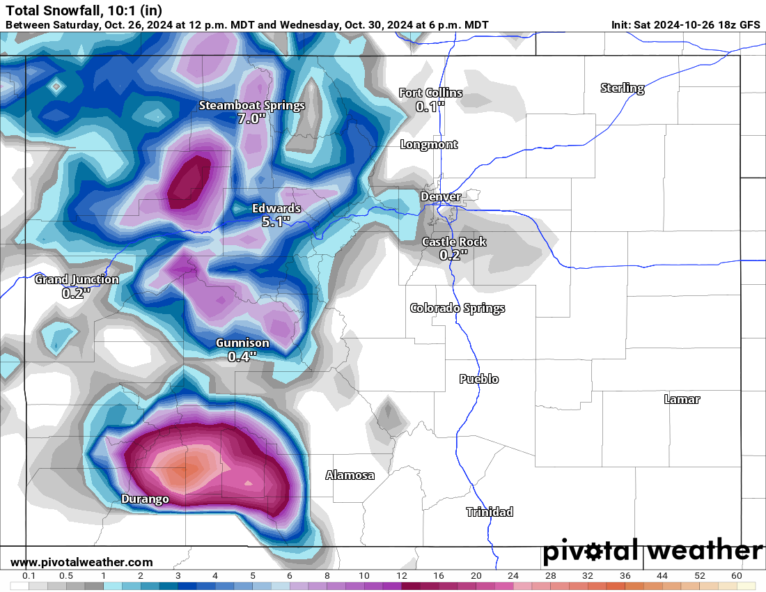

The ECMWF forecast historically has been more accurate with snow accumulation totals, but regardless, ski areas in the southwest are in for another 1-1.5 feet of snow.
The central mountains will also benefit from this first storm.
The West Elk and Elk mountains should see 8-12 inches of snow by Wednesday night. The Flattops could see 8-12 inches, locally up to 16 inches if the storm track stays a bit farther north.
The northern mountains could receive 4-8 inches.
In and around metro Denver, snow accumulations more than likely will be minimal, with slushy and wet snow, but a trace-0.5 inch is possible farther north toward Fort Collins and the Wyoming/Colorado state line.
Long Range:
Some time Saturday, Nov. 2 afternoon, the second storm is forecast to make a push into northwestern Colorado, giving the northern mountains a good shot at snow, with the state receiving snow for about 48 hours.
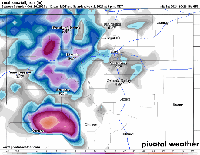
Similar to the first storm, this low pressure system is forecast to push through Colorado a little farther north on a more northwest to southeast flow initially, then shifting to a west southwest to east northeast flow.
The GFS model forecasts additional snow accumulations in the northern mountains between 7-14 inches, 3-6 inches in the central and southern mountains.

Snow is forecast to finally fall in Front Range cities and Interstate 25 corridor from Fort Collins to Trinidad starting Nov. 3. The greater totals are forecast to be south of Interstate 70 in Jefferson and Douglas counties, with potentially between 4-12 inches.
South and east of Pueblo, snow accumulations could be between 4-8 inches as well.
Editor’s note: Wolf Creek Ski Area is the only open ski area in Colorado currently, however, once a few more ski areas and resorts open for the season, the Whiteout ski area conditions map will be updated daily with information about conditions, open trails, and 24-hour snow totals.
Today’s 24 hour snow totals from Colorado resorts:
Arapahoe Basin – Closed for season
Aspen Highlands – Closed for season
Aspen Mountain – Closed for season
Beaver Creek – Closed for season
Breckenridge – Closed for season
Buttermilk – Closed for season
Cooper – Closed for season
Copper Mountain – Closed for season
Crested Butte – Closed for season
Echo Mountain – Closed for season
Eldora Mountain – Closed for season
Granby Ranch – Closed for season
Hesperus – Closed for season
Howelsen Hill – Closed for season
Kendall Mountain – Closed for season
Keystone – Closed for season
Loveland – Closed for season
Monarch – Closed for season
Powderhorn – Closed for season
Purgatory – Closed for season
Silverton – Closed for season
Snowmass – Closed for season
Steamboat – Closed for season
Sunlight – Closed for season
Telluride – Closed for season
Vail – Closed for season
Winter Park – Closed for season
Wolf Creek – 0″